| Central Great Plains
Chapter VIII
Emporia State University Emeritus |
|
| Central Great Plains
Chapter VIII
Emporia State University Emeritus |
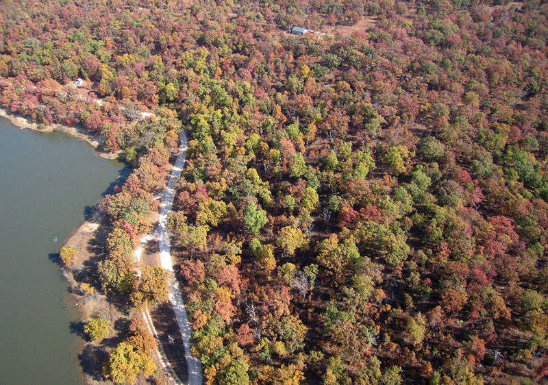
| Woodson County State Fishing Lake and Wildlife Area in the Chautauqua Hills. Note the dense oak forest on the sandstone bluff east of the lake. Autumn foliage is evident in this early November view. Helium-blimp airphoto. |
 Return to beginning.
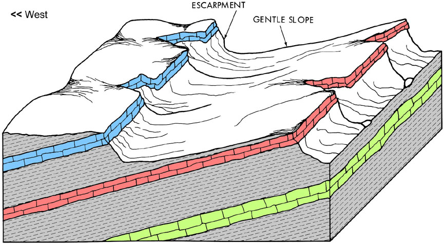 Schematic diagram of cuesta landforms typical in eastern Kansas created by differential erosion of gently dipping limestone and shale layers. The landscape resembles giant stairsteps slightly tilted down toward the west. Adapted from Wilson (1978).
| |
Trending from north-northeast to south-southwest are several narrow escarpments formed on thick, resistant limestone layers. These are present both in the Osage Cuestas and Glacial Hills. Good examples include Hancock Hill at Fort Leavenworth, Mount Oread in Lawrence, Burnett Mound in Topeka, Sugar Mound at Mound City, and Table Mound at Elk City Lake. Along such prominent escarpments, local relief may exceed 300 feet (90 m) and landslips may happen on steep shale slopes below the limestone cap. Between major escarpments, however, cuestas may display quite low relief.

| Butcher Falls, near Sedan in Chautauqua County. A massive layer of Plattsmouth Limestone supports the waterfall. The Plattsmouth Limestone Member is part of the Oread Limestone, which forms a prominent escarpment across eastern Kansas from Leavenworth to Lawrence and southward to Sedan. |

| Superwide-angle autumn overview of mixed land use in the Osage Cuestas near Americus in Lyon County. The region is underlain by shale interbedded with thin limestone layers. Pastures, crop fields, wooded tracts, and small ponds are typical of upland areas. Kite aerial photograph by ESU students. |
The region is underlain by Upper and Middle Pennsylvanian bedrock in which layers are arranged in repeated cycles. These cyclothems of eastern Kansas were made famous by state geologist R.C. Moore, who described and interpreted these strata and their invertebrate fossils in the mid-twentieth century (Moore 1964). The dominant rocks of Pennsylvanian cyclothems are shale, limestone, and sandstone. Distinctive elements include coal beds and black shale. In contrast with Permian cyclothems of the Flint Hills, chert is relatively scarce within the limestone units, red shale is rarely present, and sandstone is common, particularly toward the south. These repeated cycles of deposition represent advances and retreats of shallow seas across the region during the Pennsylvanian, when North America was situated near the Equator in a tropical climatic zone.
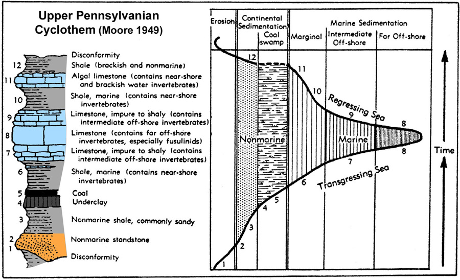 Classic model for an Upper Pennsylvanian cyclothem. Numbers (1-12) indicate stages of marine transgression and regression and the resulting sedimentary deposits. Adapted from Moore (1949); used with permission, Geological Society of America.
| |
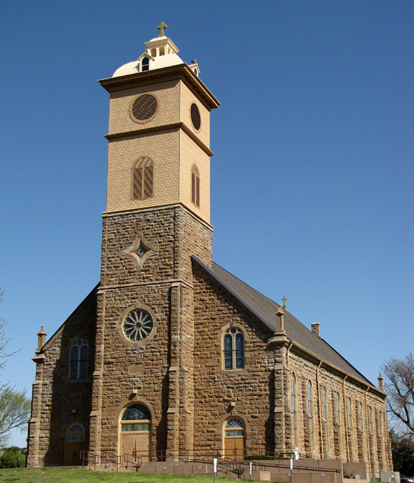
| St. Francis de Hieronymo Catholic Church in the Osage Cuestas of Neosho County. The building was constructed in 1871-1884 of native sandstone, presumably the Bandera Quarry Sandstone Member of the Marmaton Group. Overview (left) and detail of the nave wall (right). Sandstone represents the regressive phase (2) of a cyclothem. Scale pole marked in feet. | 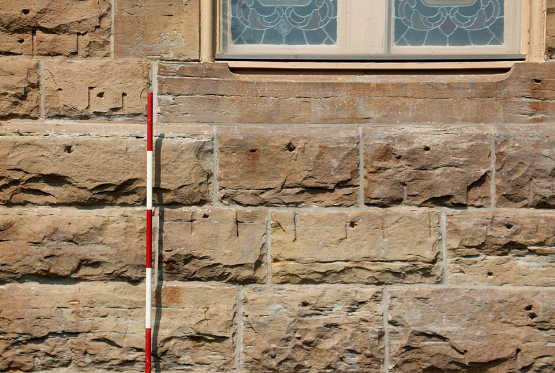
|
Return to beginning.
Early spring view over the broad valley of the Neosho River at St. Paul, Kansas. This vicinity is underlain mainly by easily erodible Holdenville Shale and Nowata Shale of the Marmaton Group. Kite aerial photograph.
| |
As streams cut downward into their modern valleys, they also migrated sideways. Most rivers flow generally from west to east or northwest to southeast, and through time they have shifted systematically southward during valley entrenchment. Thus, terraces and old channel gravels are found mostly along northern sides of valleys. The gravels are composed mainly of chert, derived from the Flint Hills, and are similar to the Leon Gravel (Aber 1992). Most of these gravels also contain exotic quartz and quartzite pebbles derived from the High Plains and Rocky Mountains, which indicates the ancestral rivers had headwaters much farther to the west than do modern streams of the region (Aber 1997).
| Hill-top chert gravel in northwestern Emporia. Typical exposure (left). Gravel rests on weathered bedrock of the Wood Siding Formation. Note iron oxidation (reddish brown) in the gravel and underlying bedrock. Selected exotic pebbles (right). Most are quartzite; pebble at lower left is granite. Taken from Aber (2018). | 
|
This is a good example of inversion of topography, in which what was the lowest feature—gravel deposits in river channels—is now in the highest landscape position—terrace gravel on drainage divides. Assuming a late Pliocene age for the highest chert-gravel terraces gives a vertical incision rate of 1.5 cm/1000 years and a lateral (southward) stream migration rate of >2 m/1000 years (Aber 2019).
Most larger cities are located within river valleys because of the proximity to surface water. However, flooding is a perennial problem owing to infrequent strong storms and high runoff rates from the mostly shaley uplands. Many large reservoirs have been constructed for flood control, recreation, and water supply, and tens of thousands of small ponds have been built throughout the region. In spite of these precautions, flooding remains a danger, as Coffeyville, Iola, and other cities experienced in 2007. In river valleys, alluvial sediment may provide ample high-quality groundwater for domestic, agricultural, and city use. In uplands, however, groundwater is scare, hard, or mineralized with iron and manganese.
Large reservoirs in eastern Kansas suffer from rapid sedimentation that has reduced surface water storage significantly. Of 24 federal reservoirs, nearly half had lost more than 15% of their original storage capacity by 2015 (deNoyelles et al. 2016). Six already had lost more than one-third of their capacity, and Tuttle Creek and Toronto had each exceeded 40% loss. The primary reasons for rapid infilling of these reservoirs are erodible and nutrient-rich soils in the agricultural croplands that make up much of the drainage basins. Dealing with this problem is a long-term challenge for which there are no easy solutions.
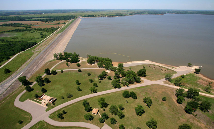
| Major reservoirs dammed on rivers in the Osage Cuestas. Fall River Lake in Greenwood County (left), and Pomona Lake in Osage County (right). Fall River has lost more than one-third of its original storage capactiy, and Pomoma has lost nearly one-quarter of its capacity. Kite and helium-blimp airphotos by ESU students. | 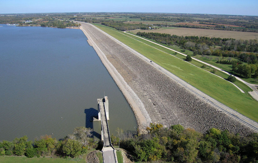
|
| Wind farm | Region | County | Wind speed | Year |
|---|---|---|---|---|
| Central Plains | High Plains | Wichita | 8.5-9.0 m/s | 2009 |
| Cedar Bluff | High Plains | Ness | 9.0-9.5 m/s | 2015 |
| Diamond Vista | Smoky Hills | Marion | 8.5-9.0 m/s | 2018 |
| Reading | Osage Cuestas | Lyon, Osage | 8.0-8.5 m/s | 2020 |
| Ad Astra | Osage Cuestas | Coffey | 8.0-8.5 m/s | 2015 |
| Prairie Queen | Osage Cuestas | Allen | 7.5-8.0 m/s | 2019 |
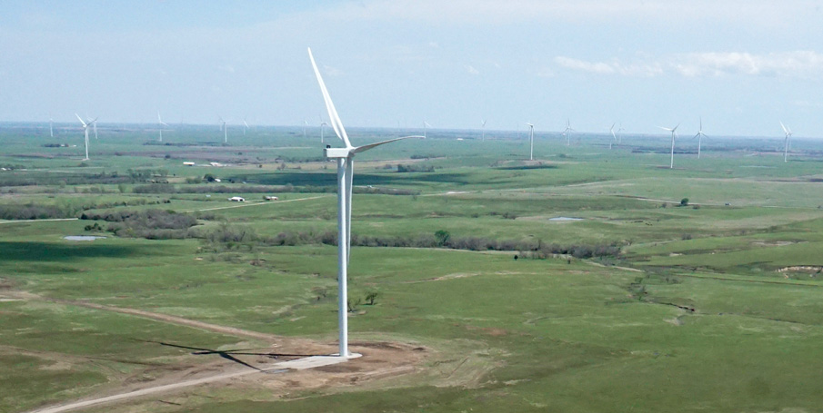
| Newly erected, but not yet operational Siemens Gamesa wind turbines in the Reading wind farm in the spring of 2020. Total height of this turbine is 134 m (440 feet). Located near the Missouri-Arkansas drainage divide in the Osage Cuestas, Lyon County. Kite airphoto. |
Return to beginning.
 Physiographic features of southeastern Kansas showing the "Chautauqua Platform" (gray) and several prominent escarpments in the Osage Cuestas. Cross hatching indicates the Ozark Plateau. Modified from Adams (1897-98).
| |

| Exposure of sandstone in the Douglas Group near Sedan in Chautauqua County. The sandstone channel is about 8 feet thick at its center and thins to 3-4 feet thick to the left and right. Scale pole marked in feet. |
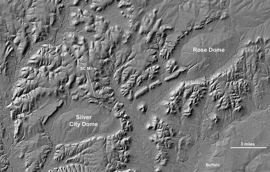 Silver City and Rose domes, near Buffalo in southeastern Kansas. Location of the Silver City (SC) mine is indicated. Shaded-relief digital elevation model based on high-resolution lidar data. Adapted from an image prepared by A. Peterson; used with permission.
| |
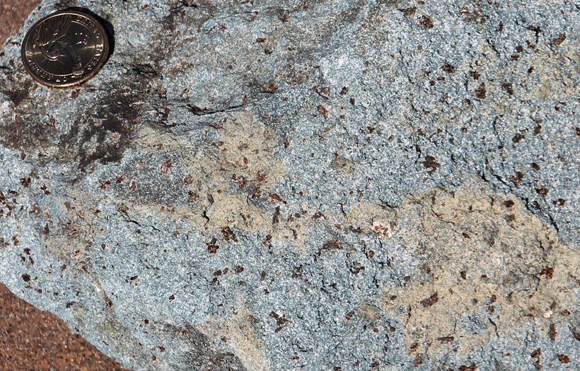
| Rocks exposed at the Silver City mine. Left – gold-colored flakes of phlogopite (mica) embedded in a fine-grained, blue-green matrix of lamproite. Right – brecciated and folded skarn in the contact-metamorphic zone next to the intrusion. Dollar coin is 1.1 inches in diameter. | 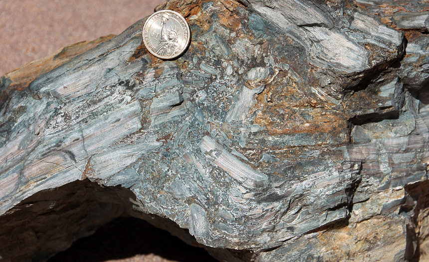
|

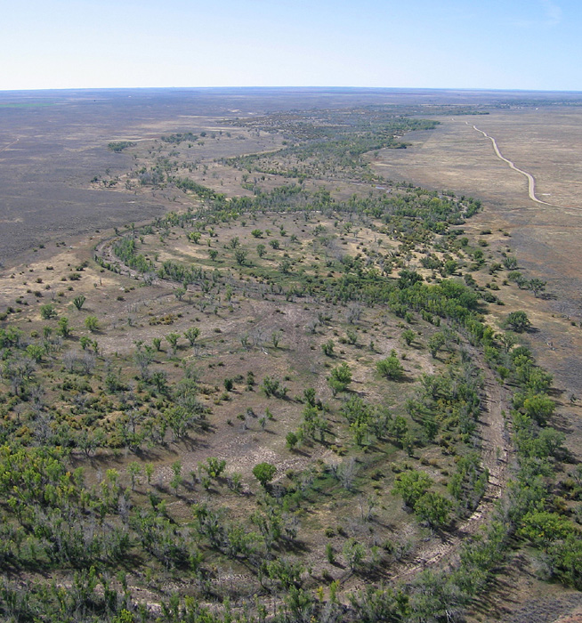
| Verdigris River valley (left) with Toronto Lake in the background. Spring view looking downstream toward the southeast in Greenwood County; kite aerial photograph. Woodson County State Fishing Lake and dam (right). Note mixed land cover with forest on steeper slopes and mowed pasture and crop fields on the upland. Helium-blimp airphoto. | 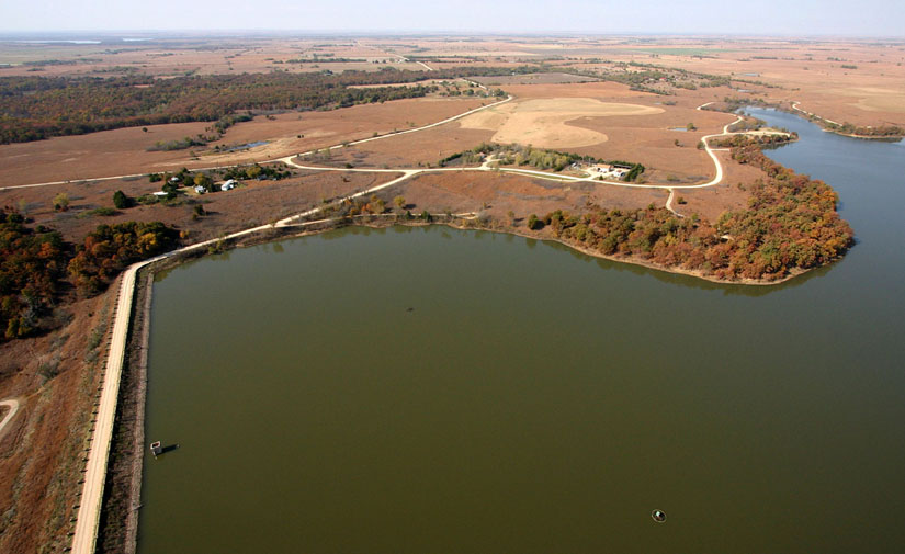
|

| Open-pit mine and processing plant at Silver City. Year by year, the mine expands as it follows the body of lamproite bedrock near the surface. Kite aerial photograph. |
Return to beginning.
 Combined references.

Return to Landscapes table of contents.
All text and images © by the authors (2022).