| Central Great Plains
Chapter I
Emporia State University Emeritus |
|
| Central Great Plains
Chapter I
Emporia State University Emeritus |
This region is the cross roads of the United States, a place of passage east-west as well as north-south. Beginning with the Lewis and Clark Corps of Discovery venture more than two centuries ago, the central Great Plains has served as a transportation corridor extending from the Missouri River westward, first with wagon trains, and then railroads, highways, pipelines, and electrical transmission lines. The central Great Plains has become a resource producing region, including oil and gas, salt, coal, and wind energy.
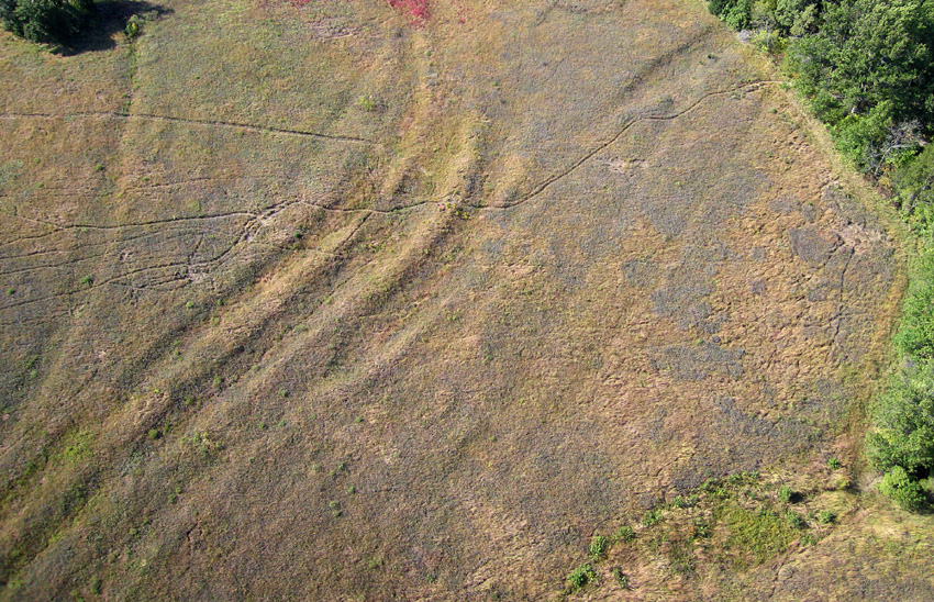
| Ruts of the Santa Fe Trail date from the mid-1800s and are preserved at Black Jack Park and Ivan Boyd Prairie, Douglas County, northeastern Kansas. Multiple, deep ruts were eroded by the passage of tens of 1000s of heavily loaded cargo wagons and hundreds of 1000s of oxen and mules to pull the wagons. Kite airphoto looking straight down in autumn; taken by ESU students. |

| Flat Ridge Wind Farm on the High Plains in Barber County, south-central Kansas. Clipper 2.5 MW turbines stand 420 feet (128 m) above the ground with the blade in the upright position. Mixed land use includes cattle grazing and fields of winter wheat. Kite aerial photograph in the early spring. |

| Liberty Memorial, Union Station and Crown Center with the Kansas City, Missouri downtown skyline in the background. The Santa Fe Trail once crossed the foreground. Helium-blimp airphoto by ESU students. |

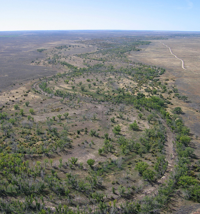
| Town of Marienthal on the High Plains in Wichita County, west-central Kansas. Nearly all the town is visible including grain elevators next to the Kansas & Oklahoma Railroad. Kite aerial photograph. |
This broad gently sloping expanse is broken in many places by conspicuous hills, ridges, valleys, and depressions of various types and sizes. Local relief exceeds 300 feet (90 m) in many of these hilly portions, such as the Flint Hills, Smoky Hills, Nebraska Sand Hills, Pine Ridge, and bluffs along deeply incised river valleys. The central Great Plains actually have surprisingly high relief and locally steep slopes in many places, far from the flat stereotype. The region is emerging, in fact, as a destination for ecotourism based on the tallgrass prairie of the Flint Hills and wetlands such as Cheyenne Bottoms and Quivira, the Platte River valley, and the Nebraska Sand Hills, as well as other natural attractions.
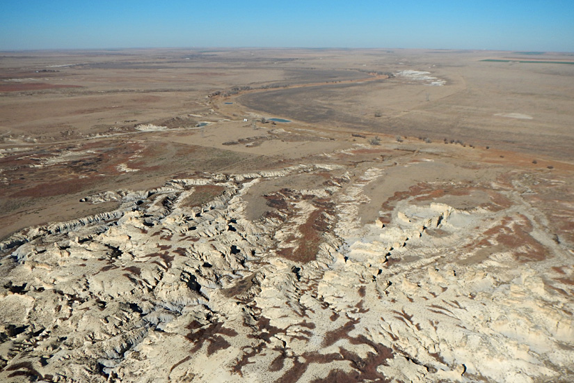
| Chalk badlands and meandering (dry) valley of the Smoky Hill River in the background. Little Jerusalem, Logan County, west-central Kansas. Kite aerial photograph. |
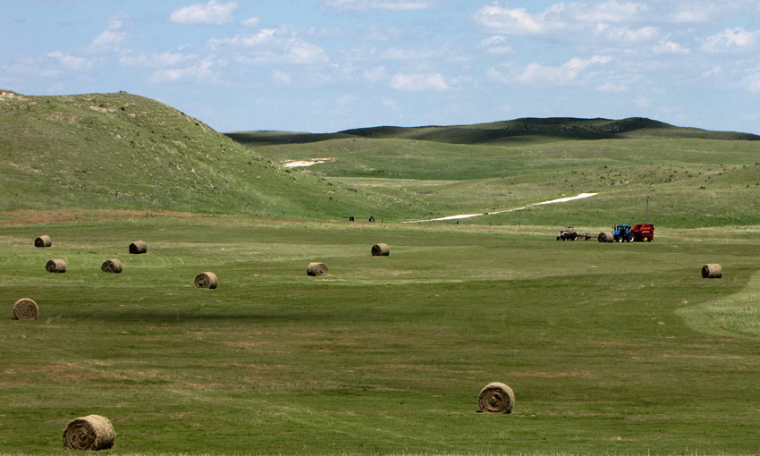
| Large sand dunes rise above well-watered valleys used for hay production. Nebraska Sand Hills, seen here near Lakeside, Sheridan County. |
 Return to beginning.
The processes that shape landforms may be categorized as endogenetic or exogenetic. Endogenetic processes are related to plate tectonics and to the surface effects of plate movements, both horizontally and vertically, as well as to other processes originating within the Earth's interior (heat flow, gravity, magnetism). Exogenetic processes develop at or above the surface in the atmosphere, hydrosphere, and biosphere. They involve wind, water, ice, mass movements, or living organisms that modify landforms. Impact of extra-terrestrial materials (meteorites, comets) are also exogenetic processes. The shape or lay of the land is conditioned by three primary geomorphic factors (Aber and Aber 2009).
• Process – refers to the physical, chemical, biological, and/or human actions that shape the surface into landforms. Broadly speaking, processes are either depositional (constructive) or erosional (destructive).
• Time – refers both to the rate at which a process modifies the surface and to the length of time or duration that a process has operated at a site.
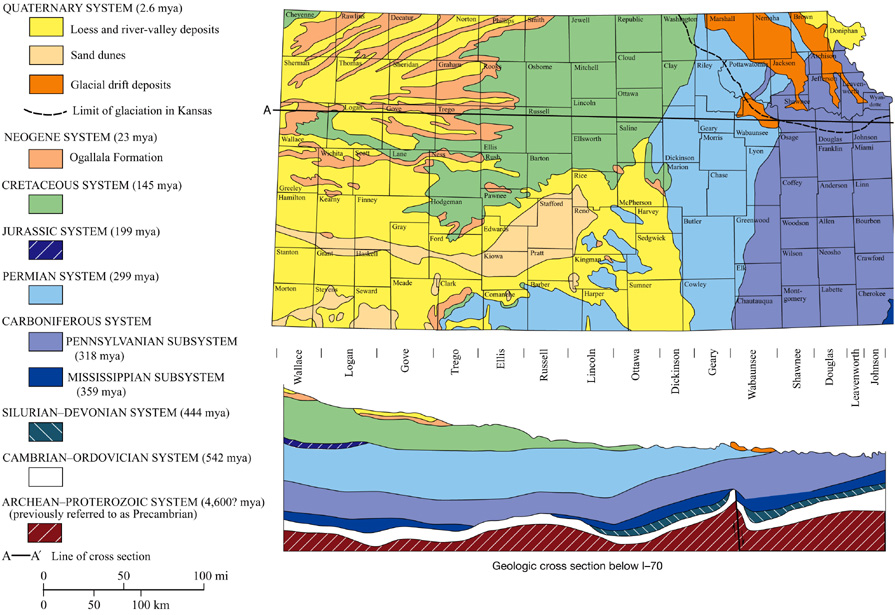
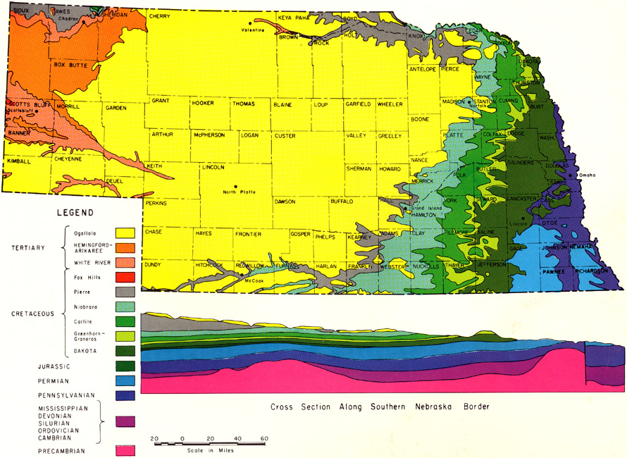
Landscapes of the central Great Plains begin with the underlying geologic foundation. Regional geology comprises a thick sequence of sedimentary layers resting nearly horizontally on ancient crystalline basement rock consisting mainly of metamorphic rocks and granite, but nowhere is this basement exposed at the surface. Sedimentary strata were deposited in various marine and terrestrial environments. These sedimentary rocks include Paleozoic, Mesozoic, and Cenozoic formations.
In general, the east is underlain by well-consolidated sedimentary rocks of Paleozoic ages, primarily Pennsylvanian and Permian. In contrast, central and western portions of the region are mostly covered by poorly consolidated to loose sediments of Mesozoic (mainly Cretaceous) and Cenozoic (Neogene) ages. The oldest bedrock exposed at the surface in the central Great Plains is Mississippian limestone (mid-Paleozoic) in the Ozark Plateau, and the youngest consolidated bedrock is the Ogallala Formation of Pliocene-Miocene age, which makes up much of the High Plains.
Wind also played a prominent role blowing sand dunes and loess (dust) in several parts of the region. Sand hills are among the youngest geomorphic features; active sand-dune development took place in central Nebraska during the middle to late Holocene only 1500-3500 years ago (Swinehart 1990; Swinehart and Diffendal 1990). The dunes are now mostly stablized by shallow groundwater and prairie grass. Thus, the older bedrock is mantled in many places by relatively young glacial, fluvial, and aeolian sediments. Most recently, human activities have altered the landscape, primarily through agriculture, transportation, mining, and the growth of cities and industry.
Many of the scenic locations in Kansas were illustrated with ground photographs by Landes (1935), and erosion of geologic landmarks was documented by Charlton and Merriam (2003), who compared historical photographs with recent pictures taken from the same vantage points. Likewise, Sherow and Charlton (2014) rephotographed the Union Pacific route across Kansas based on Gardner's 1867 photographs.
Satellite imagery gives big-picture or synoptic views of landscape assemblages, in other words the megageomorphology (Short and Blair 1986), including distinctive landforms, vegetation cover, and human land-use practices. Conventional aerial photographs provide more detailed imagery of smaller areas on the ground. Digital elevation or terrain models are datasets that portray the land surface devoid of any other features; they complement satellite images and aerial photographs.
Return to Landscapes table of contents.
Arikaree Breaks is a deeply eroded terrain underlain by thick loess (wind-blown dust) at the northern edge of the High Plains, Cheyenne County, northwestern corner of Kansas. Loess here is up to 20 m (65 feet) thick (Muhs 2010). Kite aerial photograph.

Small blow-out dunes (foreground) are superimposed on larger transverse dunes, and lakes occupy troughs between transverse dunes. Prairie grass and shallow groundwater stabilize the sand dunes. Nebraska Sand Hills in Cherry County near Valentine. Kite aerial photograph.
Return to beginning.I.3 Bird's-eye view
Based on public perception, many natural scientists and landscape photographers have overlooked the Great Plains in favor of more obvious and spectacular mountains, sea coasts, deep canyons, high plateaus, tall forests, coral reefs, etc. However, the seeming simplicity of the central Great Plains contains rich and diverse environments. Natural habitats include prairie, woodland, and wetland. From the oak forest along the rugged Missouri River bluffs to playas, shortgrass prairie, and conifer forest of the High Plains, the region spans major environmental transitions.


Castle Rock, a well-known chalk monument in Gove County, west-central Kansas. Photographs taken from the same ground vantage point in 1941 (left), 1997 (middle) and 2001 (right). Rapid disintegration and collapse of the chalk columns are obvious. Adapted from Charlton and Merriam (2003, figs. 4-6).

Digital orthophoto quadrangle (DOQ) derived from conventional black-and-white aerial photograph showing a portion of the Gray County Wind Farm, southwestern Kansas. Wind turbines are placed along east-west field boundaries. Dataset obtained from the U.S. Geological
Survey, EROS Data Center.
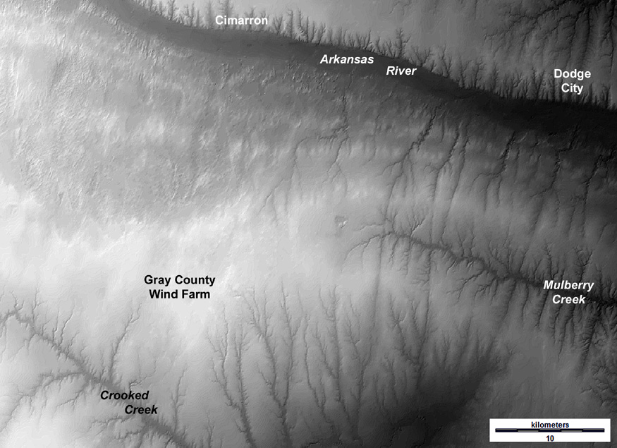
Shaded-relief digital elevation model for the Gray County Wind Farm vicinity. Elevations range from less than 750 m (darkest gray) to above 850 m (white). The wind farm is located on the drainage divide between the Arkansas River and Crooked Creek at elevations 850-860 m (~2800 feet). Elevation dataset obtained from U.S. Geological Survey.

Gray County Wind Farm, the first large wind-energy array in Kansas, began operation in 2001. Vestas V47 turbines stand 295 feet (90 m) tall to the tip of upright blades. Green fields are winter wheat on the High Plains upland. Early spring view; kite aerial photograph (Aber and Aber 2012).

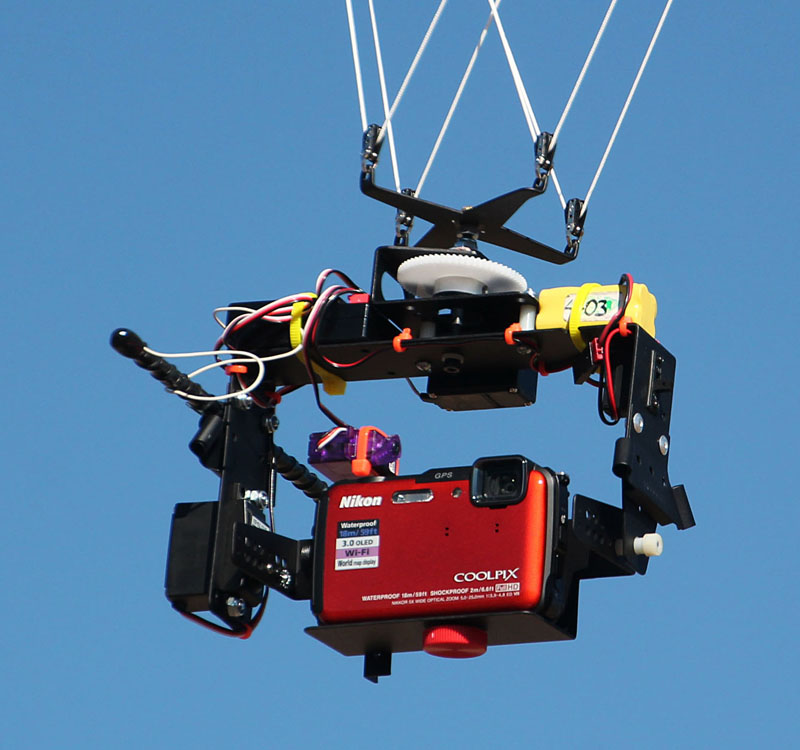
Kite aerial photography. Large delta kite (left) with 19-foot wing span and 20-foot tail. Camera rig (right) hangs from the kite line and is operated by radio-control from the ground.
 Return to beginning.
I.4 Landscapes of the central Great Plains
From the glaciated district of the northeast to the High Plains on the west, the central Great Plains contain a rich variety of geologic and geographic features, which were recognized by early explorers and geologists. Louis Agassiz took a trip in 1868 across the western plains region, including Kansas, Nebraska, and other states. He was perhaps the most famous scientist to have visited the central Great Plains at that point in time. He found unmistakable evidence for glaciation and recognized that the Missouri River valley had originated for drainage of glacial meltwater, which proved to be a highly significant observation (Aber 1984). Since then, many others have investigated, described, and mapped the geomorphic and physiographic features of the region (e.g. Haworth 1896, 1897; Adams 1902; Schoewe 1949; Stout et al. 1971; Wilson 1978).
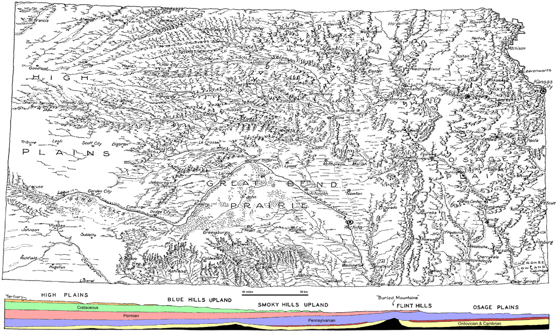
Surface features of Kansas showing the major landscape regions and underlying geologic cross section. The map notes the High Plains, Blue Hills Upland, Smoky Hills Upland, Great Bend Prairie, Flint Hills, Osage Plains and Cherokee Lowland. Adapted from Moore (1930).
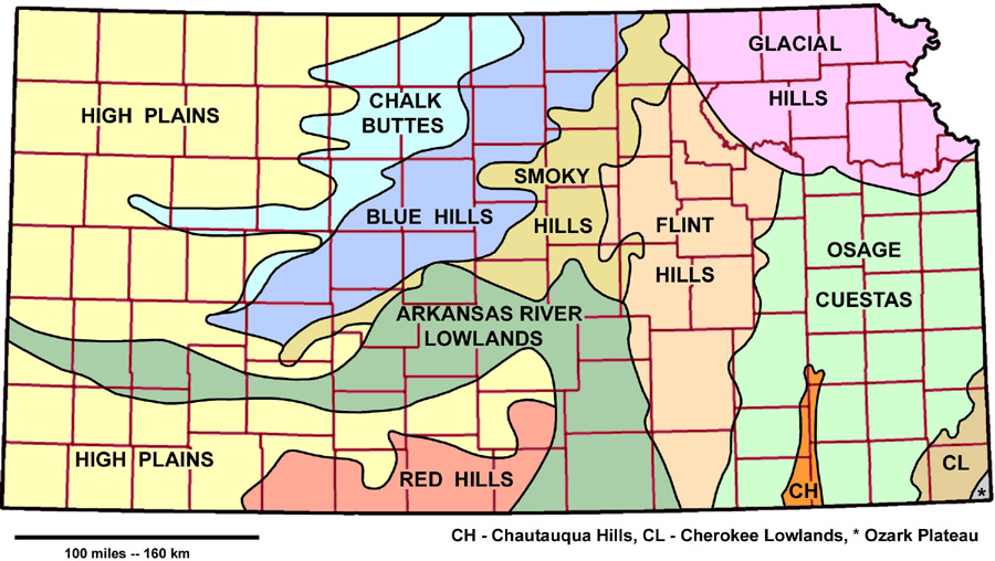
Landscape regions of Kansas according to Aber and Aber (2009). Based generally on Schoewe (1949) and Wilson (1978) with modifications of some region boundaries and names. Region limits are sharp and well defined in some cases, but may be transitional or gradual in other places. County boundaries shown in maroon.
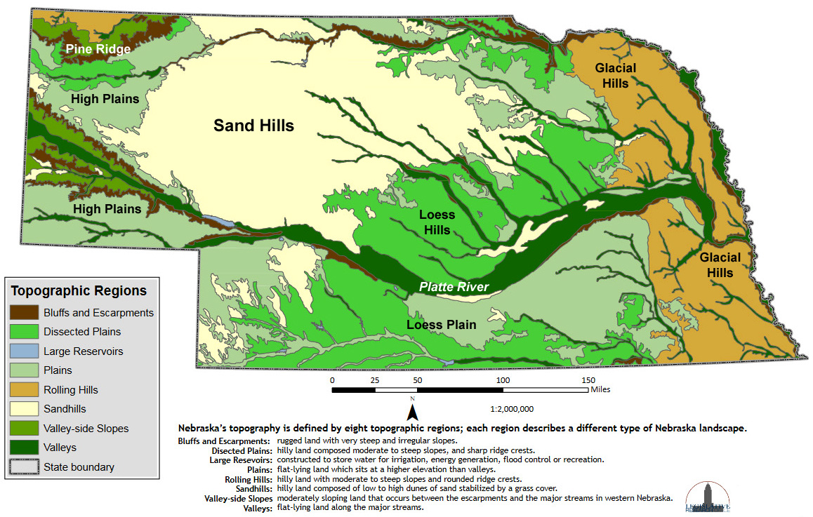
 Landscape regions of the central Great Plains
Summary of characteristicsRegion Geomorphic
agents Bedrock age
and type Surficial
sediment Landforms Relief
High Plains water, wind Neogene silt, sand,
gravel, mortar beds loess, sand,
valley alluvium broad, flat plain
sand dunes low to high
Pine Ridge water Neogene silt, sand,
gravel, mortar beds alluvium in
valleys escarpment,
rugged hills high
Nebraska
Sand Hills wind, water Neogene silt, sand,
gravel, mortar beds sand large and small
dunes, swales moderate
to high
Arkansas and
Platte valleys water, wind,
meltwater Quaternary silt,
sand, gravel alluvium,
sand, loess dunes, channels,
floodplains low
Red Hills water Upper Permian
red beds, gypsum alluvium in
valleys buttes, sinkholes,
natural bridges moderate
Chalk Buttes water Upper Cretaceous
chalk, limestone alluvium in
valleys, loess buttes, gentle
hills, badlands moderate
to low
Blue Hills water Upper Cretaceous
shale, limestone alluvium in
valleys escarpment,
gentle hills high to low
Smoky Hills water Lower Cretaceous
shale, sandstone upland gravel,
valley alluvium rugged hills
and plains moderate
to low
Flint Hills water Permian shale,
limestone, chert upland chert,
valley alluvium escarpments,
rugged hills high to
moderate
Glacial Hills ice sheet, wind,
meltwater Penn. and Permian
Lower Cretaceous till, loess, clay,
sand and gravel spillways and
buried valleys high to
moderate
Osage Cuestas water Pennsylvanian shale
limestone, sandstone valley alluvium,
upland gravel escarpments
and cuestas moderate
to low
Chautauqua
Hills water Pennsylvanian
sandstone, shale alluvium in
valleys rugged hills high
Cherokee
Lowlands water Pennsylvanian coal
sandstone, shale alluvium in
valleys flat plain low
Ozark Plateau water Mississippian
limestone, chert alluvium in
valleys plateau moderate
Return to beginning. Combined references.
All text and images © by the authors (2022).