| Central Great Plains
Chapter IX
Emporia State University Emeritus |
|
| Central Great Plains
Chapter IX
Emporia State University Emeritus |
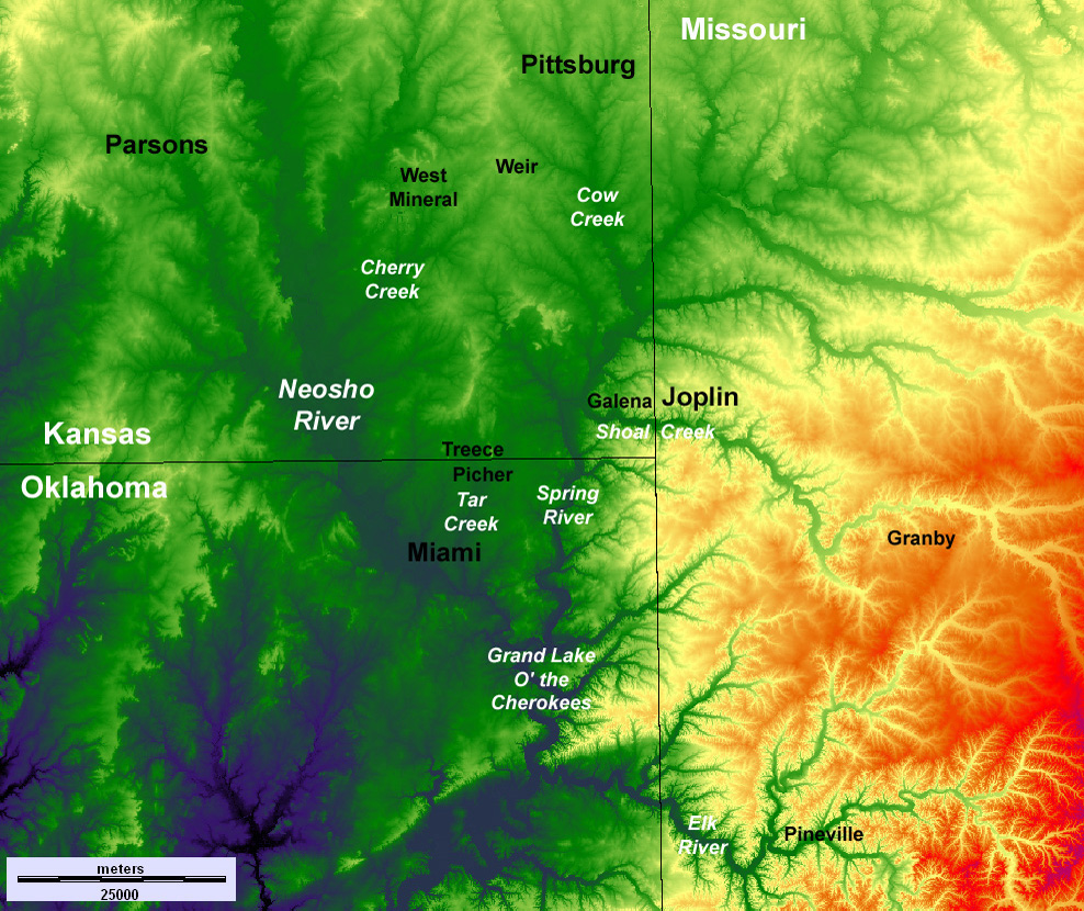 Topographic map of the Tri-state district showing selected cities and rivers. Elevations range from less than 200 m (dark blue) to more than 400 m (red). Derived from digital elevation data of the EROS Data Center, U.S. Geological Survey. Taken from Aber et al. (2010).
| |
 Return to beginning.
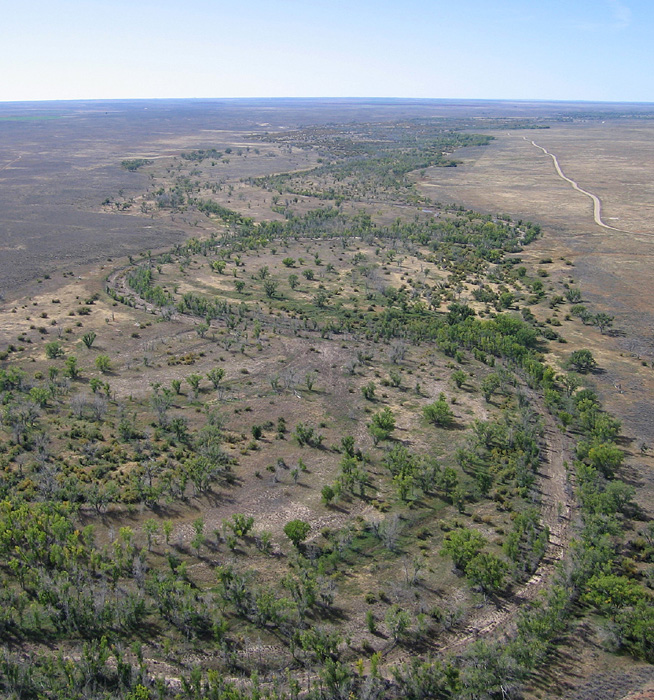
| Left – view toward the northwest near West Mineral in Cherokee County. The flat landscape is quite apparent. Water channels in center distance are reclaimed mined land. Blimp airphoto by ESU students. Right – small exposure of the Warner Sandstone Member of the Cherokee Group. | 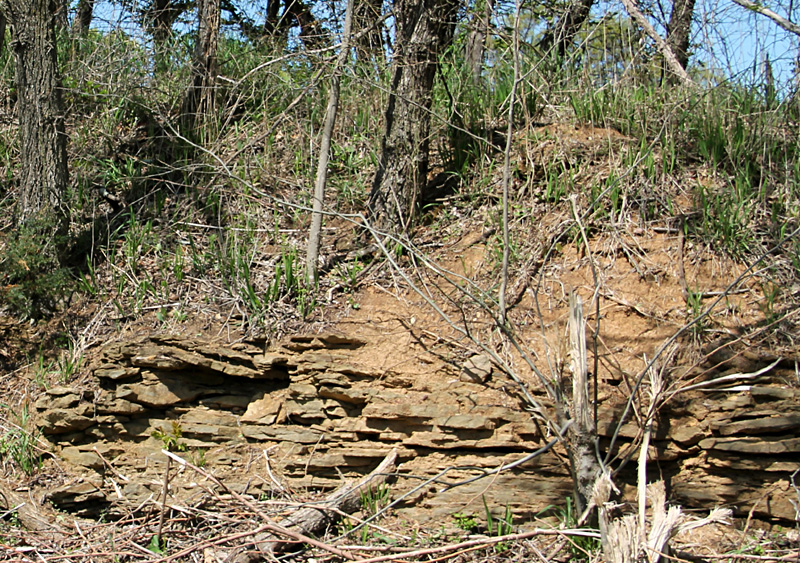
|
Kansas coal mining commenced in 1827 in connection with the founding of Fort Leavenworth. The scope of mining expanded dramatically in the 1870s to supply fuel for railroad steam locomotives and for smelting lead and zinc ores. Both surface and underground mining took place in the Cherokee Lowlands. Underground coal mines also were operated in Leavenworth and Osage counties to the north and northwest. Kansas coal production reached a peak early in the twentieth century. Underground mining ended in the late 1950s, but open-pit mining continued in the Cherokee Lowlands until late in the twentieth century. The last coal mine in Linn County finally closed in 2016.
Among several coal beds, the Weir-Pittsburg is thickest at 3-5 feet (1-1˝ m); it was mined extensively in Cherokee and Crawford counties (Brady and Dutcher 1974). Most of the other coal seams are less than 3 feet (1 m) in thickness. Big Brutus, a huge electric power shovel that operated in the Pittsburg and Midway open-pit mines in Cherokee County during the 1960s and 1970s, is an iconic symbol of Kansas coal mining. Approximately 40,000 acres (~16,000 ha) of land were strip mined in Crawford and Cherokee counties.
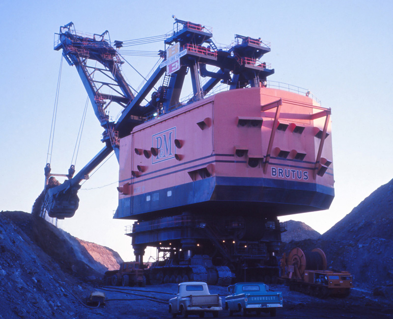
| Big Brutus stands 160 feet tall with a working weight of 5500 tons. Left – seen here in action at a Pittsburg and Midway (P&M) coal mine in southeastern Kansas. Photograph courtesy of L.A. Ward (1966). Right – restored and on display for the public near West Mineral, Kansas. Vertical view with silhouette shadow. Note smaller power shovel and bulldozer at bottom for scale. Helium-blimp airphoto; adapted from Aber and Aber (2009). | 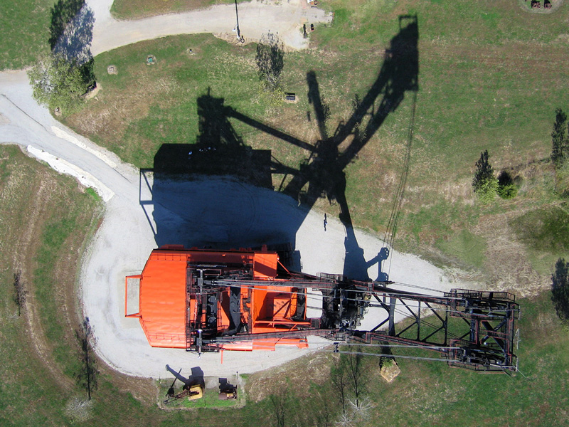
|
Prior to 1969, mined land was abandoned and left to overgrow with brush and trees. As an experiment, trees were planted on several thousand acres of mined land in northwestern Cherokee County in the late 1930s (Muilenburg 1961). Similar revegetation was done in Crawford County, and these sites are now wildlife refuges known for excellent deer hunting and fishing.
Acid water leaching from waste mining debris, known as gob piles, has polluted surface and groundwater. Contaminated soils may contain arsenic, manganese, and iron and have acidity equivalent to vinegar (pH 2-3) (Bechtold, et al. 2020). Cow and Shawnee creeks are seriously impacted; in Cherry and Little Cherry creeks only the most acid-tolerant organisms have survived (Aruda 1992). Since 1969, state law requires that mined land must be reclaimed for productive agricultural use. The land must be returned to rolling terrain with pasture for grazing or tree cover.
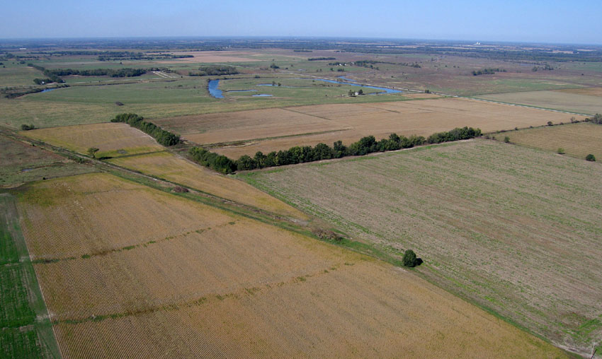
| Cow Creek (left) in the foreground and the city of Pittsburg in the background. Cow Creek is seriously polluted with runoff from mined-land west and north of Pittsburg. Kite aerial photograph. Overview near West Mineral (right). Reclaimed mined land is marked by pastures and water channels on left and across the background. Unmined cropland appears to right side. Blimp airphoto by ESU students. | 
|
Groundwater is produced from alluvial aquifers of the river valleys as well as the Ozark Plateau aquifer system comprised of the Springfield Plateau and Ozark aquifers. This system consists mainly of limestone and dolostone of Mississippian, Ordovician and Cambrian ages that crop out in the Ozark Plateau of southwestern Missouri and the extreme southeastern corner of Kansas. The bedrock dips westward beneath the Cherokee Lowlands, where the aquifer becomes confined. In the early 21st century, however, both quantity and quality of water from this aquifer have declined, because of increasing regional demand and surface pollution in the recharge area to the east.
Return to beginning.
| Early autumn view eastward over Shoal Creek at Schermerhorn Park, south of Galena, Kansas. Forest-covered limestone bluff and upland to left; alluvial bottomland to right. Helium-blimp airphoto by ESU students. |
In the Tri-state region , the Ozark Plateau consists primarily of Mississippian strata including limestone, cherty limestone, and chert. Prominent formations include the Warsaw, Burlington-Keokuk, and Reeds Spring-Elsey; Mississippian strata total about 300 m (~1000 feet) in aggregate thickness in southwestern Missouri (Thompson 1995). These units are subject to considerable lateral facies changes, especially in regard to chert content. As the limestone has dissolved over millennia, chert and insoluble clay have accumulated at the surface to form leached, acidic, relatively infertile soils.
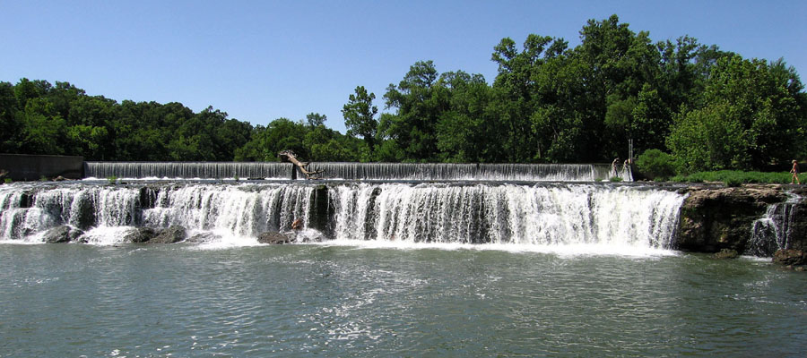
| Grand Falls (left) on Shoal Creek, Joplin, Missouri. The creek cascades over resistant beds of Mississippian limestone and chert. Mississippian limestone (right) overlain by several m of residual chert and clay in the Ozark Plateau upland near Pineville, McDonald County, Missouri. Both photos from (Aber et al. 2010). | 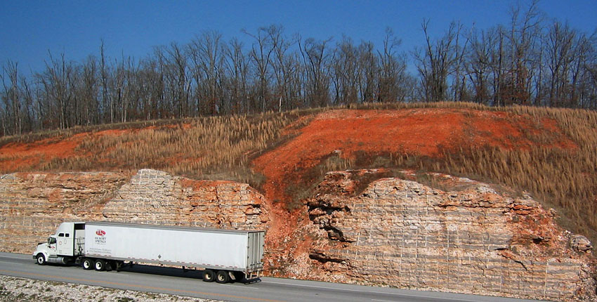
|
The region is drained by Spring River and its main tributary Shoal Creek, which carry clear water over chert gravel beds. Caves, springs, and other karst features are commonplace. The larger caves are found in the Keokuk Limestone at or near the level of valley bottoms (Young and Beard 1993), as at Schermerhorn Park on Shoal Creek, south of Galena.
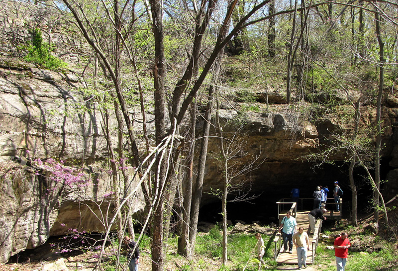
| Entrance to cave in the Keokuk Limestone, Schermerhorn Park, south of Galena, Kansas. Photograph taken during a field trip of the Geological Society of America (2010). |
Water quality in Spring River and its tributaries is heavily impacted by runoff from abandoned mines, agricultural activities, and municipal wastewater discharge (Aruda 1992). Empire Lake, dammed at the confluence of Spring River and Shoal Creek, provides cooling water for a gas-fired electric power plant at Riverton, Kansas. Substantial sedimentation has taken place in the lake, and it appears to be a sink for pollution derived from upstream (Chambers et al. 2005).
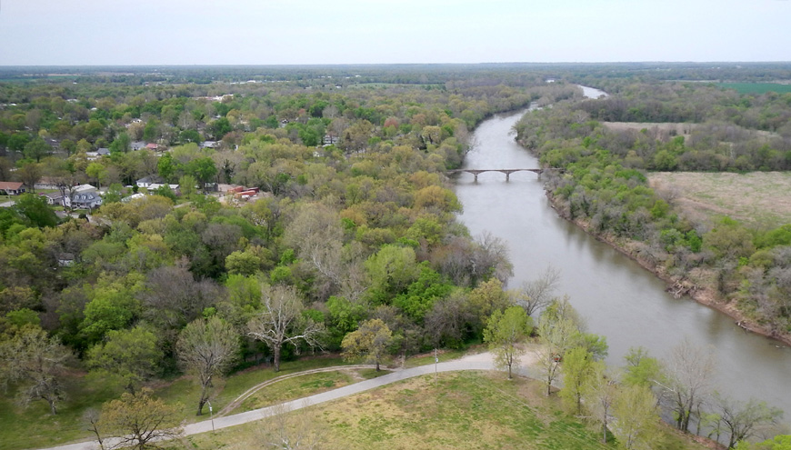
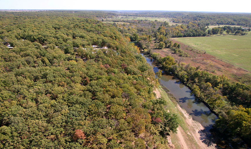
| Looking northward along the Spring River, which marks the boundary between the Cherokee Lowlands to the west (left) and Ozark Plateau to the east (right). Baxter Springs, Kansas to left; old railroad bridge over the river is no longer used. Note the low topographic relief and nearly flat horizon. Kite photograph in early spring. |
Return to beginning.
Primary ore minerals were galena (PbS), which is the Kansas state mineral, and sphalerite (ZnS). Smithsonite (ZnCO3) was also a locally important ore. Chalcopyrite, pyrite, marcasite, bornite, and covellite are other sulfide minerals often found in the ore veins. Some 60 valid minerals are known, in fact, from the TSMD including quartz, aragonite, calcite, dolomite, and copper-bearing minerals such as azurite, chrysocolla, cuprite, and malachite (Aber et al. 2010).
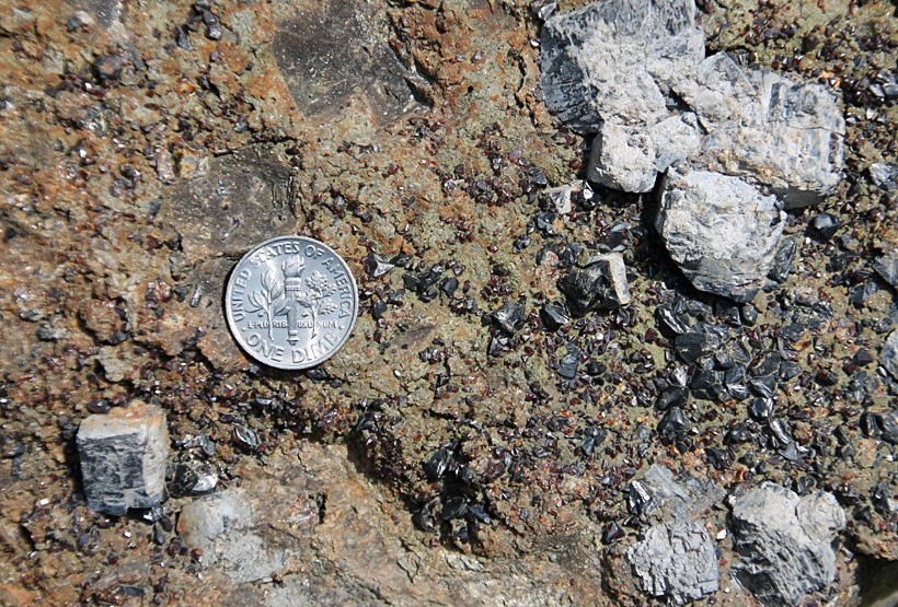
| Typical lead-zinc ore from the Tri-state Mining District. Large gray cubes are galena, and smaller black to red-brown crystals are sphalertie set on a matrix of quartz and chert. Dime coin for scale. |
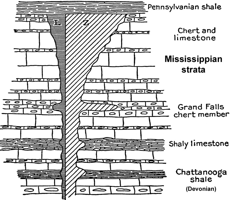 Diagram of lead-and-zinc ore distribution within Mississippian strata of the Tri-state Mining District. The quantity of ore increases upward and reaches its maximum within the Grand Falls chert member and just below Pennsylvanian strata. The relative proportion of lead (L) and zinc (Z) minerals is indicated schematically. Sketch not to scale; adapted from Siebenthal (1915).
| |
Smelting of lead and zinc ore took place where fuel was abundant. Three to four tons of coal were necessary to process one ton of zinc ore; thus, it made sense to take the ore to the fuel rather than the other way. Although some of the ore was smelted near the mines, most was transported out of the region for smelting where fuel was abundant—coal at Pittsburg and natural gas at Iola, Kansas, and later Bartlesville, Oklahoma.
In 1914 larger, deeper, and richer ore deposits were discovered at Picher, Oklahoma and nearby Treece, Kansas. Nearly all mining took place in this vicinity after 1920, and additional major deposits were found after 1925. During the Great Depression, many small companies were consolidated into a few larger companies, and by 1950 the Eagle Picher Company controlled more than half of all production in the district. After World War II, production gradually declined. Larger mines had ceased operating by 1957; the last small mines were closed in 1970. Total estimated lead and zinc production from the TSMD was nearly 12 million tons.
| State | Lead | Zinc | |||||||||
|---|---|---|---|---|---|---|---|---|---|---|---|
| Total production of lead and zinc by state and overall for the TSMD. Years of mining given for each state; values in thousands of short tons. Data from Park (2005). |
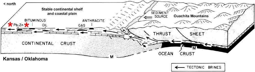 Schematic diagram showing simplified thrusting of the Ouachita Mountains northward onto stable continental crust of the mid-continent region during the Pennsylvanian Subperiod. Migration of tectonic brine in the subsurface was responsible for Pb-Zn mineral deposits (*) in the TSMD. M – Mohorovicic discontinuity, the crust/mantle boundary. Diagram adapted from Oliver (1986).
| |
Return to beginning.
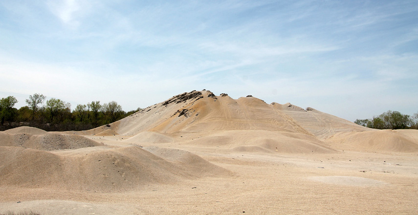
| Chat piles are a legacy of former lead-and-zinc mining. Overview (left) and detail of chat (right). Chat is the waste product from mining, crushing, and separating lead-and-zinc ore. Chat consists mainly of chert fragments and is contaminated with lead, zinc and cadmium. Near Treece, Kansas; comb for scale is 5 inches long. | 
|
At the close of mining in the 1970s, more than 500 million tons of chat were left; more than three-fourths of this waste now has been removed, but ~100 million tons of chat remain in the Tri-state area (EPA 2007). Open shafts and collapsed mines littered the landscape along with derelick processing plants.

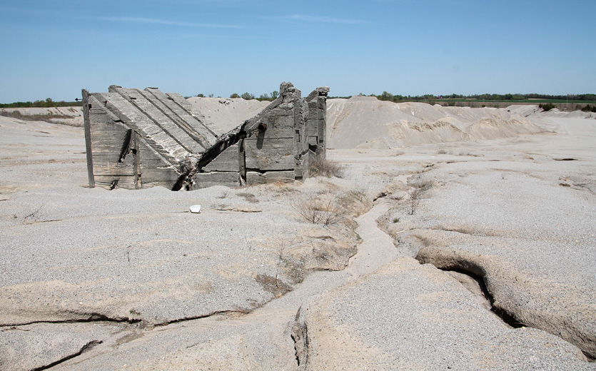
| Hell’s half acre, a barren and devastated landscape covered by chat and potholed with open shafts and collapsed mines. Immediately west of Galena, Kansas as it appeared in 1992. This vicinity was remediated since this photograph was taken. |
The chat piles, water-filled mines, and former smelting sites are today sources for highly polluted water that contains heavy metals. In addition to lead and zinc, mining byproducts included cadmium, germanium, and gallium (Park 2005). Streams, lakes, and shallow aquifers of the TSMD are contaminated, and past coal mining in the Cherokee Lowlands also contributes to significant local and downstream water pollution in the region (Arruda 1992).
Such contamination led to establishment of Environmental Protection Agency (EPA) superfund sites in Missouri, Kansas, and Oklahoma beginning in the early 1980s. Land collapse and lead poisoning, especially for children, were special concerns. To a large extent, the former mining areas around Joplin and Galena have been reclaimed. Chat piles were removed and the material used for concrete and construction aggregate, pits and sinkholes were filled in, and the land covered and revegetated. Nonetheless, several old mines collapsed beneath Galena between 2006 and 2009, which demonstrates the geologic hazards of past mining for the city.
The Picher vicinity, including nearby Cardin, Oklahoma and Treece, Kansas, experienced the deepest and most thorough mining of any portion of the TSMD, primarily in the early and mid-twentieth century. Large chat piles accumulated within and around Picher, Treece, and nearby mining communities, and mine water was pumped at rates up to 50,000 m3 per day (Reed et al. 1955).
Soon after active mining ended and mine-water pumping ceased, metal-laced mine water began discharging naturally in 1979 through open mine shafts, springs, and artesian wells of the vicinity. Initial mine-water discharges were highly acidic; however, the water chemistry is now net alkaline. This discharge continues today, and dust from exposed chat piles blows over the surrounding landscape.
Among the most severely impacted streams is Tar Creek, which drains the Picher-Cardin-Treece vicinity. According to the U.S. Army Corps of Engineers, Tar Creek is highly toxic and, for all intents and purposes, dead (USACE 2005). Tar Creek is ranked among the top ten most endangered streams in the United States (American Rivers 2021).
| Tar Creek pollution. Left – abandoned chat pile and mine ruin near Treece, Kansas. Gullies show the pile is actively eroding directly into Tar Creek. Right – typical rust-orange color at low flow. View downstream just east of Commerce, Oklahoma (Aber et al. 2010). | 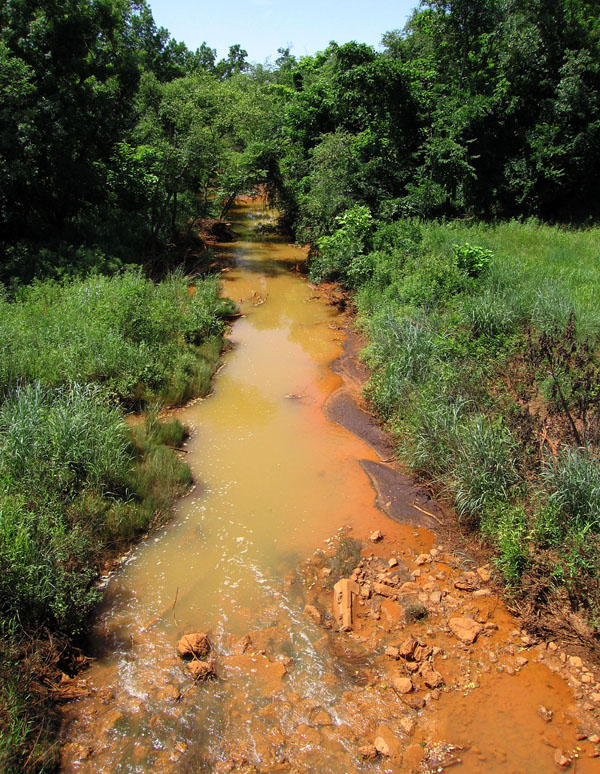
|
Quapaw Native Americans live in the Picher vicinity and own much of the ruined land. Past policies of the Bureau of Indian Affairs (BIA) exacerbated the pollution problems (USACE 2005). The situation began in the 1870s when BIA forced the Quapaws to lease their land to mining interests. Lead-and-zinc mining commenced in 1891 and continued until 1970. BIA policy required mining companies to leave chat piles on the land, because the chat might be of economic value. Thus, enormous chat piles accumulated during decades of mining, and many remain to this day.
To add further misery to this situation, an EF-4 tornado struck Picher on May 10, 2008. Six people died, and 20 city blocks were destroyed by the mile-wide twister. Both Picher and Treece have been closed officially by the EPA, as clean-up and reclamation efforts continue. Joplin, Missouri then was struck on May 22, 2011 by a massive EF-5 multiple-vortex tornado that cut a path up to a mile wide and several miles long across the southern portion of the city. At the time, it was the single deadliest and most costly tornado in the U.S. since 1950 when official record keeping began (NIST 2021).
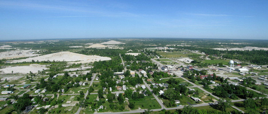 Overview of Picher, Oklahoma in the foreground and Treece, Kansas in the far right background. Large chat piles are scattered across the scene. Taken one year after an EF-4 tornado struck Picher in 2008 and destroyed much of the city. Panorama assembled from two helium-blimp airphotos.
| |
Return to beginning.
 Combined references.

Return to Landscapes table of contents.
All text and images © by the authors (2022).