| Central Great Plains
Chapter VII
Emporia State University Emeritus |
|
| Central Great Plains
Chapter VII
Emporia State University Emeritus |
 Landscape maps.

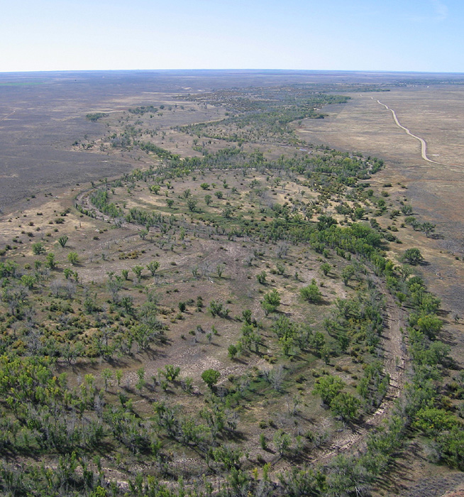
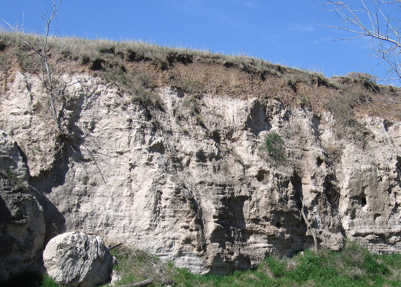
| Overview of glaciated uplands in central Jefferson County, Kansas. Mixed agricultural land use and patchy forest cover are characteristic. Lake Perry, a large man-made reservoir, is visible in the background. The lake is situated in the Delaware River valley, which was formed by meltwater erosion as a glacial spillway channel. Helium-blimp airphoto. |
The terms Nebraskan and Kansan were applied respectively to the presumed oldest and second-oldest glaciations of the region (Chamberlin 1895), and this simple stratigraphy was generally accepted through the middle of the twentieth century (Frye and Leonard 1952). But much debate and controversy surrounded the exact definitions and meanings of these terms, so the names have been abandoned for modern stratigraphic use (Hallberg 1986).
 Return to beginning.
In general, till is closely similar in composition to local bedrock. This resulted in clay-rich till derived from abundant shale bedrock. Till also contains anything and everything over which the glaciers advanced on their way southward. Most noticeable are erratic boulders transported from far-distant bedrock sources. Most of these are Sioux Quartzite carried from outcrops in southwestern Minnesota and adjacent South Dakota and Iowa. Pipestone, a distinctive soft, blood-red rock carved by Native Americans to make smoking pipes and ceremonial objects, comes from the same source area. Granite, gabbro, gneiss, greenstone, schist, ironstone, and many other crystalline erratics were transported from the Canadian Shield even farther to the north. Among the most unusual till components are well-preserved fragments of spruce wood, some as large as fence posts.

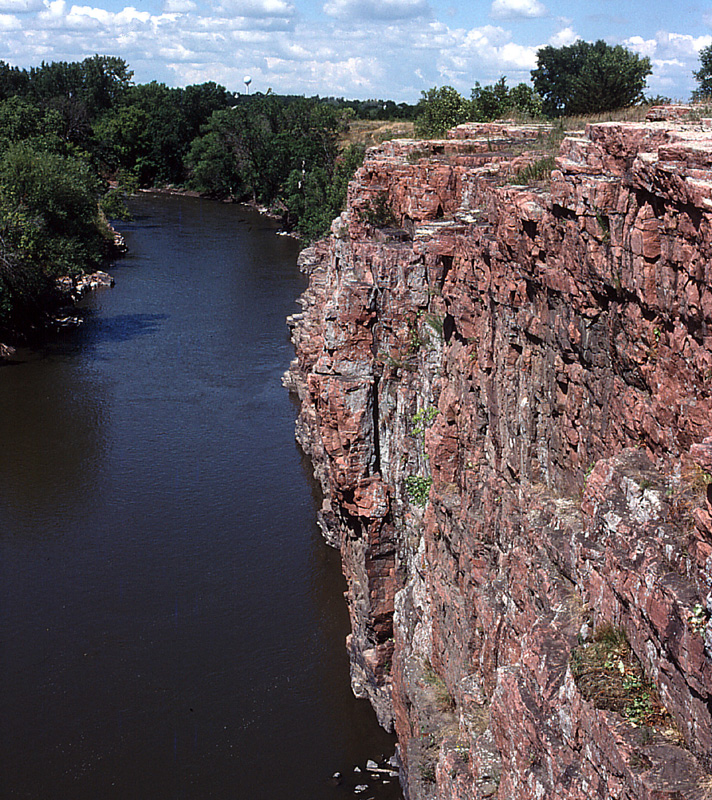
| Sioux Quartzite (left) displays typical reddish pink color where exposed in the channel of Split Rock Creek, Palisades State Park, eastern South Dakota. Erratic boulder of Sioux Quartzite (right) near Meriden, Kansas. Scale pole marked in feet. | 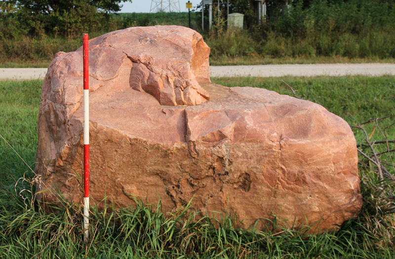 |
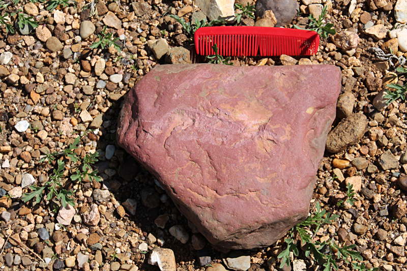
| Pipestone (left) is a soft, blood-red rock that came from the same source area as Sioux Quartzite in southwestern Minnesota. Greenstone (right) is a low-grade metamorphic rock derived from the Canadian Shield. Both specimens near Marysville, Kansas. Comb is 5 inches long. | 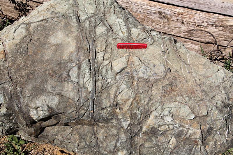 |

| Gray till (left) was deposited directly from the base of a glacier, and buff-colored sand accumulated in a proglacial lake. Both were strongly sheared and folded by subsequent glacier overriding. Near Wathena, Kansas; scale pole marked in feet. Wood (right) preserved in the lower gray, clay-rich till of the Cedar Bluffs section on the Platte River near Fremont, Nebraska. | 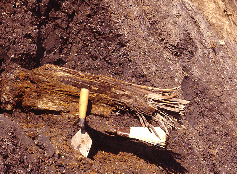
|
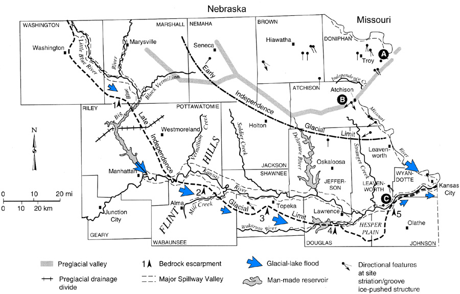 Glaciation of northeastern Kansas by two advances of the Independence ice sheet. Key sites for stratigraphy and dating: A – Wathena, B – West Atchison, C – De Soto. Bedrock escarpments (1-5) held up the maximum limit of glaciation, which spread farther south in lower areas between escarpments. Based on Aber (1991); adapted from Denne et al. (1998).
| |
| Excavating bouldery gravel (left) from an infilled meltwater channel near Marysville, Kansas. Former sand-and-gravel pit (right) in glacial outwash near Menoken in the Kansas River valley. Cross-bedded sand and gravel with cemented zones at the top. Both sites required high-velocity meltwater flow to transport and deposit bouldery sediment. | 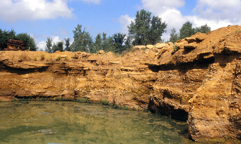
|
| Glacial meltwater spillway channel (left) eroded into massive Sioux Quartzite at Dell Rapids, South Dakota. Sketch map (right) of drainage in eastern Nebraska. Eastward of the Big Blue River and North Fork Elkhorn River most streams follow ice-marginal routes. Adapted from Wayne (1985). | 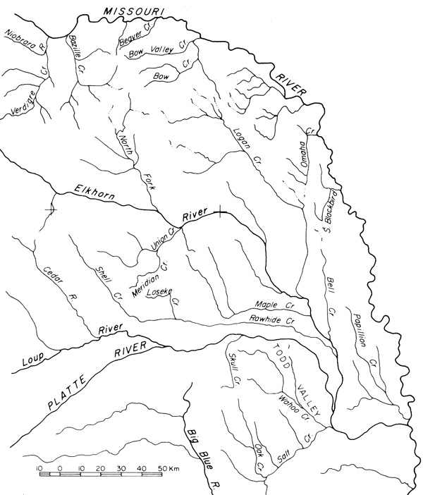 |
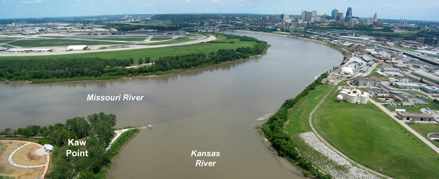 Overview eastward from Kaw Point at the confluence of the Missouri and Kansas rivers. Both valleys were carved as meltwater spillways during the Independence Glaciation. Skyline of downtown Kansas City, Missouri in the right background. Panorama assembled from two helium-blimp airphotos taken on the Lewis-and-Clark bicentennial (2004).
| |
A partially filled spillway valley crosses the central portion of Kansas City, Missouri, for instance. This valley is an eastward continuation of Turkey Creek valley. Union Station is located in this valley, and railroads follow the valley from the West Bottoms of the Kansas River valley eastward to the Missouri River valley. The valley is filled with as much as 200 feet (60 m) of sand and gravel. The valley functioned as a meltwater spillway when the ice margin lay across modern downtown Kansas City, Missouri. The Missouri River valley was blocked, and upstream meltwater from the Kansas River valley overflowed and eroded a series of outlet channels. Similar meltwater valleys are located east of Independence, namely the Missouri–Little Blue–Buckner valley (McCourt 1917).
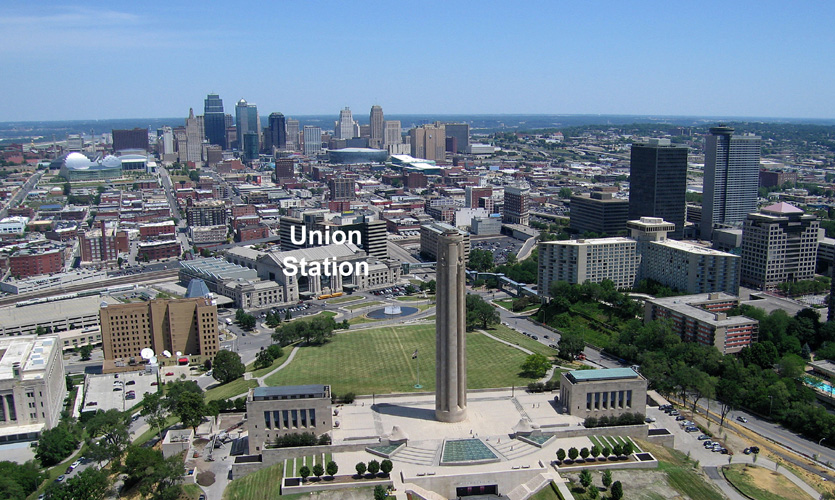
| Liberty Memorial (foreground) and downtown skyscrapers (background) are built on bedrock. But the Union Station is located on a buried valley with up to 200 feet (60 m) of sand-and-gravel fill. This partly filled valley provided a favorable route for construction of railroads connecting the Missouri River valley with the Kansas River valley. View northward; helium-blimp airphoto by ESU students. |

| Glacial deformation of upper Pennsylvanian bedrock. Left – limestone blocks are tilted and stacked over each other with glacial gravel packed under and between the blocks. Scale pole marked in feet; near Topeka, Kansas. Right – folds in deformed limestone and shale. A - Winterset Limestone Member and B - Stark Shale Member of the Dennis Limestone; C - Galesburg Shale. South-central Iowa; photo courtesy of L.F. Dellwig. | 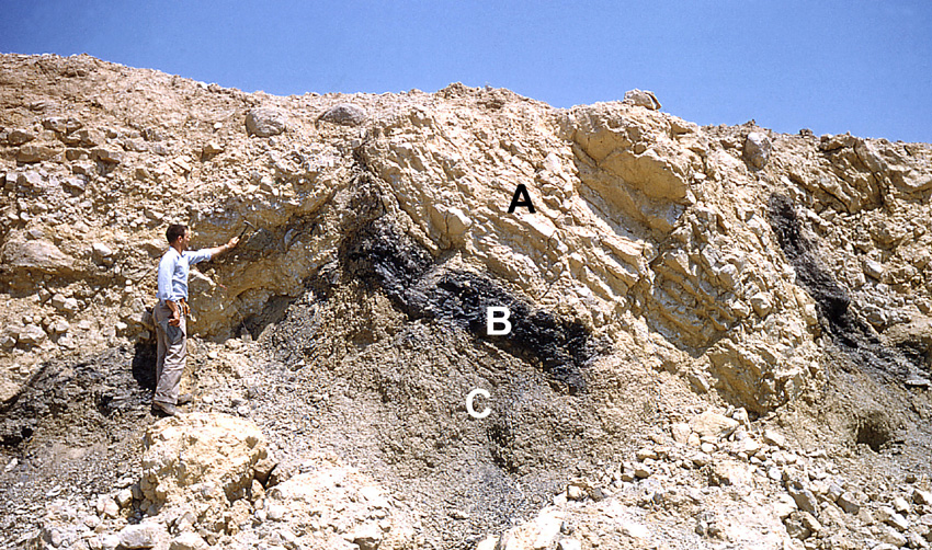
|
| Loess on the bluff above the Missouri River valley at White Cloud, Doniphan County, Kansas. Overview (left) and detail shot (right). Note the well-preserved gastropod shells in the late Pleistocene sediment. | 
|
Return to beginning.
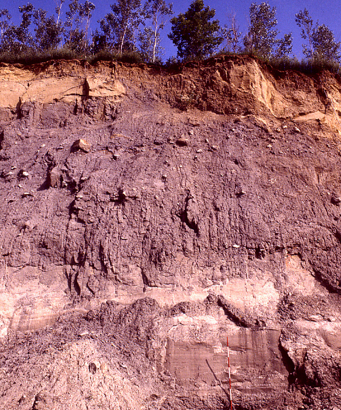
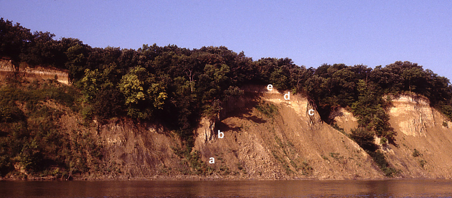 Bluff section exposed on the Platte River near Fremont, Nebraska. From the bottom up: a) lower gray till, b) middle brown till, c) upper tan till, d) red paleosol, and e) loess cap.
| |
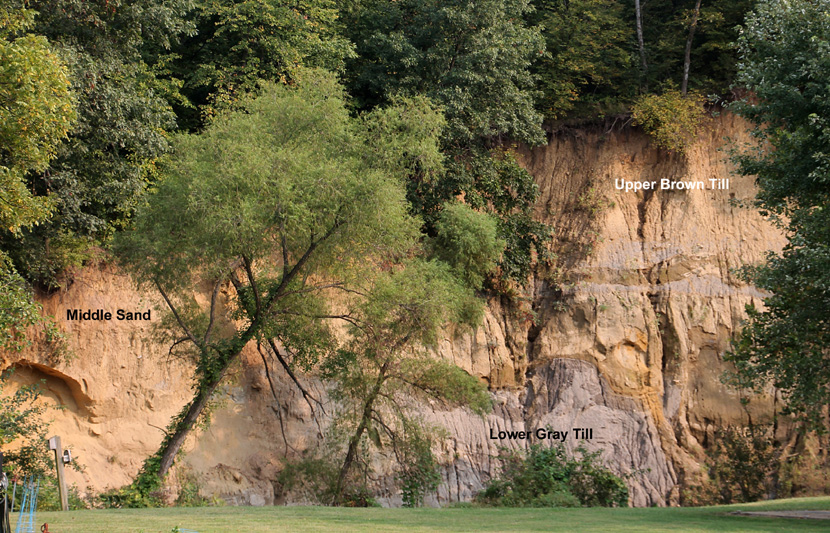
All glacial and glacially related deposits in northeastern Kansas now are referred to the Independence Formation, named for Independence Creek in Atchison and Doniphan counties (Aber 1991). The stratotype for this formation is an exposure on White Clay Creek in western Atchison. The section consists of a lower gray till, a middle sand unit, and an upper brown till. The lower gray till contains abundant wood. This till is lithologically similar to the lower till at the Cedar Bluffs section in Nebraska and to the lower till in the McCredie Formation across north-central Missouri; all contain common inclusions of wood. In Kansas, this till is associated with directional features (striations, till fabrics, ice-pushed structures) that indicate ice movement from the northeast. The farthest southern extent of the early Independence ice advance appears to be northernmost Leavenworth County (see map above).
| Independence Formation stratotype, West Atchison, Kansas. Overview (left) as seen from US 59 highway (2020). Detail (right) showing a large diapir of gray till (1987). The geology student is collecting samples from the head of the diapir. This section has remained more-or-less stable since first described by Schoewe (1938) and later by Dellwig and Baldwing (1965). |  |

| Buried boulder (left) with a planed top that bears striations trending NE to SW. Lower gray till at the Independence Formation stratotype. Well-preserved wood (right) within the lower gray till of the Independence Formation near Wathena, Kansas. | 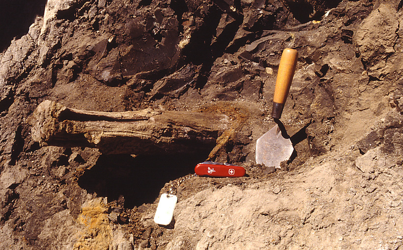
|
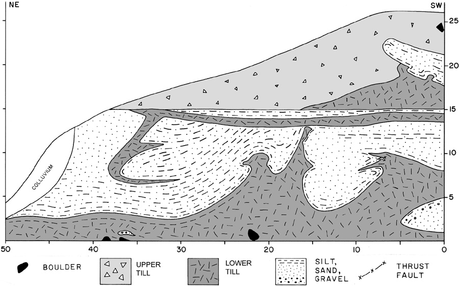 Measured section in the Independence Formation stratotype, West Atchison, Kansas. The lower gray till and middle sand are strongly deformed and overlain by the upper brown till. Taken from Aber and Ber (2007).
| |
The middle unit consists mainly of sand, silt, and gravel that were deposited in a large proglacial lake, namely Lake Atchison. These deposits are found mainly in the preglacial valley that was dammed by the early Independence ice advance. The lake must have risen rapidly, as it received meltwater drainage from the ice sheet as well as run-off diverted from all the northern Great Plains and Rocky Mountains. The lake eventually overflowed its drainage divide north of Manhattan, north of Kansas City, and several places in between; spillway valleys were quickly eroded through soft shale and limestone bedrock. The resulting catastrophic floods cut the present lower Big Blue, Kansas, and Missouri River valleys. Once established, these routes continued as the principal drainage system for northeastern Kansas.
The upper brown till at the stratotype is associated with directional indicators formed by north-northwesterly ice movement. The late Independence Glaciation reached its farthest extent west of the Big Blue River and south of the Kansas River valleys. Its maximum limit was controlled by the positions of resistant bedrock escarpments. Between these bedrock obstacles, small ice tongues spread southward over intervening lower areas. The farthest south position was reached east of Lawrence in the Hesper Plain by the Clearfield ice tongue at 38.85° N latitude (Merriam 2003).
Weight of the ice sheet caused the crust to depress, and this was compensated by uplift of a forebulge to the west and south of the ice mass. The result was a drainage moat between the ice margin and higher ground beyond, in which a series of large proglacial lakes was dammed in the vicinity of Manhattan, Wamego, Topeka, and elsewhere along the glacial margin. Few traces of the actual lakes remain today, although glaciolacustrine sediment is preserved at many sites.
Catastrophic flooding from these lakes left a prominent record, however, including a bouldery esker in southern Topeka. Several smaller valleys, such as Mill Creek, Wakarusa River, and Turkey Creek valleys, that parallel the Kansas River valley were eroded as spillway routes during floods. Conspicuous boulder beds along the glacial border zone in Wabaunsee, Shawnee, and Douglas counties were deposited by these floods.
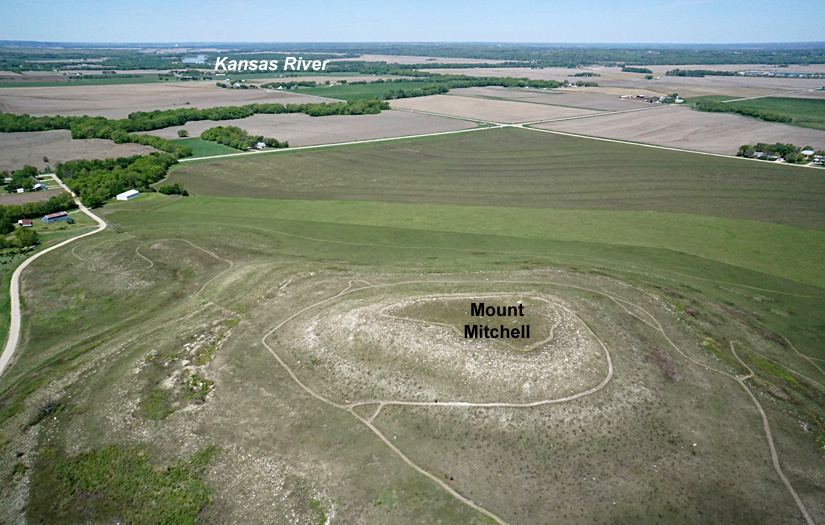
| Kite aerial overview of Mount Mitchell (left) at the southwestern limit of glaciation, south of Wamego, Kansas. During maximum glaciation, the Kansas River valley was blocked and proglacial Kaw Lake was impounded in this vicinity (Todd 1918b). Massive influx of icebergs and periodic floods of meltwater carried erratics across the lake and deposited them on Mount Mitchell. Boulder of Sioux Quartzite (right) is about 1 m long. | 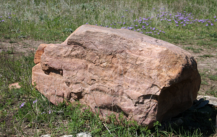
|
Return to beginning.
| Wall of volcanic ash exposed in the Cudahay Mine on the High Plains near Meade, Kansas. Height of wall about 20 feet. This is the original Pearlette ash bed, now correlated with the Lava Creek Tuff of Yellowstone and dated about 0.63 million years old. |
| Ash name | Age | Source |
|---|---|---|
| Pearlette | 0.63 | Lava Creek Tuff Yellowstone |
| Hartford | 0.75 | Mount Jackson Rhyolite Yellowstone |
| Mount Claire | 0.8 | Bishop Tuff, California |
| Coleridge | 1.2 | Mesa Falls Tuff Yellowstone |
| Borchers | 2.0 | Huckleberry Ridge Tuff Yellowstone |
| Ages in millions of years. Based on Boellstorff (1976), Naeser and Naeser (1988), and Matthews et al. (2015). |
| Wathena gravel pit, Doniphan County, Kansas. Vertical section (left). Preglacial alluvium containing the Wathena Local Fauna is exposed at the bottom below the lower gray till of the Independence Formation. Scale pole marked in feet. Close-up view of basal gravel (right). Note erratic quartzite pebbles derived from High Plains and Rocky Mountain sources and typical of preglacial gravels in eastern Kansas. | 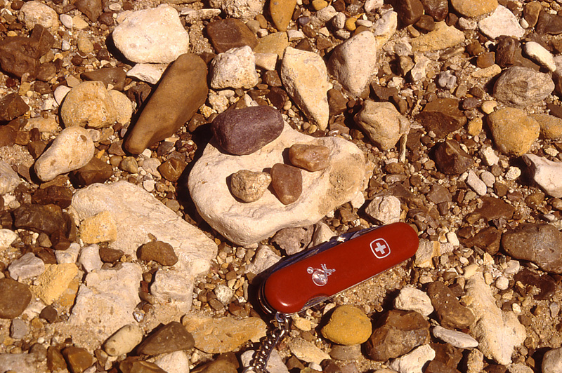 |
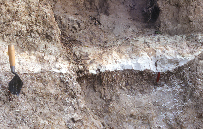
| Volcanic ash within post-glacial alluvium of the Kansas River valley near De Soto. Correlated with the Pearlette volcanic ash, which is dated about 0.63 million years old. This ash provides a minimum age for glaciation in Kansas. |
The possible age range is further narrowed by till paleomagnetism. Lower Independence till displays two paleomagnetic patterns in both surface and subsurface samples: a) normal polarity where no structural disturbance is present, and b) mixed polarity in structurally disturbed settings such as the diapir at the stratotype. Till in the Kansas City, Missouri vicinity likewise displays normal magnetic polarity (Colgan 1998). Older tills with reversed paleomagnetism are present, however, to the north in Nebraska and Iowa, and Roy et al. (2004) revealed the presence of tills with reversed polarity in northeastern Kansas.
Based on these several dating methods, the age range for the Independence Glaciation is bracketed between approximately 810,000 to 640,000 years ago, including marine-isotope stages (MIS) 20-16 from the latest Matuyama to early Brunhes paleomagnetic chrons (Aber 2022). This timespan corresponds with the Don Glaciation of the Eastern European Plain about 650,00 years ago (Lisiecki and Raymo 2005). Globally this was appropriately one of the largest episodes of ice-sheet glaciation during the Pleistocene Epoch (Lang and Wolff 2011). The Independence Formation, thus, represents one of the oldest and greatest Pleistocene glaciations with a well-preserved record on land (Aber 1991).
Return to beginning.
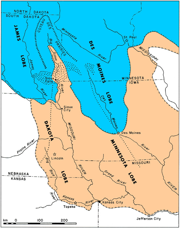 Northern Great Plains showing Independence (tan) and Wisconsin (blue) glacial features. Dotted zones show Sioux Quartzite bedrock; dotted lines are limits of the Sioux Quartzite erratic fan to the south. Adapted from Aber and Ber (2007).
| |
The older Independence ice sheet was thicker and completely covered the Coteau des Prairies. The northern part of the Coteau was probably not as prominent as today, but the Sioux Quartzite ridge was still a sufficient obstacle to split ice flow into a pair of ice lobes—Minnesota and Dakota. The lobes were confluent southward into Nebraska and Iowa, but evidently separated farther south. The Minnesota lobe was apparently first to reach Kansas from the northeast. As it approached, it overran a spruce forest and then deposited the lower gray till, dammed Lake Atchison, and caused meltwater flooding that eroded the Blue, Kansas, Delaware, Missouri and other spillway valleys.
The Dakota lobe entered Kansas later from the north-northwest; it laid down the upper brown till and caused catastrophic flooding along the maximum glacial border zone. Kansas City is located at a reentrant in the maximum ice margin, which might mark an interlobate boundary between the Dakota and Minnesota lobes. The genesis of the Missouri River valley in eastern Nebraska is problematic, however. It is clearly the result of glacial diversions, as it cuts across preglacial drainages; different portions may have formed in lobe-axis, interlobate, and/or lobe-marginal settings during different phases of ice-lobe advances and retreats (Aber 1991).
Return to beginning.
Combined references.

Return to Landscapes table of contents.
All text and images © by the authors (2022).