| of Canada
History of Geology |

Founded 1842, Montreal; moved to Ottawa in 1881.
| Abstract | Introduction |
| Origin of GSC | Expansion of GSC |
| GSC in 20th century | Related websites |
|
| of Canada
History of Geology |
Founded 1842, Montreal; moved to Ottawa in 1881.
| Abstract | Introduction |
| Origin of GSC | Expansion of GSC |
| GSC in 20th century | Related websites |
The geographic size of Canada increased greatly with Canadian confederation in 1867, addition of territories in the 1870s, and acquisition of Arctic Islands in 1880. Under its second director, A.R.C. Selywn, the survey undertook many expeditions to investigate western and northern frontier lands. The survey became a permanent government agency in 1877 and was moved to Ottawa in 1881. The Neptune expedition to the Arctic, led by A.P. Low in 1903-04, represents the last of great survey explorations.
Survey activities then began to decline, due to poor leadership and other factors, reaching an extremely low level of bureaucratic status during the 1930-40s. After World War II, the survey reestablished its reputation and position as a leading scientific research organization. The survey played an important role in the national priority for development of mineral and energy resources with minimal environmental consequences. By the early 1990s, however, Canada had accumulated high debt, and the geological survey was forced to accept massive cuts in personnel and total budget. Some programs were eliminated and others reduced by half. The Geological Survey of Canada is now in a rebuilding mode, based on increased cost sharing with other governmental and industrial partners.
Following the War of 1812, the northern border of the United States was fixed from the Atlantic
westward to Lake of the Woods (northern Minnesota). Several British colonies included Nova
Scotia and New Brunswick, along with Upper (Ontario) and Lower (Quebec) Canada. The latter
were united in 1840 as the Province of Canada.
Summer field surveys began in 1843 and have continued ever since. Logan explored the
Gaspé area, and Murray worked in the Great Lakes region. Logan erected three broad
subdivisions of bedrock.
This activity culminated with Geology of Canada. The text was published in 1863,
followed by a magnificent map at scale 1 inch = 25 miles in 1869 (dated 1866). Four
small-scale maps accompanied the text, including the first map of surficial geology.
This essentially completed the original commission for the GSC, which had:
Finally in 1877, the GSC was assigned as a branch of the Interior Department and, thus,
given permanent status and guaranteed continued funding. Employees became civil servants
entitled to many benefits and pensions. The price to pay for this status was relocation
to Ottawa, the capital. The move was opposed by universities and mining companies in
Montreal, but was completed nonetheless in 1881.
As early as 1845, the GSC was directed to organize a museum. A steady growth of collections
took place, to which botanical and zoological surveys were added in 1879-89.
The combined collections became known as the "Geological and Natural History Survey of Canada," which includes the Haida
Indian collection of Dawson from the Queen Charlotte Islands. The museum is now housed
in a large limestone building (since 1910) in Ottawa.
The Neptune expedition to the Arctic, led by A.P. Low at the beginning of the 20th
century, marks the close of an era for the GSC. In six decades time, the GSC had experienced
remarkable growth. It played a dominant role in exploration, mapping, and scientific study
of frontier lands. GSC operations had revealed the great diversity of Canadian resources and
opened the tremendous geologic history from the oldest Archean crust to Quaternary glaciation.
Following World War II, the GSC was renewed to a leading position in scientific
research. A balance was established between basic and applied studies, and development
of mineral and energy resources became a national priority. During the 1970s and '80s,
concern grew over environmental issues, such as the consequences of acid rain. The GSC
also played a prominent role is providing scientific evaluation of Canada's offshore
economic zone. In 1986, the Earth Physics Branch of Energy, Mines, and Resources was
merged with the GSC, and in the following year
the Polar Continental Shelf Project (an Arctic logistics organization) was linked with
the GSC (Vodden 1992).
By the late 1980s, the GSC could rightfully claim to be one of the top geological surveys
in the world. It employed about 1000 scientists and support staff with an annual budget of
more than $C100 million. The GSC began to cooperate more closely with other federal,
provincial and territorial surveys, as well as universities and private companies. At the
time of its sesquicentennial celebration, the GSC was able to claim the following
(Vodden 1992, p. 55).
Applied minerals and energy research suffered the greatest cuts; marine geology was
severely trimmed also because of its high-cost field logistics. Some programs, such as
paleomagnetism and meteorite studies, were deemed better suited for academic research.
They were reduced or eliminated. Almost all senior scientists took advantage of early
retirement options. By 1998, the GSC staff had been reduced from more than 1000 to about
700, and the annual budget had been cut from $C110 million to around $C60 million, a
reduction of 45% (Franklin 1999).
The Geological Survey of Canada began rebuilding in the early 21st century. Cooperative partnerships have
been established with other federal agencies, provincial surveys, universities, and some
industries. Cost sharing and in-kind support are utilized to a much greater extent than
before, as well as funding from the private sector. Major challenges remain, nonetheless,
for example support of international and multidisciplinary initiatives in the geosciences. The GSC celebrated its 175th anniversary in 2017, which coincided with Canada's sesquicentennial of Confederation.
Return to history of geology syllabus or schedule.Introduction and creation of Canada
The Geological Survey of Canada celebrated its sesquicentennial in 1992, making it
the oldest scientific survey/service organization in Canada. It started with two men and
a budget of £1500 ($6000). It is now a leading scientific research and service
agency within the world's second largest country, which possesses great mineral and energy
wealth.
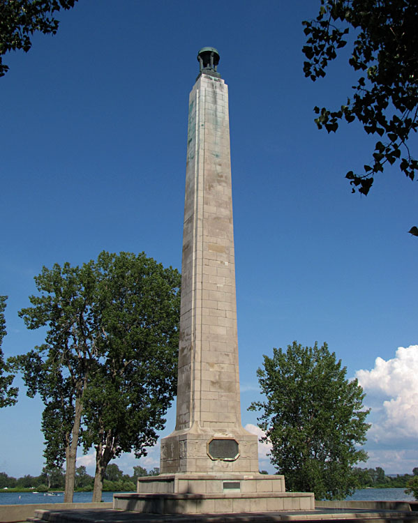
Monument to Commodore Oliver Hazard Perry on Presque Isle, Pennsylvania. Perry built a naval fleet at Erie, protected by Presque Isle, and defeated the British in the Battle of Lake Erie during the War of 1812.
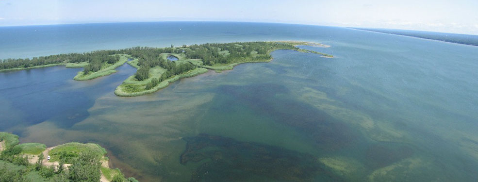
Panoramic view from Presque Isle looking toward Lake Erie in the background. The Pennsylvania mainland appears in the right distance. Kite airphoto © J.S. and S.W. Aber.  Historical maps of Canada.
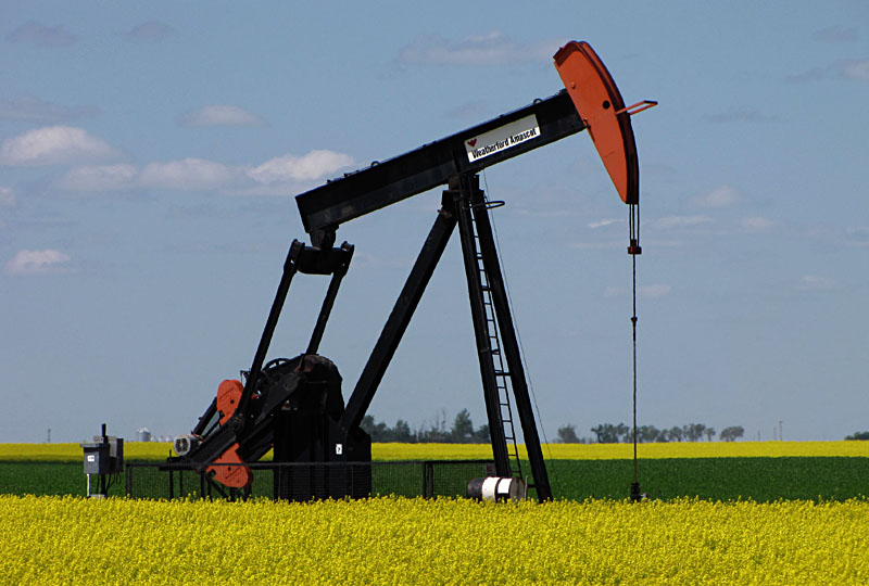
Saskatchewan is a resource-rich province. Left: oil well in the Williston Basin. Right: Aerial overview of Old Wives Lake. Sodium-sulfate is present both in the brine and in salt deposits, mainly as the mineral mirabilite (Glauber's salt). Photos © J.S. Aber.
Origin of the Geological Survey of Canada
The Geological Survey of Canada (GSC) was established by the Province of Canada in 1841 and
actually began in 1842, when William Edmond Logan was appointed as director. Logan was born
in Montreal and educated in Edinburgh, Scotland. His geological interest developed through
a family business in southern Wales. Alexander Murray became Logan's assistant, and headquarters
were established in Montreal. This was a time of industrial expansion based on coal and iron
in the United States, and there were great expectations for similar developments in Canada.
The GSC had an immediate economic and mining emphasis on coal, copper, and other industrial
raw materials.
A copper-rush in northern Michigan extended across the border into Canada in 1845-47. In
this connection, Logan established a delicate balance between governmental agencies and
private companies. The GSC
provided general geological information as a basis for industry. Beginning in the 1850s,
new staff was added in other fields, such as chemistry and paleontology. Logan organized
mineral collections for international exhibitionsŚLondon (1851) and Paris (1855). The
first maps and reports were prepared for these exhibitions.
The map and report represent the first comprehensive description and illustration of geology
in what is now southern Quebec and Ontario. Confederation in 1867 increased the geographic
area of Canada ten-fold, 25 years after the survey was founded. Logan retired in 1869, and
A.R.C. Selywn was appointed the second director.
 GSC important
early geologists.
GSC important
early geologists.Expansion of the Geological Survey of Canada
Under Selywn's leadership, tremendous expeditions were undertaken mainly in western and
central Canada. The GSC was in the vanguard of mapping and assessing the new lands of
Canada. For its first 35 years, the GSC lacked any guarantee of continuity; parliment
renewed its budget on a 5-year or sometimes annual basis. Logan and later Selywn had
to organize political support each time. Political crises, such as the U.S. Civil War,
disrupted the funding process.Geological Survey of Canada during the 20th century
The GSC has experienced dramatic variations in response to changing political and
economic fortunes. Following the Neptune expedition, the GSC underwent a
long-term decline. By the 1930-40s, it had sunk to an extremely low bureaucratic
level of influence and effectiveness within the government. This was due to a
combination of poor leadership, shift away from basic research to applied (mining)
emphasis, government reorganizations, the Great Depression, and World Wars.
However, budget disaster struck soon after the sesquicentennial. Canada encompasses the
second largest land area of any country, but has only one-tenth the population of the
United StatesŚmost living near the U.S. border. At the beginning of the 1990s, the country had accumulated an unsustainable
level of debt. In 1994 the Minister of Finance announced target budget
reductions for governmental agencies, which were asked to respond with a schedule of
program reductions or eliminations (Franklin 1999). GSC was forced to evaluate all its
activities. In general, basic research fared well, while applied activities and expensive
field operations were rated low.  Related websites from Natural Resources Canada
References

© J.S. Aber (2017).
 Table of Contents