| landscapes James S. Aber |
| Introduction | Vatnaj—kull |
| M»rdalsj—kull | SlÕttj—kull |
| K—tluj—kull | References |
|
| landscapes James S. Aber |
| Introduction | Vatnaj—kull |
| M»rdalsj—kull | SlÕttj—kull |
| K—tluj—kull | References |
| Ice Cap | Area (1958) | Area (1980) |
|---|---|---|
| Vatnaj—kull | 8538 | 8300 |
| Langj—kull | 1022 | 953 |
| Hofsj—kull | 966 | 925 |
| M»rdalsj—kull | 701 | 596 |
| Drangaj—kull | 200 | - |
| Eyjafjallaj—kull | 107 | 78 |
| Tungnafellsj—kull | 50 | 48 |
| Thorisj—kull | 33 | 32 |
| Thrandarj—kull | 27 | 22 |
| Tindfjallaj—kull | 27 | 19 |
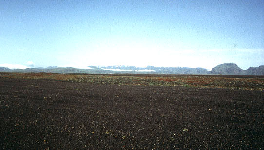
Iceland is, thus, a natural laboratory in which to observe the interaction of glaciers, climate, volcanoes, and the resulting sediments and landforms. The modern elements of glacial dynamics and glacial geomorphology in Iceland provide excellent models for conditions that existed for larger Pleistocene ice sheets in Europe and North America.

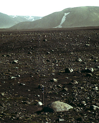
| Tephra (volcanic ash) bed melting out from northern margin of M»rdalsj—kull ice cap, southern Iceland. Such volcanic deposits are very common within glaciers of Iceland. Photos © by J.S. Aber. |
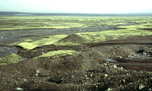
| M»rdalssandur outwash plain, southern Iceland. Sandur plains are formed by massive flows of sediment-rich glacial melt water. This plain was innudated in 1918 by a j—kulhlaup flood during the eruption of Katla volcano beneath M»rdalsj—kull ice cap (visible in distance). |
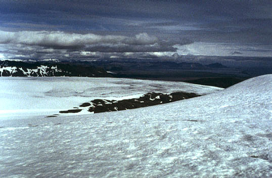
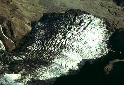
| Overview from southeastern edge of Vatnaj—kull ice cap, Iceland. The accumulation zone is visible in the foreground, a large outlet glacier can be seen in the middle distance, and the Atlantic Ocean appears on the far horizon. Elevation of foreground is about 1100 m a.s.l. Photos by J.S. Aber. |
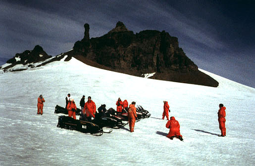
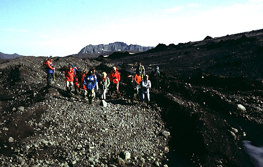
| A snowmobile tour resting on the southeastern edge of Vatnaj—kull ice cap, Iceland. Access to the glacier is routine during the summer months, and many tourists now visit Europe's largest ice cap. |
Vatnaj—kull possesses all manner of large and small outlet glaciers. Brµkarj—kull is a dramatic glacier on the southeastern margin of the ice cap. This glacier begins as an icefall from the edge of Vatnaj—kull and is reconstituted as a small valley glacier at the bottom of the ice fall. The vertical relief from head of the ice fall to the glacier's snout is nearly 1 km. Hoffellsj—kull is typical of mid-sized valley glaciers on the eastern side. It moves up to 630 m per year and is about 250 m thick (BÃrdarson 1991). Several outlet glaciers have surged during modern times; for example, SÚduj—kull underwent a massive surge during the spring of 1994. Most outlet glaciers terminate on land, but Breidamerkurj—kull ends in a lake just short of the sea.

| Overview of Brµkarj—kull, a spectacular small outlet glacier on the southeastern side of Vatnaj—kull, Iceland. The glacier begins at an ice fall on the left and descends into the valley on the right. The vertical drop of this glacier is about 1 km. |
| Telephoto view of the snout of Brµkarj—kull, as seen from above. Notice the beautiful display of crevasses near the ice margin. Photos © J.S. Aber. |
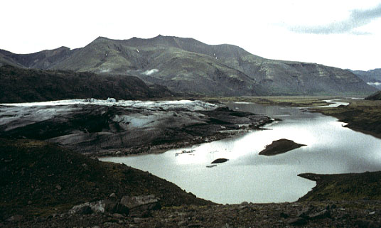
| Lower portion of Hoffellsj—kull, a typical large outlet glacier on the eastern side of Vatnaj—kull. This glacier ends partly on land and partly in an ice-marginal lake. |
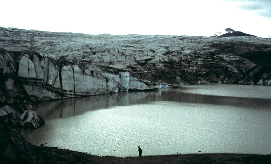
| Hoffellsj—kull ice margin and proglacial lake. Much glacially derived sediment accumulates in such lakes. |
On Sept. 30, 1996, a major volcanic eruption began at Bardarbunga volcanic center under Vatnaj—kull. Melt water generated by the eruption drained into GrÚmsv—tn and collected throughout the month of October. As much as 3 km³ of melt water was trapped. A j—kulhlaup began on Nov. 5; it quickly increased in magnitude reaching a peak discharge of 45,000 m³/s about 15 hours after starting. This was one of the largest j—kulhlaups of this century in Iceland. Bridges, roads, electric lines and communication cables were washed away. Total damage is estimated at $10-15 million.
The Skaftafell region, south of Vatnaj—kull, contains a long stratigraphic record of volcanic eruptions and glacial deposits. Subaerial eruptions produced lava flows, whereas subglacial eruptions resulted in pillow lavas and breccias. The composite sequence exposed in cliffs records nearly five million years of strata, which have been dated by magnetic-reversal and potassium-argon techniques. This sequence demonstrates at least 16 glacial-interglacial intervals (Helgason and Duncan 2001). The earliest glaciations were limited in duration; after 2.6 million years ago the frequency and intensity of glaciations increased significantly, and a further increase took place since about 800,000 years ago. These major stages in glaciation intensity correspond to similar conditions throughout the North Atlantic and worldwide.
M»rdalsj—kull
M»rdalsj—kull is located on the active volcano Katla, which is part
of the Eldgjà volcanic trend in southern Iceland. The ice cap has two
summits >1400 m high and continues in an unbroken cover down to 1000-1300 m
elevation, below which the ice splits into several outlet glaciers of
various types. The southern and central portions of
the ice cap are located within the Katla caldera, where ice thickness
reaches 600-800 m. The northern part of the ice cap is situated outside
the caldera and is a largely independent glacial system.
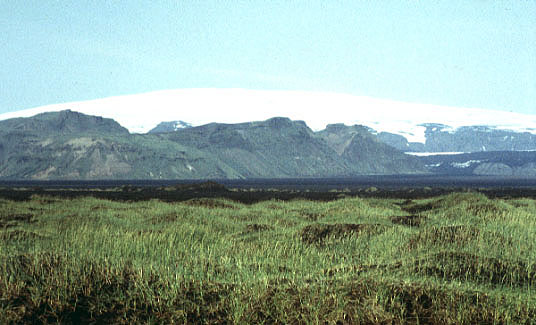
| Haabunga dome of M»rdalsj—kull on horizon and a portion of M»rdalssandur in foreground. The ice-cap dome reaches an altitude of nearly 1500 m, and the sandur is <100 m a.s.l. The ice dome buries Katla, an active volcano that last erupted in 1918. Photo © by J.S. Aber. |
SlÕttj—kull
The glacial foreland of SlÕttj—kull provides an excellent scale model for glacial landscapes of Pleistocene ice sheets. The 20-km-long ice front slopes gently down to a low-relief plain, on which fresh glacial
deposits and landforms are well preserved. The glacier ice is remarkably clean, and most sediment is transported in the
lowermost few cm of the glacier. Near its margin, the glacier moves about
20 m per year by a combination of basal sliding and subglacial shearing
(Kr■ger 1994).
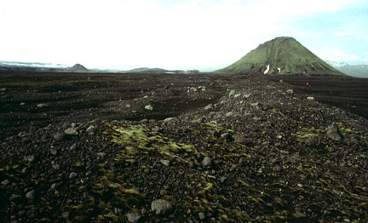
Marginal zone of SlÕttj—kull, northern edge of
M»rdalsj—kull, Iceland. A terminal moraine is visible in the
foreground and SlÕttj—kull can be seen on the left horizon;
MÌlifell is the small volcanic cone to right.
Photo © by J.S. Aber.
Large dirt cone next to crevasse on margin of SlÕttj—kull.
The dirt cone consists mainly of clean glacier ice with a cover of reworked
volcanic ash (tephra) only a few cm thick. The dirt cone stands about 3 m
(10 feet) high. Photos © by J.S. Aber.
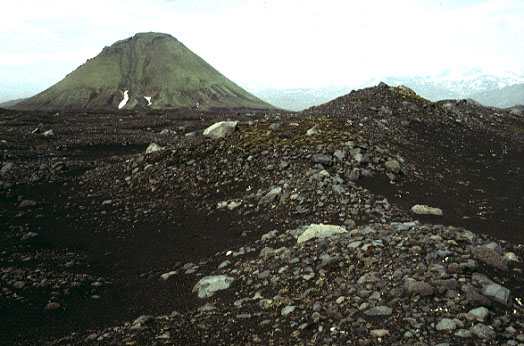
Terminal moraine of SlÕttj—kull; MÌlifell volcanic cone in
background. This moraine was constructed at the glacier margin in the
latest 1800s and early 1900s. It consists of bouldery, poorly sorted
sediment deposited at the ice margin. During this century,
SlÕttj—kull has retreated to its present position about 2 km away
(left of this view). Photos © by J.S. Aber.
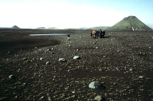
The field party is standing on the overridden push moraine in front of
SlÕttj—kull; MÌlifell volcanic cone in background. This
moraine is located about halfway between the terminal end moraine and the
modern margin of SlÕttj—kull. The push moraine was constructed
during glacier advance around 1800. Notice shallow source depressions to left.
The moraine was overrun during a subsequent readvance in the late 1800s, when
the glacier smoothed the moraine and left flutesparallel stone stripes
running left to right.
Fluted ground moraine in front of SlÕttj—kull, Iceland. Flutes
consist of slightly higher, more stony stripes a few m in width. Here, a
flute begins at the boulder and continues several 100 m into the distance,
and many parallel flutes can be seen. Ice axe for scale.
Ice margin of SlÕttj—kull, Iceland. Field party is standing on
the small marginal moraine that built up in front of SlÕttj—kull
during the 1980s. The low-sloping, dirt-covered ice margin is visible to
the right. Photo © by J.S. Aber. K—tluj—kull
The K—tluj—kull ice tongue transports a huge mass of sediment debris of subglacial and englacial origin. The outer 1-3 km
of the glacier is almost completely covered by sediment. Volcanic ash is derived from a thick bed that crops out at the upper limit of
dirt-covered ice. This ash was deposited during Katla's last
major eruption in 1918, during which up to 8 m of pumice accumulated on
M»rdalssandur south of K—tluj—kull.
The 1918 tephra became buried within the accumulation zone and since has gradually migrated into the the ablation zones of several outlet glaciers. The 1918 tephra serves as a marker bed to track movements of K—tluj—kull (Kr■ger 1994). The limit of dirt-covered ice has migrated downglacier with decreasing velocity as it has approached the ice margin: 225 m/yr (1918-45), 100 m/yr (1945-60), 80 m/yr (1960-80).

| Northern margin of K—tluj—kull, a large outlet glacier on the southeastern side of M»rdalsj—kull, Iceland. Note dark color of ice margin zone caused by heavy cover of reworked tephra and glacial sediment. The upper border of the dark zone marks the position of the 1918 tephra bed within the glacier. Photo © by J.S. Aber. |
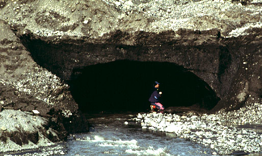
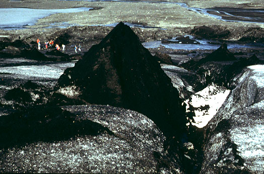
| Active melt-water tunnel at base of K—tluj—kull. The tunnel completely fills with water during periods of rapid melting and/or rainfall on the glacier. Note complete sediment (mud) cover on adjacent glacier ice. Jens-Ove Nðslund (Sweden) poses for scale at mouth of tunnel. Photos © by J.S. Aber. |
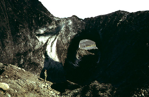
| Remnant of large ice tunnel on upper margin of K—tluj—kull. This tunnel is >10 m in diameter; note person standing to lower left, Seppo Hassinen (Finland). When active, this tunnel could have carried at least 200 m³/sec melt-water discharge. |

| Remnant of small ice tunnel preserved beneath dirt cones on surface of K—tluj—kull. This tunnel is about 1 m in diameter; note person sitting behind tunnel. The great number of large and small ice tunnels bears witness to tremendous melt-water discharge from K—tluj—kull. |
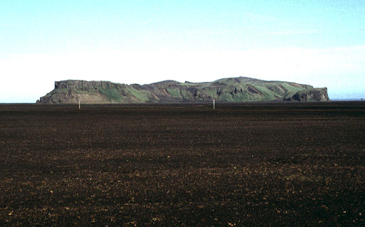
| The rock cliffs of Hj—rleifsh—fði rise > 200 m above M»rdalssandur outwash plain, southern Iceland. In Viking times, Hj—rleifsh—fði was an offshore island. It is now part of the mainland as a result of sediment accumulation and expansion of M»rdalssandur. During Katla's eruption of 1918 the coastline was built out as much as 4 km. |
| Small push moraines in front of K—tluj—kull date from minor ice advances of the 1950s (moss covered) and 1980s (bare). K—tluj—kull has since retreated about 100 m (or less, to right). M»rdalssandur outwash plain and the Atlantic Ocean are visible in the background. Photo © by J.S. Aber. |

 Glossary or references.
| Return to Glacial geomorphology (2020).
All images and text ˋ J.S. Aber. |
 Table of Contents