
| and Weston, Missouri |
| Introduction | Historical maps |
| Kite aerial photos | Landsat images |
|
| and Weston, Missouri |
| Introduction | Historical maps |
| Kite aerial photos | Landsat images |
On July 2nd, the Corps of Discovery camped opposite an old Kansa village, just above Kickapoo Island, north of present-day Fort Leavenworth. Lewis and Clark had heard of Fort de Cavagnial and decided to take a look. About a mile inland from the old Indian village, they found signs of the fort, including remains of chimneys and a spring which supplied fresh water to the fort (Hoffhaus 1984). Alas, the whereabouts of Fort de Cavagnial were subsequently lost, and the fort's remains cannot be located today, in spite of much searching.
A short distance upriver and across the valley from Fort Leavenworth is Weston, Missouri. Weston was founded in 1837 and became a thriving riverport town with a population of 5000 by the mid-19th century (Fanselow 1994). A flood caused the Missouri River to relocate in the late 1800s, which led to a serious economic decline. Lewis and Clark sampled the water from limestone springs at Weston, and the springs later became an important stop for wagon trains. The spring water was perfect for making whisky, and in 1856 Benjamin J. Holladay openned a distillery, which is still in business as the McCormick Distilling Company.
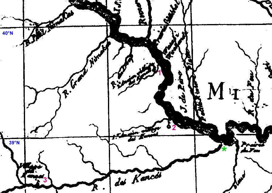
| Portion of Carte du Missouri by F.P. du Lac (1802). This French map predates the Louis and Clark journey by just a few years. It depicts a broad river channel with numerous sand bars. 1 = earlier village of Kansa Indians, near modern Doniphan, KS; 2 = younger village of Kansa Indians near present Fort Leavenworth, KS; 3 = another village of Kansa Indians on the Kansas River near Topeka, KS. Green star indicates Kawsmouth, the future site of Kansas City, Missouri. The 40°N latitude is the present border between Kansas and Nebraska. Click on small image for a full-sized version (157 kb). |
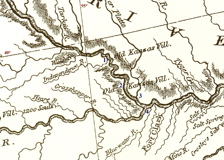
| Portion of Clark's map showing the lower Missouri River. Key: 1 = old Kansa Indian village of the early 1700s. 2 = old Kansa Indian village during the time of Fort de Cavagnial. 3 = mouth of the Platte River, below present Leavenworth, Kansas. 4 = Kawsmouth in modern Kansas City. Notice the lack of any large meanders in the Missouri River between sites 2, 3 and 4. Taken from a reproduction of Clark's original map; Oregon Historical Society Press © (1998). Click on small image for a full-sized version (209 kb). |
The most prominent feature of the Missouri River today in this vicinity is the large meander loop, known as Weston Bend, that crosses the valley at Fort Leavenworth. Clark's map does not show such a feature, nor do contemporary French maps--compare maps above and below. Given their focus on river travel, the Corps of Discovery could not have missed such a large meander. Clark's map clearly shows the Missouri River along the western bluffs of the valley between Fort Leavenworth and Kansas City.
When Fort Leavenworth was founded in 1827, it was sited where the Missouri River flowed along the western valley side, from whence keelboats and later steam-powered riverboats could unload supplies onto a slope leading to high ground. A large meander loop did exist at that time; however, the historic riverboat landing at Fort Leavenworth is now dry land as the meander has migrated downstream. This evidence suggests the Weston Bend meander did not exist in the earliest 1800s. It seems more likely that the river channel of Lewis and Clark followed the western side of the valley.
 |
| Portion of Map of the Missouri River compiled by the U.S. Army Corps of Engineers (1878-81, plate XV). Notice the main river channel passes north of Kickapoo Island at Weston, MO and around a large meander loop at Fort Leavenworth, KS. Click on small image to see an enlarged version (45 kb). |
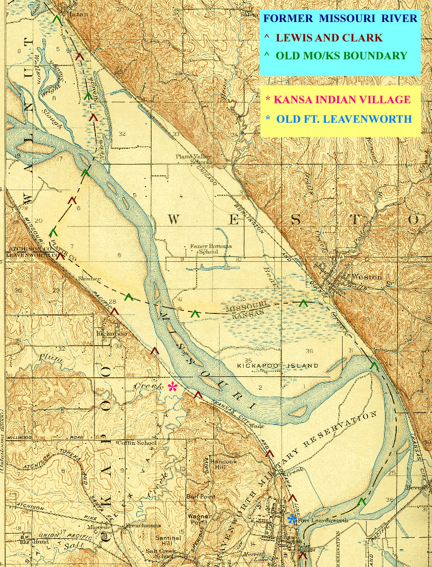
| Portion of Leavenworth, 15-minute, topographic quadrangle dating from 1910. The old Missouri River of Lewis and Clark probably followed the western margin of the valley; whereas, the old MO/KS border looped across the valley north of Kickapoo Island. Both Iatan and Weston, Missouri were founded at points where the river flowed against the valley bluffs in the early 1800s, but the river later shifted away from these towns. Locations are indicated for the old Kansa Indian village and the original riverboat landing for Fort Leavenworth. The river has subsequently migrated downstream from the original riverboat landing at Fort Leavenworth. Note the character of the Missouri River--wide channel with many sand bars; compare with the modern digital airphoto below. Click on small image for a full-sized version (620 kb). |
Digital orthophotograph quadrangles (DOQs) are scanned and georectified "base maps" derived from modern airphotos. A DOQ is presented below for the southern portion of the Weston, MO/KS map quadrangle, which includes the northern portion of Fort Leavenworth, KS and Weston, MO.
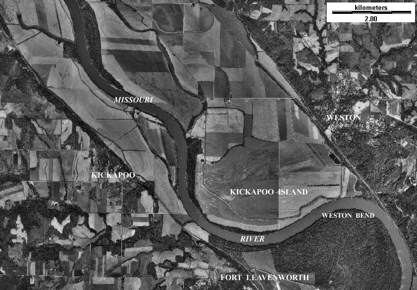
| Digital orthophotograph of southern portion of the Weston, MO/KS quadrangle. The Missouri River today forms a wide meander loop, Weston Bend, around the bottomland of Fort Leavenworth. Compare this modern view of the Missouri River with historical maps (above). Click on small image for a full-sized version (197 kb). |
The modern Missouri River is quite different in character compared to its pre-control ancestor navigated by Lewis and Clark. The historical maps indicate a river channel that was broad, shallow, and clogged with many ephemeral sand bars. In addition, the uncontrolled river had many diverging side channels, sloughs, and marshy tributaries. The old Missouri River was subject to annual floods from spring runoff in the Great Plains and snow melt in the Rocky Mountains. The DOQ shows a river of completely different character today. Weston, Missouri is now landlocked, and Kickapoo Island is joined to the bottomland on the Missouri side of the river.
The modern Missouri River has been "tamed" by the U.S. Army Corps of Engineers with upstream reservoirs, levees, dredging, and other techniques. Barge traffic and flood control are primary objectives of river management. The net result is a narrower, deeper, single channel that has been straightened or shortened in many places. The Corps strategy seemed to work well until the summer of 1993, when continuous rain and runoff overwhelmed all flood-control structures on the lower Missouri. The valley was completely innundated at Fort Leavenworth. This event has caused the Corps to rethink its approach for future river management.
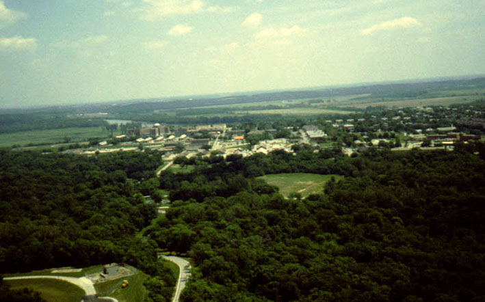
| Overview toward east from forested ridge on west side of Ft. Leavenworth. The main fort complex is visible in middle distance with the Missouri River and bottomland in the background. Photo date 5/98; © J.S. Aber. |
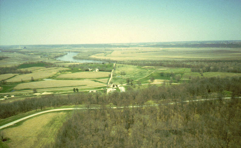
| Early spring view toward north from Hancock Hill, Ft. Leavenworth. The French Fort de Cavagnial was located somewhere in the left middle distance of this view, and the Missouri River and valley bottomland are visible in distance. Forest trees are leafless at this time of year. Photo date 4/98; © J.S. Aber. |

| View northward along bedrock ridge on west side of Ft. Leavenworth. The mixed deciduous forest consists of various oaks, walnut, hickory, and other hardwood trees. This mature forest has grown up since the time of Lewis and Clark. Some cloud shadows can be seen in this late spring view, and the Missouri River is visible in the upper left corner. Photo date 5/98; © J.S. Aber. |

| Missouri valley bottomland in vicinity of Sherman Army Airfield, Ft. Leavenworth. The road, which follows a levee, is named "Chief Joseph Loop" after the Nez Percé Indian chief. The forest in the background consists mainly of young cottonwood, willow, pecan, and other softwood trees. This bottomland was completely innundated during the Missouri-Mississippi flooding of July, 1993. Photo date 5/98; © J.S. Aber. |
All text and images © J.S. Aber.
Last update: Mar. 2005.