| James S. Aber |
| Morphologic sequences | Glaciolacustrine sediments |
| Glaciomarine sediments | Stratified sediment landforms |
| Related sites | References |
|
| James S. Aber |
| Morphologic sequences | Glaciolacustrine sediments |
| Glaciomarine sediments | Stratified sediment landforms |
| Related sites | References |
A morphologic sequence is a progression of meltwater deposits and landforms graded to a discrete ice-margin position. Many possible morphologic sequences may be developed. A given sequence exhibits systematic downstream changes in sediment texture, composition, thickness, and morphologic expression. As the ice margin periodically retreats, a series of morphologic sequences may build up in an overlapping arrangement.

| Poorly sorted, unstratified sediment from ice-contact position of morphologic sequence, Chenango valley, south-central New York. Note angular clasts and broken shale mass (right of trowel) within this sediment, which exhibits minimal influence of meltwater transportation. |

| Stratified drift deposited by glacial meltwater stream, Chemung valley, south-central New York. Note variable texture and sorting of interbedded silt, sand, pebbly sand, and gravel. Cliff-swallow nests are located in silty sand beds. Scale pole marked in feet. |
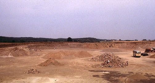
| Overview of gravel pit in outwash (sandur) plain, eastern Germany. The Pomeranian end moraine (ice margin) can be seen in the left background. Sediment of the sandur plain was deposited from braided river channels. |

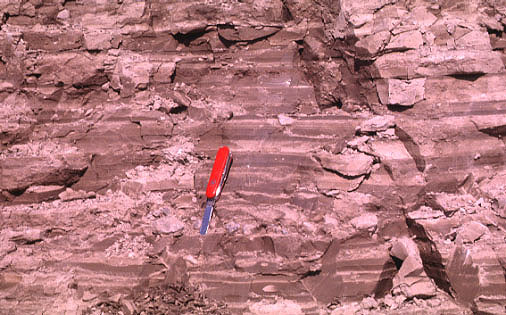
| Closeup view of stratified sand and gravel beneath surface of Pomeranian sandur plain. Note horizontal bedding and relatively good sorting of individual layers. Section is about 10 feet (3 m) high. |
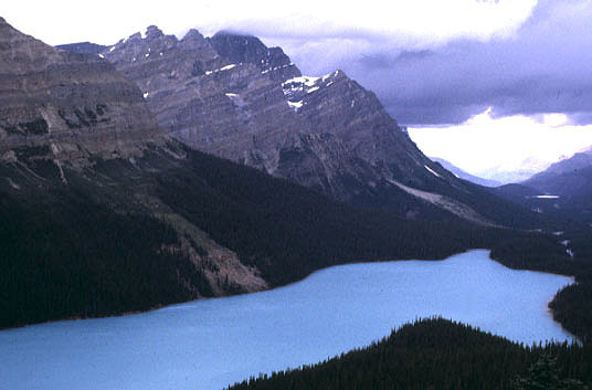
| Peyto Lake, Canadian Rockies, Alberta. The milky, blue-green color of the lake results from a high content of suspended sediment (rock flour) washed in from nearby Bow Glacier. Such lakes have very high rates of sediment accumulation. |
| Glaciolacustrine sediment exposed in bluffs along west side of Lake Michigan, Wisconsin. Note rhythmic layering; individual thick-thin couplets are varves. Each varve represents one year of sediment accumulation--thick layer during summer and thin layer during winter. Also note small pod of pebbles toward left side. Such coarse sediment may have been dropped by a melting iceberg or could have been deposited by a turbidity current. |
Overflow from Lake Agassiz and other large proglacial lakes cut spectacular spillway channels across the northern Great Plains. Similar spillways were formed in the Great Lakes region. Much of the modern Mississippi, Ohio and Missouri drainage systems, as well as the Hudson and St. Lawrence systems, were created by such meltwater floods during the last deglaciation. The existence of large proglacial lakes strongly influenced subglacial drainage and could have fed water into subglacial lakes. Subglacial lakes in the Hudson Bay region may have facilitated glacier surges.
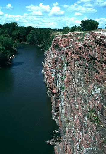
| Glacial meltwater spillway channel, Dell Rapids, South Dakota. This deep channel was cut through Sioux Quartzite (pink rock). Erosion of such highly resistant and massive bedrock demonstrates the power of meltwater flooding. |
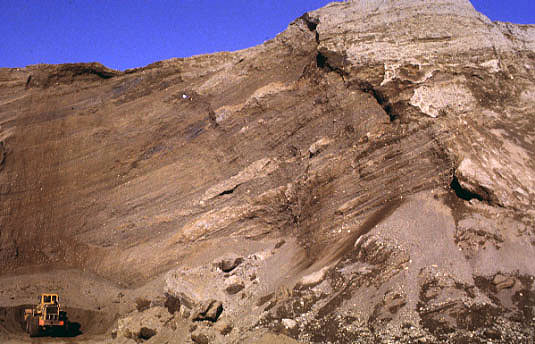
| Exposure within glaciomarine delta at Hegra, central Norway. Note the long, inclined foreset beds of sand and gravel that were deposited on the outer slope of the delta. Exposure is approximately 30 m high. |
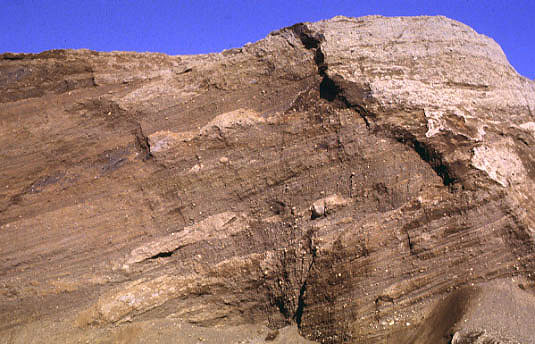
| Closeup view of foreset bedding within delta at Hegra. Note irregular pods or lenses of flow till interbedded with sand and gravel layers. The till was derived from a nearby glacier margin and moved down the delta slope as debris flows. |
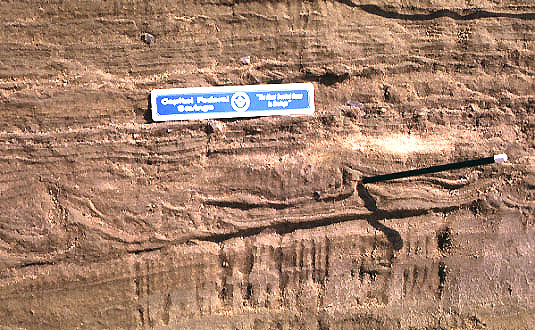
| Laminated silt and fine sand in a glaciomarine delta. Small folds could be the result of sediment compaction and slumping or a small ice advance. Pencil shows axis of one small folds. Herdla Island, western Norway. |
Lřnne (1995) elaborated three models for sedimentary facies and depositional architecture of glacial meltwater fan/delta accumulations in deep fjord or continental shelf environments. These models include: subglacial till, topset stream deposits, foreset delta beds, suspension fallout from meltwater plume, ice-rafted debris, and glaciotectonic deformation. The models differ according to position of the ice margin in relation to sea level and delta/fan surface.
Eskers are generally found behind and leading toward major end moraines,
deltas or outwash fans. Eskers may also be associated with valleys carved
by subglacial meltwater erosion; such channels are called tunnel
valleys. Extensive esker and tunnel-valley
systems reflect the subglacial meltwater drainage network developed during
late stages of glaciation and ice retreat.
Landforms of stratified sediments
Stratified sediment takes many interesting and distinctive landforms, such
as eskers and kames. Kames are hills or terraces that vary from
small conical peaks to broad, plateaus that are composed mainly of sand and gravel.
Kames are deposited in contact with stagnant ice from streams or as deltas and fans
in ice-marginal lakes or seas. When the stagnant ice later melts away, part
of the kame may collapse. A deep hole, called a kettle hole, may be
left where a buried mass of dead ice melts away. Kames and kettle holes
may be associated in a landform type called kame-and-kettle moraine.
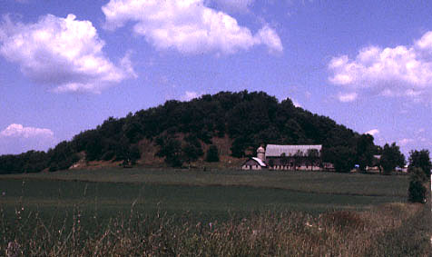
McMullen Hill, east-central Wisconsin. This conical hill is a classic
moulin kame composed of stratified sand and gravel. It was presumably
deposited at the bottom of a moulin (vertical meltwater shaft) within
stagnant ice. When the ice later melted away, a symmetrical hill was left.

Kame terrace, Eidslandet, western Norway. The terrace surface (farmsted)
is underlain by stratified sand and gravel of a glaciomarine delta. The
terrace scarp (foreground) represents the ice margin position and the terrace
surface marks sea level in the fjord at the time the delta was deposited.
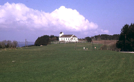
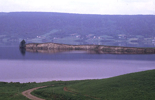
Overview of Herdla Island, western Norway. This island is the type
locality of the Herdla Moraine. The island represents a glaciomarine delta built
on shallow bedrock knobs at the entrance to fjords of the Bergen vicinity. The
church is located on a terrace surface that marks sea level (+32 m) at the time
of delta deposition.
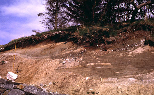
Exposure of glaciomarine sediment on side of Herdla Island. Sediment
is mainly silt and silty sand with small gravel bodies. The sediment was strongly
compacted and locally deformed by overriding ice.
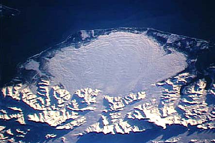
Malaspina Glacier, Alaska. NASA space-shuttle photograph, STS066-117-014, 11/14/94,
70 mm format. Low-oblique view toward south (top). Malaspina is a classic large piedmont
glacier that descends to tidewater from several mountain sources. This glacier has a
history of surging--rapid advances separated by periods of stagnation. The glacier is
mostly snow covered in this November view. NASA Johnson Space Center, Imagery Services.
Lövviksnäset esker, a classic esker ridge composed of stratified sand
and gravel. The esker is partly submerged in a lake, near Hoting, central
Sweden.

Near-modern esker ridge in front of Sléttjökull, northern margin
of Mýrdalsjökull ice cap, southern Iceland. This cobbly esker was
deposited from a meltwater stream in a subglacial tunnel. The esker has
since been uncovered as the ice margin retreated during this century.

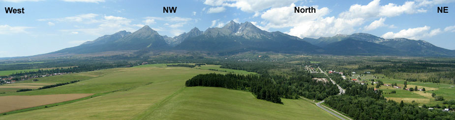
Panoramic view of the Tatra Mountains in Slovakia. Expansive surface in foreground is composed of glaciofluvial fans washed out of the mountains during Pleistocene uplift and glaciations. Kite aerial photograph © J.S. & S.W. Aber. More kite aerial photos of the Tatra Mountains.  Related sites

 Glossary or references.
Return to Glacial geomorphology (2020).
All images and text © J.S. Aber.
 Table of Contents