Glaciotectonic landforms
Glaciotectonic landforms are the morphologic expressions of subsurface
structural deformations brought about by glaciation. Such landforms range
from conspicuous ice-shoved hills, to smoothed plains, to anomalous
depressions (Aber et al. 1989). These landforms may display their
original glaciotectonic morphology, where little modified by later events.
More commonly, however, subsequent glacial or nonglacial erosion or
deposition has altered the initial landform, in some cases obliterating any
morphologic expression of the ice-pushed structures. In all cases, some
knowledge of subsurface stratigraphy and structure is invaluable for
properly interpreting the landforms.
Glaciotectonic landforms may be divided in two general categories on the
basis of their morphostructural attributes.
- Ice-shoved hills: constructional hills,
ridges, or moraines that rise above the general landscape as a result of
structural uplift of deformed rock and/or sediment material. Includes
hill-hole pairs, composite ridges, push moraines, and cupola hills.
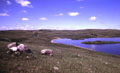
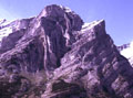
| View over crest of Prophets Mts., North Dakota. Prophets Mts. is a large
ice-shoved hill that rises nearly 100 m above the surroundings. The interior
consists of deformed upper Cretaceous and lower Tertiary bedrock along with
glacial sediments. |
- Glaciotectonic plains: subdued, streamlined, or smoothed plains.
Underlying structures include flat rafts or megablocks, intrusions and diapirs,
as well as buried ice-shoved hills and structural basins.
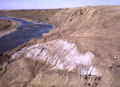
| Glacial megablocks of deformed Cretaceous sandstone exposed along bluff of
the Old Man River, near Tabor, southern Alberta. The source and distance
of transportation for these megablocks are unknown.
Note flat glacial plain on upland surface. |
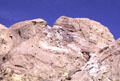
| Jumbled mass of crushed bedrock material in the core of a recumbent fold, near
top of section along bluff of the Old Man River, near Tabor, southern Alberta. Photos © J.S. Aber.
|
These forms represent ideal types within a continuous spectrum of
glaciotectonic phenomena. Intermediate, transitional or mixed forms exist
between these ideal types and are in fact rather common. The materials of
which these landforms are constructed may be classified in three groups:
(1) pre-Quaternary strata, that are usually consolidated to some degree,
(2) pre-existing Quaternary strata, both glacial and nonglacial, and (3)
penecontemporaneous glacial sediment, that was deposited and deformed
during the same glaciation. Most glaciotectonic landforms contain all
three types of material in varying proportions.
The hill-hole pair is the simplest and most
instructive type of ice-shoved landform. It consists of an ice-scooped
basin and related hill. Other kinds of ice-shoved
hills are variations of this fundamental form. These hills were often
misidentified as kames or bedrock outliers, depending on their internal
composition. Bluemle and Clayton (1984, p. 284) described the hill-hole
pair as, "a discrete hill of ice-thrust material, often slightly
crumpled, situated a short distance downglacier from a depression of
similar size and shape."
The depression is the source of material now in the hill, and ideally the
volume of the depression should nearly equal the hill's volume.
Depressions are now often the sites of bogs, lakes, or estuaries, and so
their apparent sizes are often reduced by later sedimentation. The
ice-shoved hills may also have been altered by later erosion or deposition,
so an exact volume correspondence does not always exist between the hill
and related hole. Hill-hole pairs are now widely recognized in many
different settings.
| Small hill-hole pair at Anamoose, North Dakota. Lake basin in foreground
is the source depression for material shoved into the hill in the background.
View in the downglacier direction. Anamoose is a classic locality for this
type of landform in North America (Bluemle and Clayton 1984).
|
The most typical and distinctive glaciotectonic landforms are ice-shoved
ridges found in many glaciated plains. Prest (1983, p. 45) aptly described
such ridges as, "a composite of great slices of up-thrust and commonly
contorted sedimentary bedrock that is generally interlayered with and
overlain by much glacial drift." Composite ridges typically display
multiple, narrow ridges separated by steep-sided valleys. The ridges are the upturned ends of thrust blocks or the crests
of folds. Maximum uplift of thrust blocks is may be >200 m, although in
many cases no more than 100 m of uplift is present.
Large composite ridges (>100 m high) usually include a substantial volume
of pre-Quaternary bedrock. Large composite ridges are topographically and
structurally similar to such thrust and folded mountain belts as the Canadian
Rockies or Swiss Alps that were formed by thin-skinned tectonics. The only
real difference is size, ice-shoved ridges being one or two orders of magnitude
smaller than true mountains (Aber et al. 1989).
| Strongly folded sedimentary strata of Mt. Kidd, Kananaskis Mountains,
Alberta. The style of deformation exhibited in the Canadian Rocky front
range is identical to that of ice-shoved ridges; the only real differences
are size of structures and duration of deformation.
|
Small composite ridges may or may not include
deformed bedrock; many, in fact, are composed largely of unconsolidated
Quaternary strata. The term push moraine is commonly and loosely
used to refer to ice-shoved ridges. Push moraines are a restricted subset
of composite ridges that consist largely or wholly of glaciogenic strata.
Composite ridges that contain appreciable nonglacial material should not be
called push or end moraines.
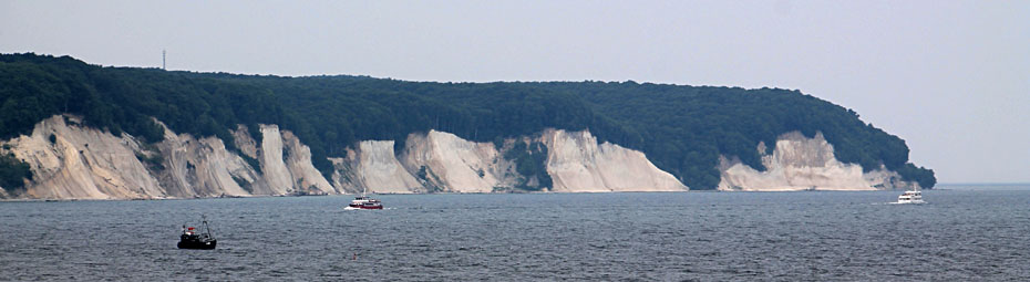
The typical morphology and structures of composite ridges are displayed quite well in the Limfjord district of northwestern Denmark (Aber et al. 1989; Klint and Pedersen 1995; Pedersen 1996). Paleogene bedrock and drift were folded and thrust into composite ridges during late Weichselian glaciation. The bedrock, consisting of
clayey diatomite interbedded with volcanic ash layers, was especially
susceptible to ice-push deformation. Large, overturned, rootless folds of
bedrock and drift were thrust up forming ridges. Ice-shoved hills display
valley-and-ridge topography, in which maximum elevations are up to 100 m
above the nearby floor of the Limfjord estuary (source basin).
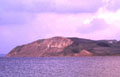
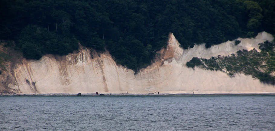
| View across Limfjord estuary toward Hanklit, a cliff exposure
on the island of Mors, northern Denmark. The cliff is about 60 m high and cuts
across the end of a large ice-shoved hill, visible behind the cliff. Photos © J.S. Aber.
|

| Hanklit reveals an overturned fold of Fur Fm. (Paleocene) bedrock,
surrounded by glacial gravel, and resting on till. Note faulting of fold core
(left) and extreme stretching of fold nose (right). Ice movement was from left
to right. |
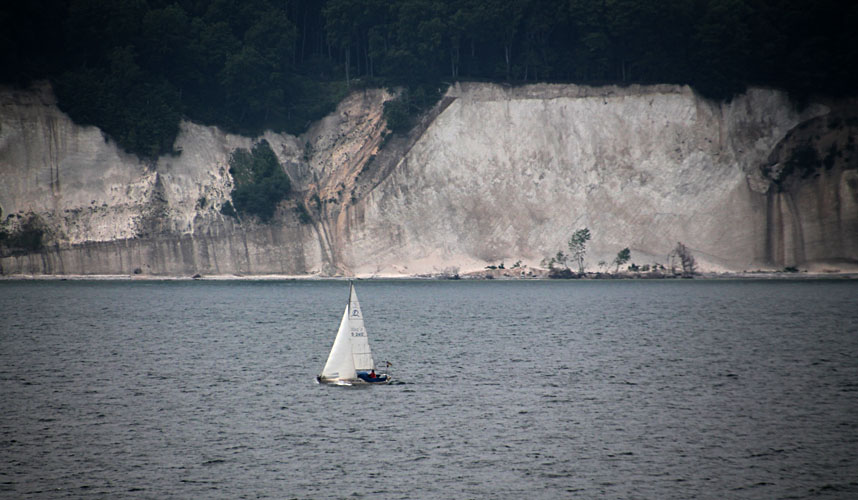
| Ice-shoved hill near Salgerhøj, inland from Hanklit,
northern Denmark. Narrow valleys alternate with ridges. Maximum elevations
are 100 m above the floor of the Limfjord estuary, visible in background (right).
The Limfjord basin was presumably the source region for material now thrust into
the ice-pushed ridges. |
 Kite aerial photographs from the Limfjord region, Denmark.
Brandon Hills are a push moraine located on the Manitoba Escarpment of
southwestern Manitoba. The hills contain a core of deformed stratified drift
with a discordant cover of till. The internal structure consists of fault
blocks or slabs of stratified drift varying from sand to cobble gravel;
no bedrock or preglacial strata are present in Brandon Hills. Brandon
Hills occupy a rectangular area roughly 10 km east-west by 4 km north-south
and reaching an elevation exceeding 590 m. Composite-ridges
covered by a thin veneer of till resemble a giant fishhook in overall plan.
A conspicuous esker resting on till loops over the eastern end of the hills,
and low kames and kettles are located to the southwest.
Kite aerial photographs from the Limfjord region, Denmark.
Brandon Hills are a push moraine located on the Manitoba Escarpment of
southwestern Manitoba. The hills contain a core of deformed stratified drift
with a discordant cover of till. The internal structure consists of fault
blocks or slabs of stratified drift varying from sand to cobble gravel;
no bedrock or preglacial strata are present in Brandon Hills. Brandon
Hills occupy a rectangular area roughly 10 km east-west by 4 km north-south
and reaching an elevation exceeding 590 m. Composite-ridges
covered by a thin veneer of till resemble a giant fishhook in overall plan.
A conspicuous esker resting on till loops over the eastern end of the hills,
and low kames and kettles are located to the southwest.
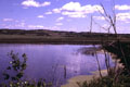
| View northward toward the distal (downglacier) side of Brandon
Hills, southwestern Manitoba. Brandon Hills are a push moraine composed entirely
of deformed glacial sediments. Lake in foreground occupies a kettle hole
south of Brandon Hills. |

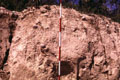
| Steeply tilted and faulted glacial sand and gravel within Brandon
Hills. The whole interior of Brandon Hills consists of such dislocated stratified
sediments, which were deformed when an ice lobe advanced into its own
outwash gravels. Scale pole marked in feet.
|
| Discordant till covers the ice-shoved ridges of Brandon Hills.
The till is sandy and contains rounded cobbles that were reworked from deformed
stratified sediment of the underlying ridges. Scale pole marked in feet.
|
Many glaciated hills have the internal structure of ice-shoved ridges, but
lack a hill-hole relationship or the typical morphology of composite
ridges. A distinctive hill of this type is the cupola hill. Cupola
hills have an internal structure similar to composite-ridges, but their
external morphology was substantially modified by overriding ice. Cupola
hills have three basic attributes.
- Interior structure: deformed glacial and interglacial strata
with or without detached floes of older bedrock.
- External form: long, even hill slopes with dome or drumlin
morphology, varying from nearly circular to elongated ovals in plan, 1-15
km long, 20 m to >100 m high.
- Discordant till: overridden by ice which truncated deformed
structures and deposited a basal till cover over hill.
Cupola hills represent the combined effects of ice-shoving and subglacial
erosion, deposition and molding of the ice-pushed hill. Where subglacial
modification is slight, a subdued composite-ridge morphology may be
preserved. With more modification, a rounded, smoothed cupola hill
results. Still greater glacial erosion may create streamlined,
drumlin-shaped hills, and eventually all trace of the
ice-shoved hill may be removed by prolonged erosion. The typical
characteristics of cupola hills are demonstrated on the island of Møn,
southeastern Denmark (Aber et al. 1989).
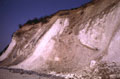
| Hvideklint cliff section on the island of Møn,
southeastern Denmark. Large masses of Cretaceous chalk are thrust and
deformed along with older glacial sediments. The dislocated materials are
capped by discordant till (brown) visible at the cliff top. Cliff is about
20 m high. |
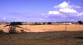
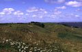
| Pastoral scene inland from Hvideklint. Gently rolling hills give
little morphologic indication of the strong glaciotectonic disturbances
beneath this cupola hill. Photos © J.S. Aber. |
Model for ice-shoved hills
A model for glaciotectonism consists of two stages: (1) proglacial
thrusting of ice-shoved hills followed by (2) subglacial modification of
overridden hills. Initial proglacial thrusting takes
place along a décollement that may be controlled by any of several
features: lower boundary of permafrost, lithologic or stratigraphic
boundary, position of confined aquifer, etc. Subglacial melt water
may either erode tunnel valleys or deposit eskers, while proglacial melt
water may cut spillways across the ice-pushed ridge and deposit outwash
sediment on the distal side of the hill.
Debris flows, small fans, ablation till and other surficial sediment may accumulate at the ice
margin, while basal till may build up under the glacier. Such sediments
often become deformed as ice movement proceeds. With continued glacier
advance, the hill may be overridden, further deformed, eroded, covered with
till, and/or molded into a cupola-hill or drumlin. All traces of the
ice-shoved hill may be eventually removed by prolonged erosion.

 Glossary or references.
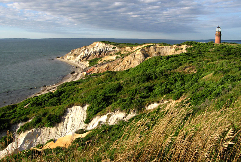
 Kite aerial photographs from Martha's Vineyard, Massachusetts.
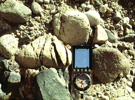
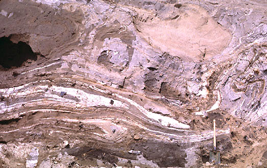


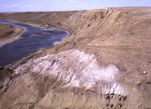

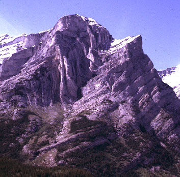

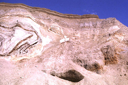
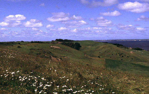

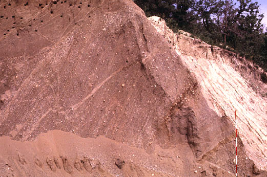


 Table of Contents