| James S. Aber |
|
| James S. Aber |
| Introduction | Fundamentals |
| Mechanisms | Erosional forms |
| Alpine glaciation | References |
The processes that shape landforms can be categorized as endogenetic or exogenetic. Endogenetic processes are related to plate tectonics and to the surface effects of plate movements, both horizontally and vertically, as well as to other processes originating from the Earth's interior. Exogenetic processes develop at or above the surface in the atmosphere, hydrosphere, cryosphere, or biosphere. They involve wind, water, ice, mass movements, or living organisms that modify landforms. Geomorphic processes associated with glaciation are among the most variable and complex of any environments at the Earth's surface.
Endogenetic and exogenetic processes combine with structure and time to produce the observed landforms at the Earth's surface. Most landforms involve a considerable mass of material, and so are slow to adapt when environmental changes take place. The geomorphology of a region, therefore, represents a long-term integration of environmental conditions and trends. A region's geomorphology is, thus, a reflection of both past and present environments.
Erosion or deposition beneath a glacier result from a complex relationship
between ice velocity, basal melting/freezing, and substratum conditions.
In general, erosion takes place under most of the accumulation zone,
whereas deposition predominates in the ablation zone. The greatest amount
of erosion takes place where ice velocity is highest, immediately inside
the equilibrium line or in concentrated flow of ice streams.
Glacial landforms comprise many kinds of features created by glacial
destruction and/or construction. Destructive landforms are the results of
erosion or deformation in which material is removed from the local
landscape. Constructive landforms are created by building up material due
to deposition or deformation. Both glacier ice and glacial melt water are
active agents of glacial landform genesis.
Large blocks of the substratum may be removed by a process called
plucking or quarrying. This takes place when blocks of the
substratum become frozen onto the ice base and are lifted up into the
glacier. Freezing on may occur where ice is advancing from thawed-bed to
frozen-bed zones either locally or regionally, and the removal of sediment
is facilitated by compressive (upward) ice flow.
Subglacial melt water is another important agent of erosion. High-pressure
water charged with sediment may be highly erosive, and can carve potholes and
distinctive hydraulic channel forms. Sudden outbursts or floods of subglacial
melt water, may remove huge volumes of sediment from beneath the glacier very
rapidly (Booth 1994). It should be emphasized that all mechanisms of glacial erosion
may operate in close association or may alternate through time at a particular site.
The locations of fjords may be related to preglacial valleys, structural
(bedrock) control, or crustal fractures (Holtedahl 1967). Fjords are the
results of combined glacier erosion and erosion by high-pressure melt water
flowing beneath the ice. The positions of fjord mouths
mark the points where the valley glaciers either began to float or could
spread out laterally, so that erosion was much less than in the confined
inland valley.
Fundamental effects of glaciers
The fundamental geomorphic effects of glaciers and ice sheets on the
landscape are threefold: erosion, deformation, and
deposition. At least two of these three
categories of features must be observed in order to demonstrate former
glaciation of a region. In order to interpret ancient glaciation, the
uniformitarian approach is crucial: modern glaciers and their erosional and
depositional features are used as analogs for understanding similar
features of older glaciations.Mechanisms of glacial erosion
Glacial erosion occurs in several ways. Abrasion is the result of
stones and grit in the basal ice grinding over the substratum. The
products of grinding are rock flour sediment and a variety of
erosional bed forms: polish, striations, grooves, fractures, and gouges. This mechanism implies basal sliding and, thus, a temperate
thermal regime with water beneath the glacier. This type of erosion is enhanced
by extensional (downward) ice flow conditions.
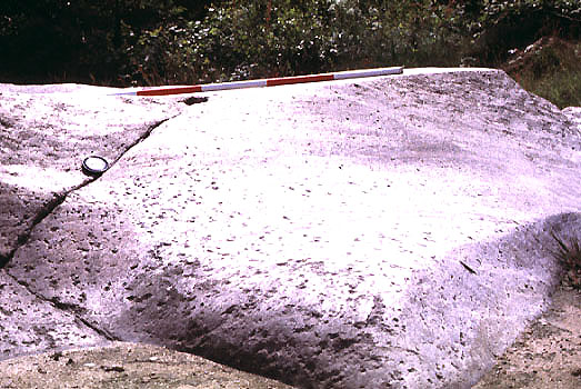
Glacial polish on granite surface, island of Bornholm, Denmark.
Subglacial grinding produced this polished surface. Ice movement
from left to right; scale pole marked in 20-cm intervals.
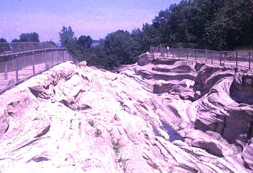
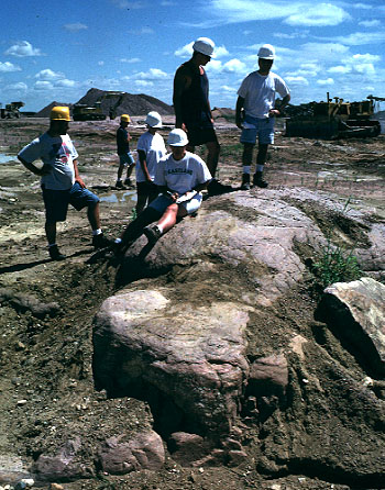
Giant glacial groove on Kelleys Island, Ohio. Many giant grooves were
once present on Kelleys Island. Photo shows about half of a preserved groove.
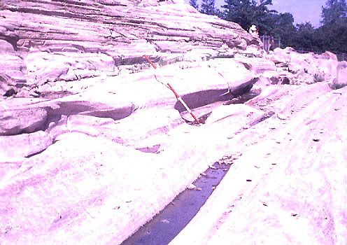
Glacial grooves on Kelleys Island are cut into Paleozoic dolostone.
The grooves were 2-6 m deep, 5-20 m wide, and 100-400 m long (Goldthwait
1979). This view depicts intricate striations and small grooves within the main channel.
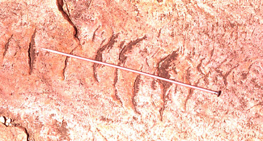
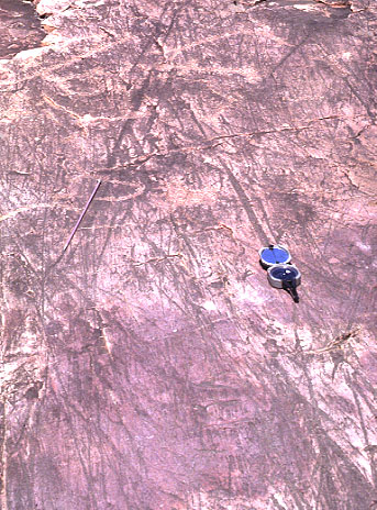
Crescentic gouges on Sioux Quartzite, southwestern Minnesota.
Such gouges are produced by ice pressing and dragging a boulder over the
bedrock surface. Ice movement in direction of needle (35 cm long); gouges are
convex in the downice direction.
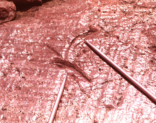
Crescentic gouges, shallow grooves and striations on Sioux Quartzite,
southwestern Minnesota. Ice movement in direction of needle (35 cm long); gouges
are convex in the downice direction.
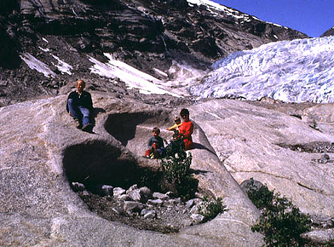
Small potholes on a rock knob in front of Nigardsbreen,
an outlet glacier of Jostedalsbreen, western Norway. These
potholes were carved in crystalline bedrock by subglacial
melt water when the glacier extended over the area.
Erosional forms
Destructive (erosional) landforms range in size from small abrasion marks
(mm to cm deep), to grooves and channels (m to 10s m deep), to valleys and
basins (100s to 1000s m deep). Chamberlin (1886) compiled the largest and
still best set of field observations concerning glacial striations and
grooves. He recognized three dominant types of striations, those
which:
Striations and grooves are often used to establish the direction of ice
movement at the time of erosion both locally and regionally. Glaciations with shifting directions of movement can create complex
patterns of crossing striations. In some cases, it is possible to determine
the relative age (order) of ice movements by cross-cutting erosional forms.
Prolonged glacial erosion may ultimately strip large regions of all soft
sedimentary cover so that vast shields are created.
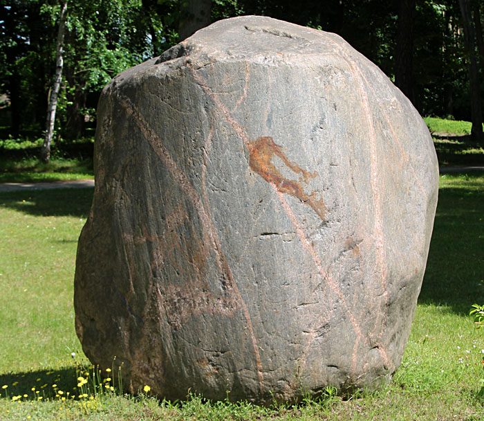
Large glacial erratic displays striations and grooves as well as various types of fracture marks. Obrzycko, west-central Poland.
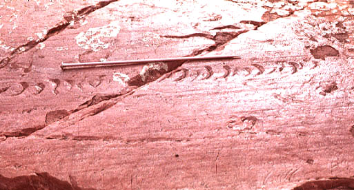
Crossing sets of striations on Sioux Quartzite, Jeffers Petroglyphs, southern
Minnesota. Needle and compass mark ice movement directions, which differ by about
30°. Ice movement toward bottom of view.
Crossing crescentic gouges on Sioux Quartzite, southwestern Minnesota.
Part of the upper gouge is truncated by the lower gouge; the upper gouge
is older, the lower one is younger. Needles indicate directions of ice
movements, which differ by about 50°.
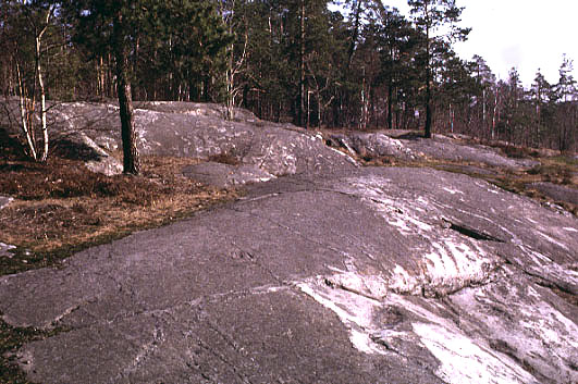
Glaciated crystalline bedrock
of the Fennoscandian shield, Stockholm, Sweden. This view is directed
downice; note polished and smoothed stoss surfaces (compare with image below).
Glacial grinding and abrasion took place on the stoss sides of bedrock
knobs.
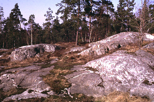
Glaciated crystalline bedrock. This view is in
upice direction; note rugged "stairstep" form of lee surfaces (compare
with image above). Plucking (quarrying) occurred on lee sides of obstacles.
View of small roche moutonée formed on Sioux Quartzite near Jeffers, southern
Minnesota. View is parallel to long axis of knob, which stands about 1 m above the
adjacent glacial pavement. Smoothly streamlined upice end, top, and sides are visible.
Ice movement toward background of view. This bedrock knob was freshly exposed when
photographed. Alpine glaciation
Glaciated mountains display many typical forms created primarily by erosion.
Ice-carved valleys display a U-shaped cross profile: steep side walls with
truncated spurs and a gently rounded to flat valley floor. Hanging valleys and waterfalls
are often found along the sides of deep glacial valleys. The longitudinal profile of a
glacial valley usually consists of a series of basins separated by rock barriers
(riegels) or moraine sills. The heads of alpine glacial valleys are often marked
by ampitheater-shaped cirque basins, and where cirques converge on mountain sides,
narrow arêtes (ridges) or horns (peaks) are left as residual features. Lakes are extremely
common within cirques and formerly glaciated valleys, because of various rock basins and
moraine dams.
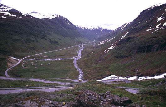
Glaciated valley, near Voss, western Norway. View from head of the valley
in downice direction. Note steep valley sides and gently rounded valley
floor—classic U-shaped valley cross profile. Also notice highway zig-zag
turns up the valley head in foreground.
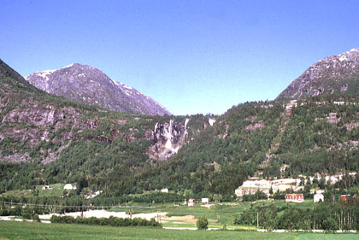
Waterfalls spill from a hanging valley on the side of a deeper valley.
Geisdalsfossen, western Norway.
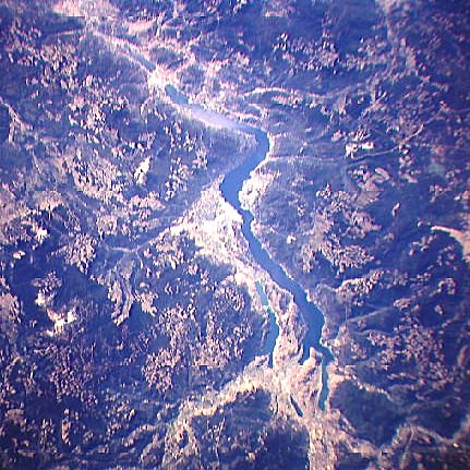
Okanagan Lake, British Columbia. NASA space-shuttle photograph,
STS068-155-011, 10/01/94, 5-inch format. Low-oblique view to south.
Lake Okanagan valley is a deeply eroded glacial trough in the Canadian
Rocky Mountains. NASA Johnson Space Center, Imagery Services.
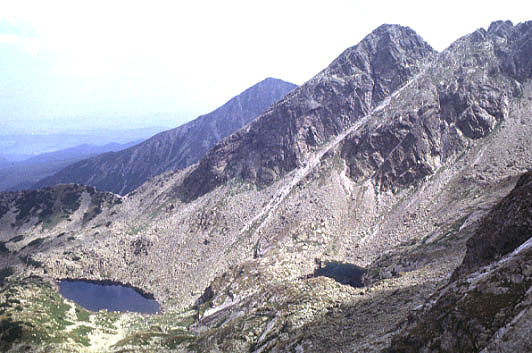
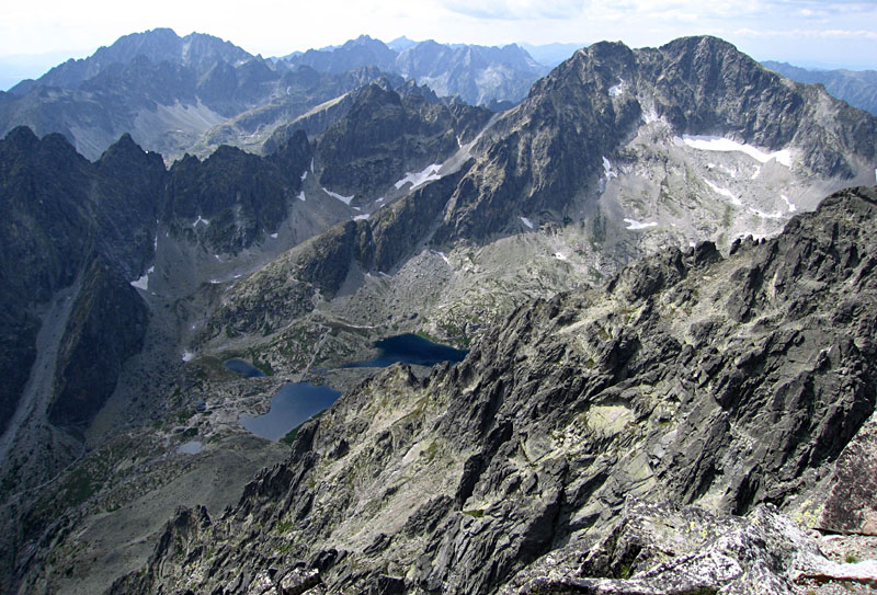
Small, lake-filled cirques in Tatra Mountains, southern Poland. The
upper cirque (right) is separated from the lower one by a rock barrier.
Each rock basin was excavated by a small cirque glacier.
For more information on the Tatras—go to Tatra Mountains.
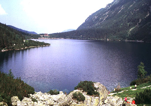
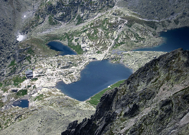
Morskie (Lake) Oko, Tatra Mountains, southern Poland. This alpine lake
is dammed by a massive end moraine, located on the far side of the lake
in this view over one of Poland's most popular tourist destinations.
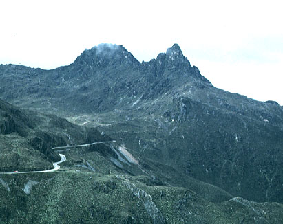
View of Píco Aguila, Andes Mountains, Venezuela. This steep peak is a horn
created by erosion of cirque glaciers in surrounding valleys. The peak reaches
more than 4000 m altitude.
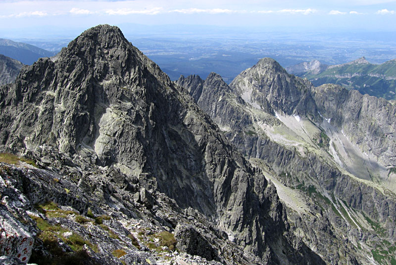
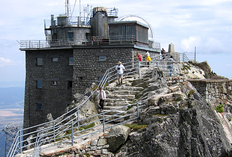
Spectacular horns, arętes, deep valleys, and small lake basins as seen from the observatory atop Lomnica, the second highest peak (2634 m) in the Tatra Mountains, Slovakia. All photos © J.S. Aber.
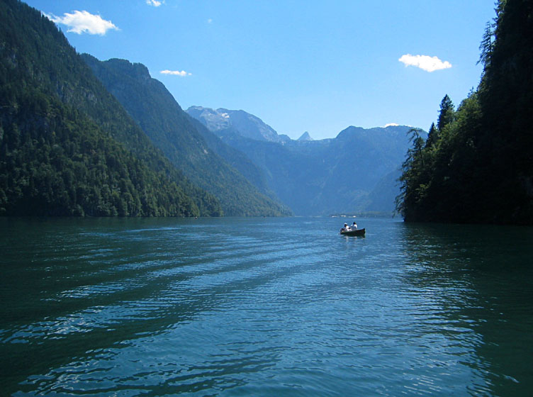
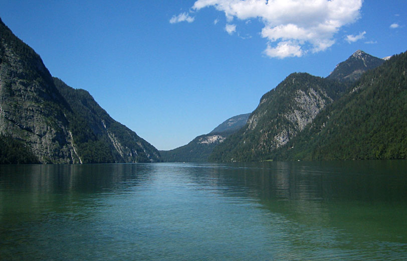
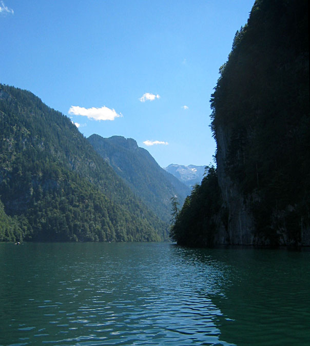
Views of Königssee, a lake in a deep ice-carved valley on the northern side of the Alps, Berchtesgaden national park, southern Germany.
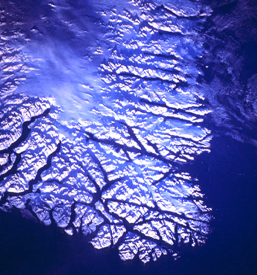
Space-shuttle photograph of southern tip of Greenland. Low-oblique view toward north,
color-visible, 70-mm format, 12/88. All land areas are snow covered in this
mid-winter scene. Deep glacier-carved fjord valleys cut through the coastal mountain ranges.
The fjords define straight paths and meet at angular junctions, which indicate that glacial
erosion followed crustal fractures. NASA Johnson Space Center, Imagery Services, STS027-36-49.
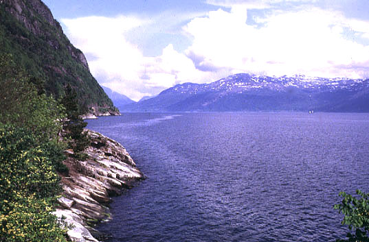
View over interior portion of Hardangerfjord, western Norway. This is the
deepest portion of the fjord—water depth more than 800 m, located 100 km
inland from its opening to the sea. Note ship on far side of fjord for
scale.
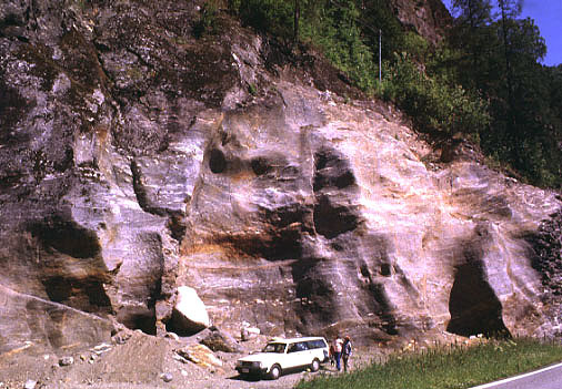
Giant "half potholes" on side of Granvin valley, a tributary to
Hardangerfjord, western Norway. Sculpted side of valley was carved
by high-pressure melt water flowing between the glacier and valley wall.

Closeup view of single pothole, which is carved into metamorphic bedrock,
Granvin valley, Norway (see above).
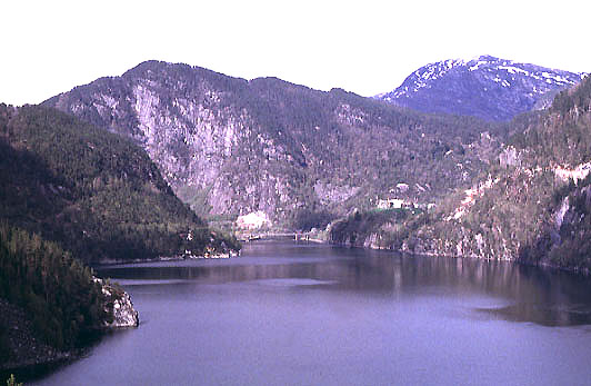
Overview of Bolstadfjord, an interior fjord of western Norway. The
main fjord basin is 100s of m deep in center. The fjord's entrance is located
at the far end of this view (see below).

Closeup view of Bolstadfjord's mouth beneath the bridge. The entrance is
narrow and quiet shallow; notice tidal current flowing out of fjord (to left).

 Glossary or references.
Return to Glacial geomorphology (2020).
All images and text © J.S. Aber.
 Table of Contents