| and ice sheets James S. Aber |
| Glacier ice | Glacier budget |
| Glacier movement | Columbia Ice Field |
| Greenland Ice Sheet | Antarctic Ice Sheets |
| Ice-sheet meteorites | Polar science online |
|
| and ice sheets James S. Aber |
| Glacier ice | Glacier budget |
| Glacier movement | Columbia Ice Field |
| Greenland Ice Sheet | Antarctic Ice Sheets |
| Ice-sheet meteorites | Polar science online |
 National Snow and Ice Data Center.
 Satellite Image Atlas of Glaciers.
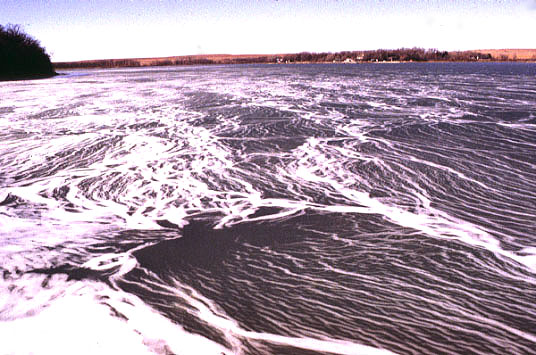
| Ice on Lake Kahola, east-central Kansas. The swirling, frothy appearance was created by freezing of foam (bubbles) into the ice. © by J.S. Aber. |
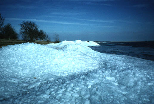
| Broken shards of ice piled on shore of Melvern Reservoir, east-central Kansas. Lake ice froze during an extended cold period—temperature <10°F, and then was broken up by wind and wave action. © by J.S. Aber. |

| Closeup view of ice shards piled on shore of Melvern Reservoir. Fragments are 3-4 inches (10 cm) thick. Individual ice crystals are oriented in a vertical position within shards, which indicates the ice formed by freezing from the lake surface downward. © by J.S. Aber. |
Glacier ice is formed by a process of snow metamorphism, which may be accompanied by seasonal melting and refreezing in some glaciers. The transition from new-fallen snow to glacier ice takes place over a period of years as the snow becomes buried and gradually recrystallized. The process is evident in three main stages:
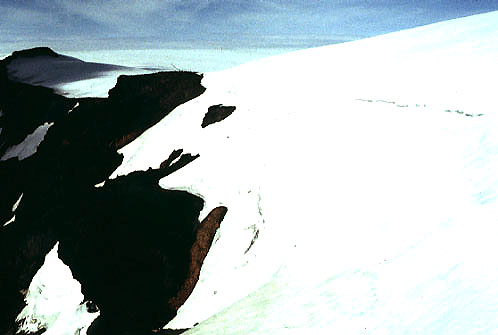
| View of firn exposed on the margin of accumulation zone in Vatnajökull, Iceland. Notice banding and bright white color. This firn section represents several years of snow accumumlation. © by J.S. Aber. |

| View inside glacier cave on Mt. Rainier, Washington. Typical blue-green (cyan) color of dense glacier ice is visible. Photo © PANA-VUE (S1979). |
Loss of mass, or ablation, takes place by melting at the surface, within, or beneath a glacier. Melt water may exit under pressure from the snout of a glacier, thus forming springs and fountains. Glaciers that enter lakes or seas may also lose mass by calving off icebergs. Some glaciers in extremely cold, dry climates lose mass by wind erosion and direct sublimation.
The higher, central surface of most glaciers is the zone of accumulation, also called the névé, in which firn is present. The ablation zone is located in the lower, marginal portions of glaciers. The accumulation zone is considerably larger in area than the ablation zone for most glaciers. Any healthy glacier will, over an extended time, have a budget in which accumulation equals or exceeds ablation. As the volume of accumulation and ablation in a single year is only a tiny fraction of the total mass of most glaciers, yearly variations in net accumulation are not significant. Small glaciers respond to climatic changes of decade-long duration, whereas large ice sheets take centuries to react to climatic changes.
Glaciers that have a "warm" base at the pressure-melting temperature also move by basal slip. In effect the glacier rides on local films or small pools of water that support and lubricate ice movement. Most alpine and maritime glaciers move by a combination of internal deformation and basal slip. However, the contribution of each movement mechanism may vary substantially between nearby glaciers and even within different parts of a single glacier. Seasonal variations also take place in glacier flow, as illustrated by Forbes bands. In some cases, subglacial melt water may build up so much that nearly all the glacier is floating, or a deformable bed of high-pressure, fluidized sediment may form. When this happens, rapid ice advance, called a surge, may take place. Surging glaciers have been known to advance at rates >100 m/day. During a surge, much mass is quickly transferred from the accumulation area to the ablation zone during a period of weeks or months. The glacier usually remains stagnant for several years after a surge. Certain glaciers surge periodically, whereas other nearby glaciers never surge. Surges have not been observed in ice sheets, but surging is considered an important possibility for ice-sheet movement. The Bering Glacier, Alaska began to surge between March and May 1993. During the next several months, the surge affected more than half of the glacier's 5,175 km² area. Surge-related features included: deeply crevassed bulges and pressure ridges, extensional fractures, intricate patterns of crevasses, tear faults, ephemeral lakes, etc. The ice margin advanced in places more than 1500 m into a proglacial lake, and the rate of advance approached 100 m/day. Bering Glacier is one of more than 200 temperate glaciers known to surge in the western United States and Canada. Surging glaciers also are quite common in eastern Canada, Iceland, and on the archipelago of Svalbard.
Dry-snow facies covers the high, central and northern portions of the ice sheet. Percolation facies covers most of the southern portion and lower northern parts; wet-snow facies is found only in a narrow marginal zone. A narrow marginal zone of the ice sheet is subject to loss, mainly by melting on land and by calving of icebergs where ice reaches the sea in large fjords.
Several attempts have been made to estimate the ice-sheet budget. These attempts were difficult in the past because of the great size of the ice sheet and limited information concerning accumulation, melting, and calving of icebergs. Remote sensing observations have improved our ability to gauge changes in the ice sheet. Altimeter measurements from the ERS-1 and ERS-2 satellites documented an overall increase in elevation of the ice surface during the period 1992-2003 (Johannessen et al. 2005). Throughout the vast interior of the ice sheet, surface elevations increased at an average rate of ~6˝ cm/year. The narrow marginal zone suffered a decrease at ~2 cm/year. Over the whole of the ice sheet this represents an average increase of ~5˝ cm/year, or 60 cm total for the 11-year period of observation. When corrected for crustal depression, the total increase is estimated to be 54 cm. In other words, the Greenland Ice Sheet has gained more than half a meter of surface accumulation overall since the early 1990s, which suggests a strongly positive budget.
Ice movement is generally downward and outward from two major domes in the east-central and southern portions. Movement within most of the accumulation zone is slow, only a few m/year, with movement increasing to about 80 m/year near the firn line. The two domes are separated by a lower saddle from which several fleuves de glâce flow westward. These concentrated, high-velocity ice streams follow subglacial valleys leading westward to Disko and Umanak Bays, where a large volume of icebergs is discharged. Near the calving margin, ice-flow velocities are 2-10 km/year, and much melt water emerges from beneath the ice.
On the continental shelf, sea level was some 100-150 m lower, so some banks were exposed as dry land at the edge of the ice sheet. The ice sheet may have been confluent with the Ellesmere Ice Cap to the northwest, although this is a debatable interpretation. During maximum glaciation, the coastal areas were depressed as a result of ice loading on the crust; these areas have now rebounded by 50-200 m.
The ancestral Jakobshavn ice stream expanded several 100 km to the shelf edge on the western side of Greenland at the last glacial maximum ~20,000 years ago (Cofaigh et al. 2013). It began to retreat by 14,800 calibrated-years ago; however, it readvanced significantly during the short-lived Younger Dryas phase about 12,000 calibrated-years ago.
It is generally thought that the Greenland Ice Sheet formed in the late Pliocene or early Pleistocene by coalescence of ice caps and glaciers. New evidence from offshore marine deposits suggests that Greenland had a partial ice cover as far back as seven million years ago (late Miocene). The marine deposits contain large stones transported by drifting icebergs derived from Greenland glaciers.
Marine-based ice sheets are inherently unstable. Such an ice sheet is held in check by back stress from the adjacent ice shelf by shear stress at basal pinning points and along lateral margins. A slight rise in relative sea level (crustal subsidence), decrease in ice flow, or thinning of the ice shelf would reduce the back stress and could lead to rapid collapse of the ice sheet (Alley 1989). Antarctic ice shelves are sources of enormous tabular icebergs.
The West Antarctic Ice Sheet is drained by a series of ice streams that feed into the Ross Ice Shelf. These ice streams flow through a region of relatively thin ice (about 1000 m), but they maintain flow rates of around 500 m per year, and they accelerate downstream. They are characterized by highly crevassed surfaces in contrast to the adjacent smooth surface of slow-moving ice. The individual ice streams appear to have complex and different histories of movement. For example, ice stream C seems to have stopped moving around 100 years ago. Most of the rapid motion of ice streams is accomplished by basal sliding over water-lubricated beds or by deformation within a thin, water-saturated sediment layer below the ice (Alley 1989).
The Ross Ice Shelf has fluctuated considerably during the past 45,000 years. Between 45,000 and 27,000 years ago, the ice edge was quite similar to now, then expanded reaching a maximum position ~13,000 years ago. During the Holocene, the ice margin retreated considerably reaching a minimum position in the middle Holocene between 4000 and 2000 years ago.
Antarctica was glaciated much earlier than was Greenland. A semipermanent ice sheet was established by the end of the Eocene or earliest Oligocene, about 34 million years ago (Ivany et al. 2006). Glaciation in other high-latitude southern lands also started early. Tasmania supported local glaciers in the early Oligocene, around 36 million years ago, when it was a mountainous peninsula of Australia at about 55-56°S latitude (Macphail et al. 1993). The Antarctic ice sheet experienced a major expansion during the early Pliocene, 5-4 million years ago (Bart 2001). This expansion took place in spite of relatively high sea level and warm temperature globally, and the ice volume may have been significantly larger than present ice volume.
Glacier budget
The glacier budget is a balance of mass gains and losses during the course of a year. Accumulation of snow is the primary means by which most glaciers gain mass. Snow may accumulate from direct air fall, or may be blown or avalanched from adjacent areas. Freezing rain, hail, hoarfrost, or other forms of ice accumulation are negligible.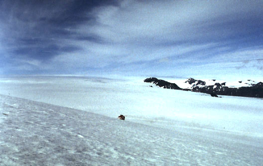
View over portion of névé, accumulation zone on Vatnajökull,
Iceland.
Snow tractor/sledge in center for scale. © by J.S. Aber.Glacier movement
Glaciers move. Glacier movement was illustrated dramatically in 1991, when the mummified body of a Bronze Age man emerged from a glacier in Austria. Similar accounts of bodies and artifacts carried by glaciers have been documented for many other sites. For a glacier in balance, it is necessary to transfer material from the accumulation area to the ablation zone in order to maintain a constant surface. Ice-flow velocities vary from imperceptible to several m/day, although most glaciers move <1 m/day. The following general ice movements are developed in most glaciers.
Glaciers move in three ways: internal deformation, basal slip, and deformation of the substratum. Below the shallow surface zone of crevasses, ice behaves in a plastic manner, flowing in response to the pressure gradient. The rate of flow depends on several factors, of which temperature and pressure are most important. Warmer ice generally flows more readily than colder ice, and ice under greater pressure is softer than ice at lower pressure. Because of this, most movement by plastic flow takes place near the base (lowest 100 m) of glaciers. This explains how "cold" glaciers that are frozen to the substratum are able to move, and why many glaciers move faster in the summer than in the winter.Columbia Ice Field
The Columbia Ice Field is the largest glacier complex in the Rocky
Mountains south of Alaska today. It is located on the continental divide in Alberta and British Columbia. The accumulation zone is situated on mountain plateaus and generally exceeds 2500 m elevation. Snow Dome, the high point of the ice field, reaches 3460 m (>11,000 feet) and represents the triple point in the drainage divide system of North America: Arctic, Atlantic, and Pacific.
Scale model of Columbia Ice Field, B.C./Alberta, Canada.
View straight down from above ice field; south toward top.
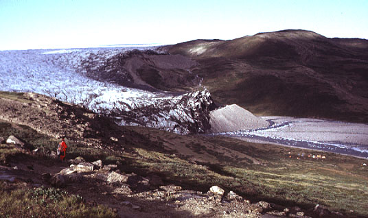
Telephoto view of Saskatchewan Glacier descending into valley from the
Columbia Ice Field (background). Glacier is fed by two streams, whose boundary
is marked by a medial moraine (dark stripe) on the ice surface. The ice
front is a few 100 m (several 100 feet) high.
Photo © by J.S. Aber. Greenland Ice Sheet
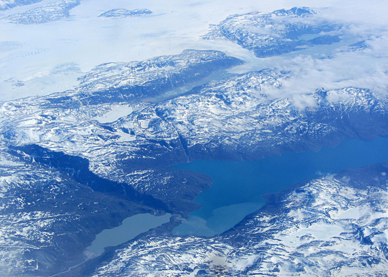
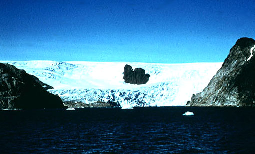
The Greenland Ice Sheet covers an estimated area of 1.7 million km² and is the second largest ice sheet existing today—see title image. Its maximum dimensions are 2460 km N-S, 1100 km E-W, and >3000 m elevation, with an average thickness of about 2 km Weidick (1975). The ice sheet represents about 11% of the total volume of glacier ice in the world today, an amount equivalent to 6 m of sea-level rise.
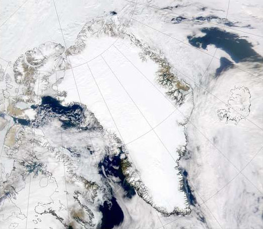
SeaWiFS satellite image over the whole of Greenland. Date 07/15/2000; obtained from NASA's Visible Earth.
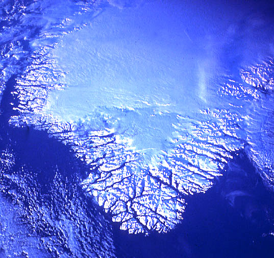
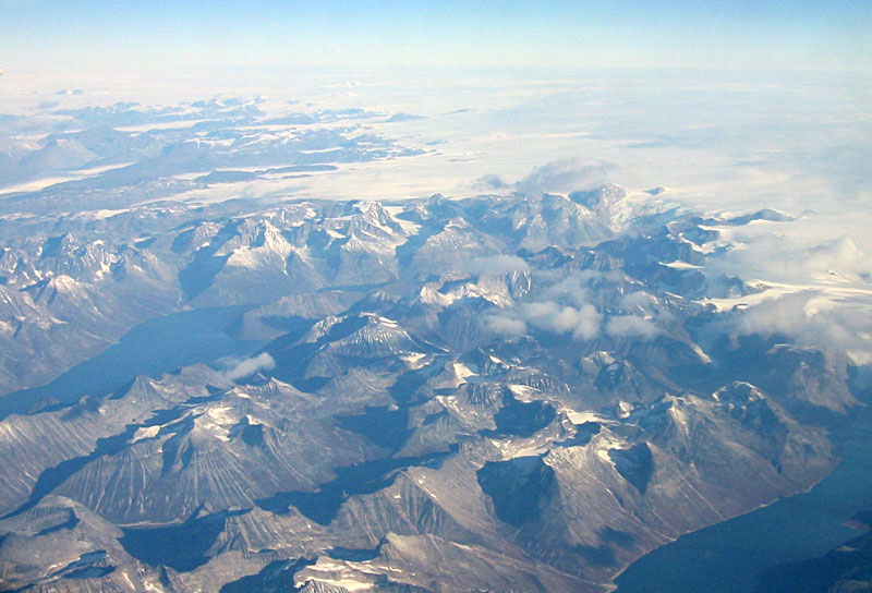
Space-shuttle photograph of southern Greenland. Low-oblique view toward north,
color-visible, 70-mm format, 12/88. All land areas are snow covered in this
mid-winter scene. The interior ice sheet is smooth, and coastal mountains appear
rugged. Deep glacier-carved fjord valleys cut through the coastal mountain ranges.
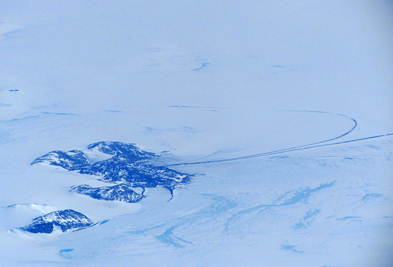
NASA Johnson Space Center, STS027-32-17.  Southeastern margin of Greenland
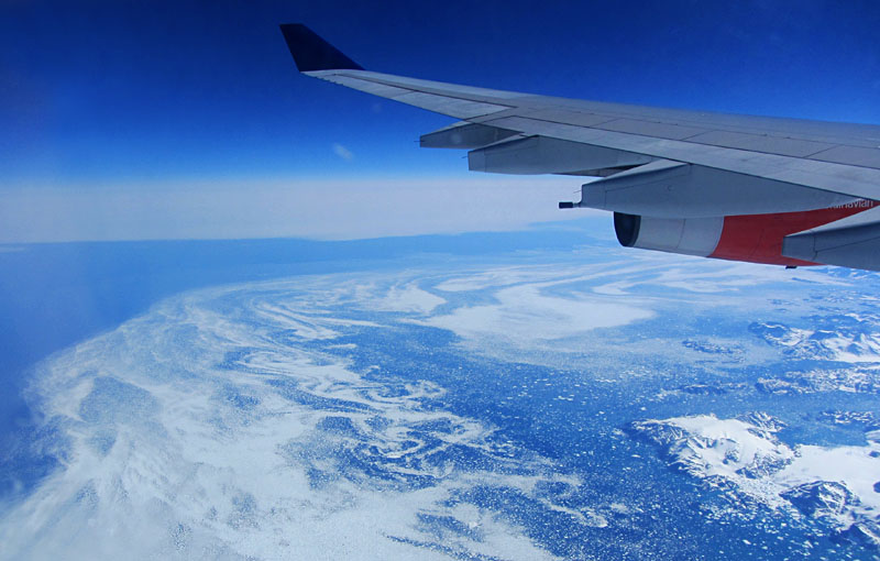
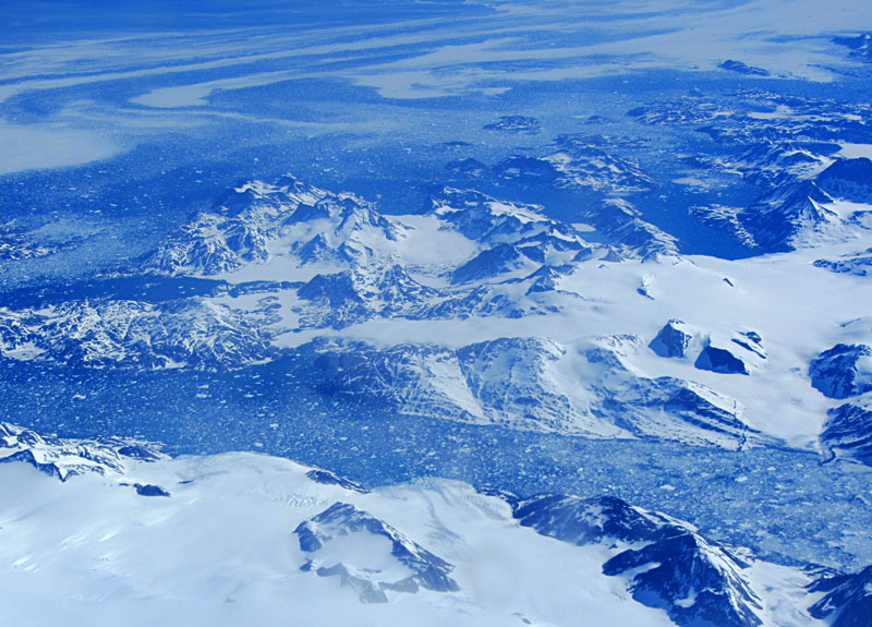
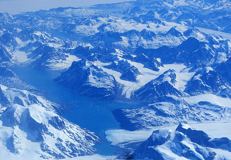

Images © S.W. & J.S. Aber. Southwestern margin of Greenland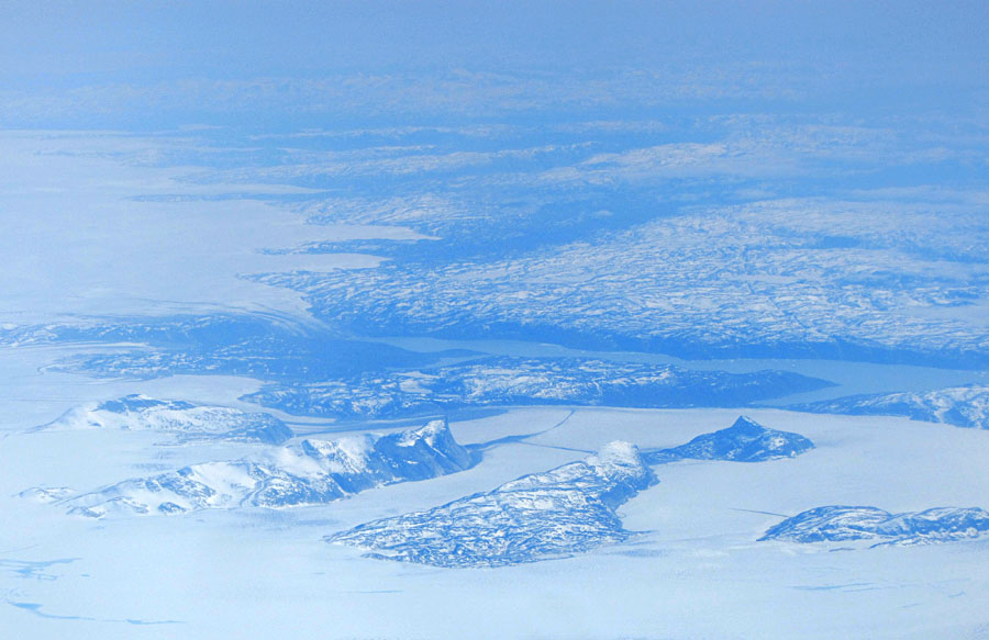
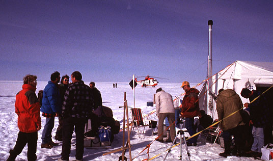
Research camp of the Free University of Amsterdam (Netherlands) on the Greenland ice
sheet. The surface is hard frozen snow and ice, but percolation melt water collects about
½ m below the surface. Foot pressure is sometimes enough to break through the hard surface,
and people suddenly find themselves knee-deep in slush.
Photo © by J.J. Zeeberg; used here by permission. 
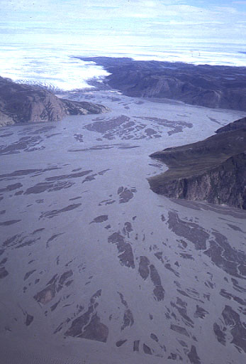
Overview of margin of Greenland ice sheet. Note braided streams of melt water flowing
over the broad valley. Thick outwash sediment of sand and gravel accumulates on the valley
plain or sandur. Photo © by J.J. Zeeberg; used here by permission.
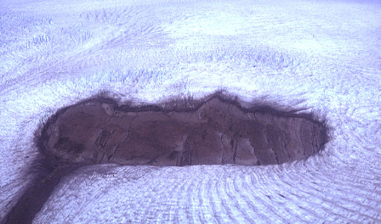
Outwash valley plain almost completely covered by sediment-laden melt water.
Photo © by J.J. Zeeberg; used here by permission.
Outlet glacier on Greenland's west coast. This glacier and many others break off
as icebergs, a process called glacier calving. Photograph by Preben Jensen,
Denmark; reproduced here by permission.
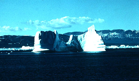
View of massive iceberg floating in coastal waters of western Greenland.
Only about 10% of the iceberg's volume is visible, the rest is below sea level.
Photograph by Preben Jensen, Denmark; reproduced here by permission.
Aerial view of a modern nunatak surrounded by the Greenland ice sheet.
Note crevasses and pressure ridges in ice around the nunatak.
Ice flow from upper right toward lower left of view is indicated by
the medial moraine extending away from the nunatak.
Photo © by J.J. Zeeberg; used here by permission.
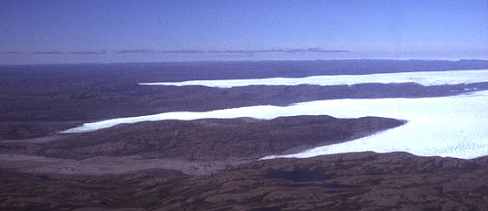
Overview of margin of Greenland ice sheet; outlet glaciers extend into valleys toward
the left. The longest of these is the Russell Glacier.
Photo © by J.J. Zeeberg; used here by permission.
Russell Glacier. Note the lateral moraine (far side of valley) and push moraine (glacier
snout). The push moraine is composed of sand and gravel shoved up from the sandur plain.
Research camp of the University of Amsterdam and Utrecht University (Netherlands) is visible
in the lower right part of view. Photo © by J.J. Zeeberg; used here by permission.
Antarctic Ice Sheets
The Antarctic continent is 95% ice covered, and large ice shelves extend into adjacent Ross and Weddell Seas. Two ice sheets are actually present: the East Antarctic Ice Sheet and the smaller West Antarctic Ice Sheet. They are separated by the Transantarctic Mountains. The East Antarctic Ice Sheet represents about 60 m of sea-level equivalent, and the West Antarctic Ice Sheet contains water equivalent to another 5 m of sea level rise (Alley 1989).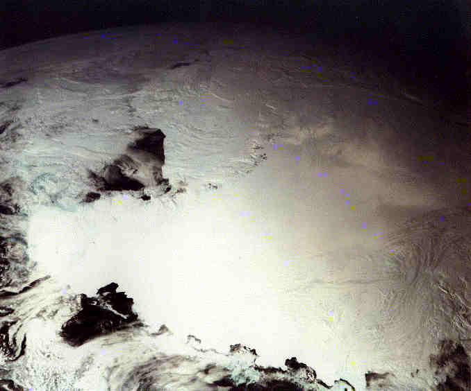
Antarctica—a mosaic of 40 Galileo images taken through red, green, and violet filters.
Antarctica is about 4000 km across from top to bottom of view. The South Pole is just right
of center, and Ross Ice Shelf is just above the center. Dark zones are open-water seas around
the margin of the ice sheet. Derived from NASA Goddard Space Flight Center, Earth-Galileo
imagery.  Landsat image mosaic of Antarctica—LIMA.
Ice-sheet meteorites and cosmic dust
Many meteorites have been found in Greenland, especially in the Thule area. The same is true for Antarctica, where literally thousands of meteorites have been collected from the surface in "blue ice" areas. In fact, the number of meteorites found during the past few years in Antarctica is about 25% of all meteorites ever found worldwide. It is estimated that more than 750,000 meteorites lie buried within the ice sheet (Lucchitta et al. 1987). Ice flow locally concentrates meteorites at the surface in areas of strong wind ablation, where ice is locally trapped behind mountains.
Large nickel-iron meteorite, named Agpalilik, recovered from the edge of
the Greenland ice sheet, near Thule. The meteorite is about 4 feet (1.2 m)
long, and was one of several larger and smaller fragments found in the
vicinity. This specimen on display at the Geological
Museum, Copenhagen, Denmark. Photo © J.S. Aber. 
Polar science on the Web
The Arctic and Antarctic regions have the harshest climates and the most fragile environmental conditions on Earth. Diverse scientific investigations are underway by many nations on glaciology, meteorology, biology, oceanography, and geologic history.
 Glossary or references.
Return to Glacial geomorphology (2020).
All images and text © J.S. Aber.