Historical development of glacial theory
The earliest known descriptions of glaciers were recorded in the 11th century in Viking Iceland, which was named not for its ice caps but for the coastal sea ice. Icelandic glaciers as well as sea ice and volcanoes are depicted on a map made by Bishop Thorláksson sometime before 1585; it is the oldest known map on which glaciers (jökull) are portrayed. Systematic observations of Icelandic glaciers were carried out by Sveinn Pálsson in the 1790s. He was a physician and naturalist, who lived during a time of great poverty in Iceland. He observed volcanoes, glaciers, and wildlife throughout the island.

| Photograph of Sandfellsjökull, an outlet glacier of
Mýrdalsjökull ice cap, southern Iceland. The margin of the glacier is quite dark from a cover of debris. |
Pálsson reached significant conclusions concerning formation and dynamics of glaciers. He recognized that glaciers move by creep in a way analogous to the flow of pitch. He dealt with glacial sediments, melt-water rivers and floods, and the effects of subglacial volcanism. Pálsson's treatise was sent to the Danish Society of Natural History in 1795, but it was forgotten at the time and not published until nearly a century later (Ingólfsson 1991). Iceland remained a remote location for geological investigations until the 20th century.
The concept of former extension of glaciers and ice sheets began to develop in the late 18th and early 19th centuries in the Alps of central Europe and the mountains of southern Scandinavia. Many early mountaineers, naturalists, and scientists were involved, of which several played key roles. Horace-Bénédict de Saussure was among the earliest naturalists to undertake systematic observations of glaciers in the Mont Blanc vicinity beginning in the 1760s. His work culminated in Des glaciers en général, which was published in volume 1, chapter VII of his Voyages dans les Alpes (1779). In this synthesis, he reviewed types of glaciers, ice flow, origin of moraines, and many other aspects of glaciers.
Saussure introduced the terms roches moutonnée, sérac, and moraine into geological usage (Carozzi and Newman 1995).
James Hutton was first to recognize in 1795 that erratic granite boulders in the Jura Mountains had been transported by glaciers from the Alps (Flint 1971). Such erratics were then commonly believed to be results of a great flood, whence the term drift was derived. This term is still in general use for any kind of glacially derived sediment.
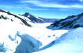
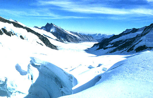
| Aletsch Glacier, central Swiss Alps. View from near head looking down
ice along glacier. This is the largest glacier in the Alps today; it
extends some 20 km downvalley. Photo © by Foto Meier, Thun |
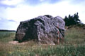
| Photograph of large erratic boulder in western Denmark. The boulder is crystalline
rock transported by glaciation from the mountains of southern Norway. Scale pole
marked in 20-cm intervals. The erratic block is approximately 6.5 m long. |
In Scandinavia, Jens Esmark concluded in 1824 that glaciers had once been much larger and thicker, and had covered much of Norway and the adjacent sea floor (Andersen 1992). He made observations in the central mountain district as well as on coastal plains and fjords. He attributed erratics and moraines to glacial transportation and deposition. He also recognized that glaciers were powerful agents of erosion that had carved out the Norwegian fjords (Cunningham 1990).
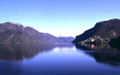
| View northward along Veafjord, western Norway. City of Vaksdal to right.
Fjord is some 25 km long, 2 km wide, and several 100 m deep (below sealevel).
This fjord was eroded along a major fracture zone in crystalline bedrock. |
| Photograph of glacial striations and grooves on Sioux Quartzite bedrock at Jeffers,
Minnesota. Two directions of ice movement are indicated by crossing (x) pattern of
striae. Silva compass for scale. |
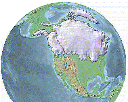
In the early 1830s, Jean de Charpentier began to marshall the scientific evidence for former alpine glaciation. He observed moraines, striations, and erratics, as well as existing glaciers of the Swiss Alps, and presented his conclusions in a very persuasive manner (Teller 1983). His ideas initially met with much skepticism, but his work eventually became quite influential. One of those who at first disbelieved de Charpentier was Louis Agassiz, who was already a famous zoologist. Through his own observations, Agassiz came to accept the concept of former alpine glaciation, and then carried the idea much further. In 1837 he proposed that vast sheets of ice had once covered much of the northern hemisphere. This was a radical suggestion, for at that time the modern ice sheets in Greenland and Antarctica were completely unknown.
Agassiz was a highly energetic and controversial naturalist and writer, who popularized the idea of a geologically recent ice age as the latest catastrophe in Earth history. By the mid-1800s, the glacial theory existed at three levels:
- Alpine glaciers: Modern glaciers in the Swiss Alps and Norway had once extended farther down their valleys than today = uniformitarian process, local events.
- Mountain ice caps: Glacier cover in the Swiss Alps and Norway had once been much thicker (or mountains higher) so that ice caps formed and spread into adjacent regions = extended uniformitarian process, regional events.
- Continental ice sheet: Vast sheet of ice spread from the Arctic and covered all of Europe as far south as the Mediterranean (also in North America) = global catastrophe and biologic extinctions.
Agassiz undertook detailed studies of glacier movement on the Unteraar Glacier in Switzerland in the 1840s, and he influenced James D. Forbes (Scotch) to begin similar glaciologic research in the French Alps. Forbes established that glaciers move in part by internal viscous (plastic) deformation, in contrast to the more popular dilatation or regelation theories of the day. Forbes was also first to recognize the annual dirt bands that mark glaciers below ice falls. These bands are commonly called ogives, but are more properly named Forbes bands (Cunningham 1990, p. 293). The glacial theory was initially opposed by a sizeable number of natural scientists, who prefered to interpret landscape features as the results of a great biblical flood. Some glacial deposits in former marine areas do in fact contain fossil shellfish. During the next few decades, those who opposed the glacial theory were either converted or died. The effects of glacial erosion and deposition were observed widely in Europe, the British Isles, and in North America. Charles Lyell (1863) recognized that glaciers also could deform sedimentary
strata.
| Photograph of chalk-till mélange from West Runton, England. Chalk
and till were sheared and mixed together by strong glacial deformation. Red pocket
knife for scale. |
The Norwegian Fridtjof Nansen provided final proof for the existence of ice sheets, when he crossed the southern portion of the Greenland Ice Sheet in 1888. The geography of Greenland had been the subject of several expeditions and intense debate prior to Nansen's journey. He suceeded in crossing the ice sheet, where many earlier attempts had failed, by skiing and using survival techniques of the Lapps and Eskimoes. Another Norwegian explorer, Roald Amundsen, was the first person to reach the South Pole in 1911.
 Table of Contents
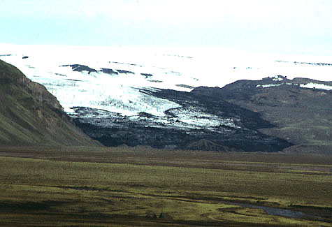


 Related sites