| Missouri River |
| Introduction | Missouri and Kansas |
| Nebraska and Iowa | South and North Dakota |
| River conditions | Related sites |
|
| Missouri River |
| Introduction | Missouri and Kansas |
| Nebraska and Iowa | South and North Dakota |
| River conditions | Related sites |
The images are arranged below in progression, beginning at St. Louis and continuing upstream to Lake Sakakawea in central North Dakota. All images are oriented in the UTM grid, and images are annotated with selected geographic features. Individual images vary in size and shape, depending largely on position of the Missouri River. Each image has a scale bar showing 25 kilometers (~16 miles). Sites of interest are numbered on each image in an upstream direction. Click on small images to see larger versions (370 to 530 kb).
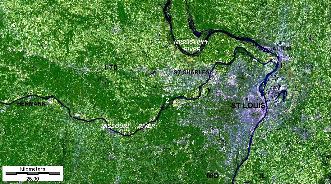
| St. Louis and St. Charles vicinity, Illinois and Missouri. Landsat TM 257 composite; image date 13 July 1997. 1 - Approximate location of Camp Wood, opposite the mouth of the Missouri. 2 - Howell Island and Weldon Spring Conservation Areas. Lewis and Clark's winter camp for 1803-04 was destroyed long ago by flooding, and the mouth of the Missouri has migrated. The Corps of Discovery departed Camp Wood on May 14, 1804. |
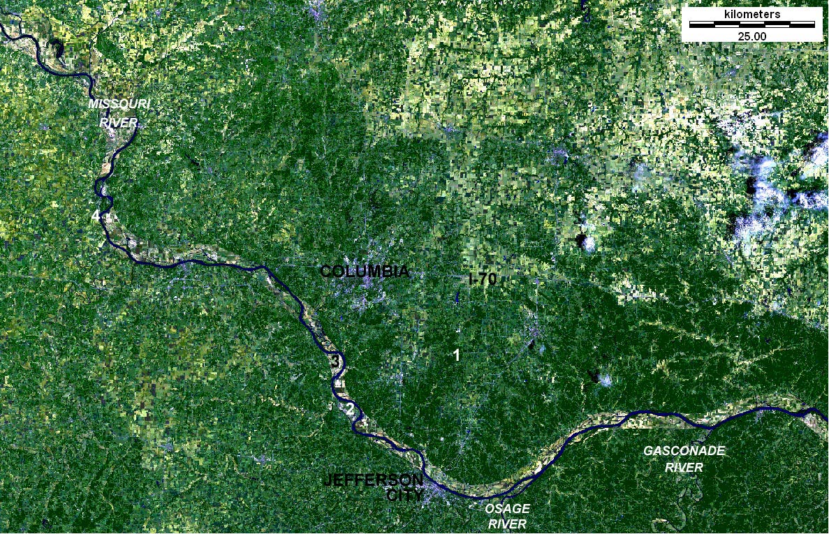
| Jefferson City and Columbia vicinity, Missouri. Landsat TM 257 composite; image date 18 June 1997. 1 - Mark Twain National Forest. 2 - Marion Bottoms Conservation Area. 3 - Plowboy Bend and Eagle Bluffs Conservation Areas. 4 - Arrow Rock State Historic Site. Arrow Rock, an important stopping point for travellers on the Missouri River, was reached by Lewis and Clark on June 9, 1804. |
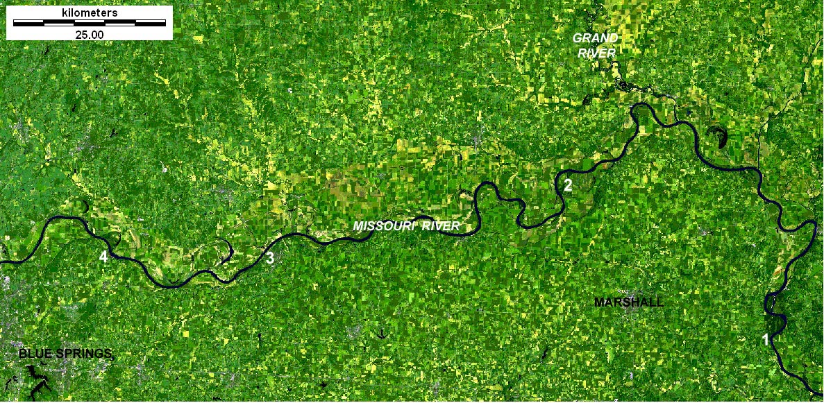
| Marshall and Blue Springs vicinity, Missouri. Landsat TM 257 composite; image date 22 July 2001. 1 - Arrow Rock. 2 - Grand Pass Conservation Area. 3 - Battle of Lexington State Historic Site. 4 - Fort Osage. The latter was founded by Clark in 1808 as a fortified trading post for dealing with Native Americans of the region. See Fort Osage National Historic Landmark. |

| Independence, Kansas City and Leavenworth vicinity, Missouri and Kansas. Landsat TM 257 composite; image date 2 July 1997. 1 - Fort Leavenworth military reservation. 2 - Approximate site of Fort de Cavagnial. 3 - Lewis and Clark State Park. Lewis and Clark reached the mouth of the Kansas (Kaw) River on June 26, 1804. On July 2, they visited the remains of the former French Fort de Cavagnial, near modern Fort Leavenworth. See treasures of the Steamboat Arabia, Kansas City, Missouri. |
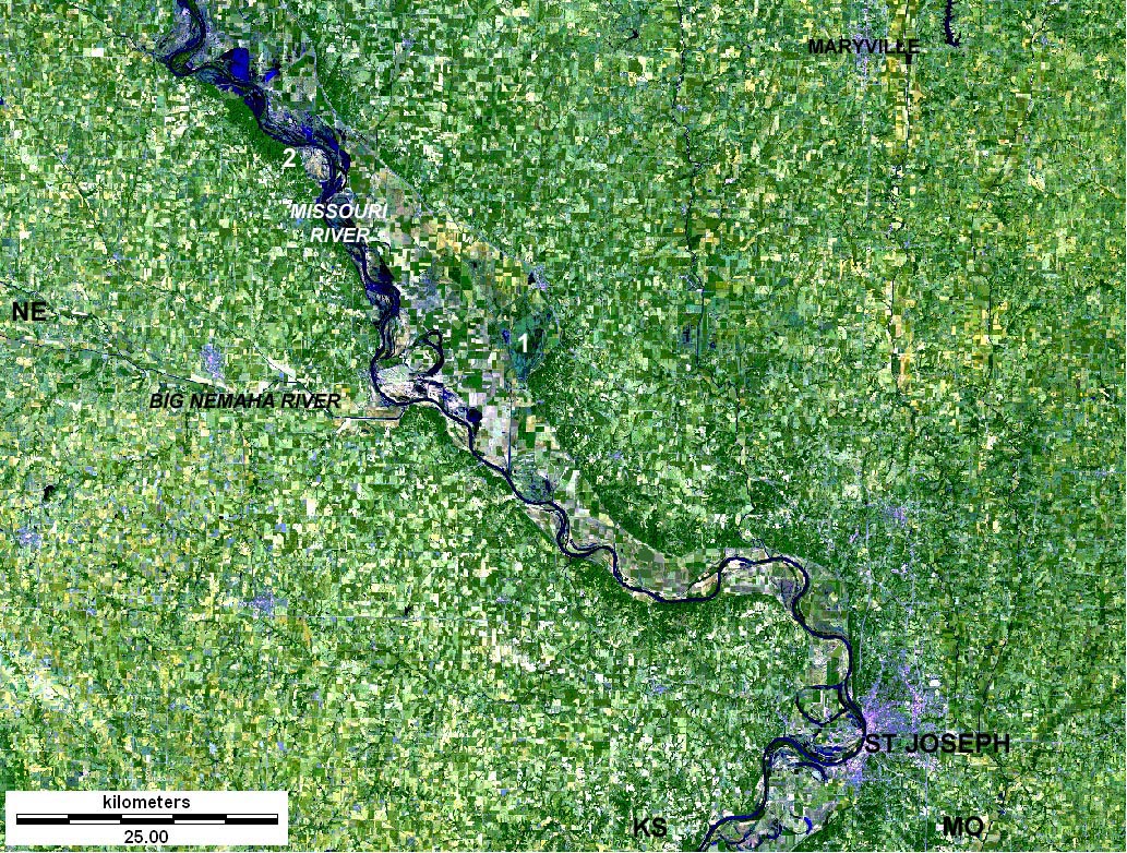
| St. Joseph and Maryville vicinity, Missouri, Kansas and Nebraska. Landsat TM 257 composite; image date 2 July 1997. 1 - Squaw Creek National Wildlife Refuge, 2 - Indian Cave State Park. St. Joseph was the headquarters and starting point of the Pony Express (1860-61). Note several oxbow lakes and cutoff meanders near St. Joseph. For more information about this section, see Squaw Creek NWR. |
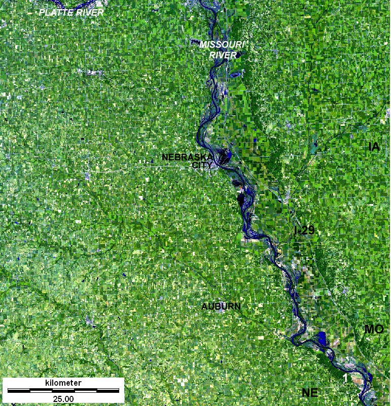
| Auburn and Nebraska City vicinity, Nebraska, Missouri and Iowa. Landsat TM 257 composite; image date 25 July 1997. 1 - Indian Cave State Park. Nebraska City, a former riverboat town, is home to the Arbor Lodge State Historical Park as well as Morton Orchard and Tree Farm. Both honor J. Sterling Morton, the founder of Arbor Day. |
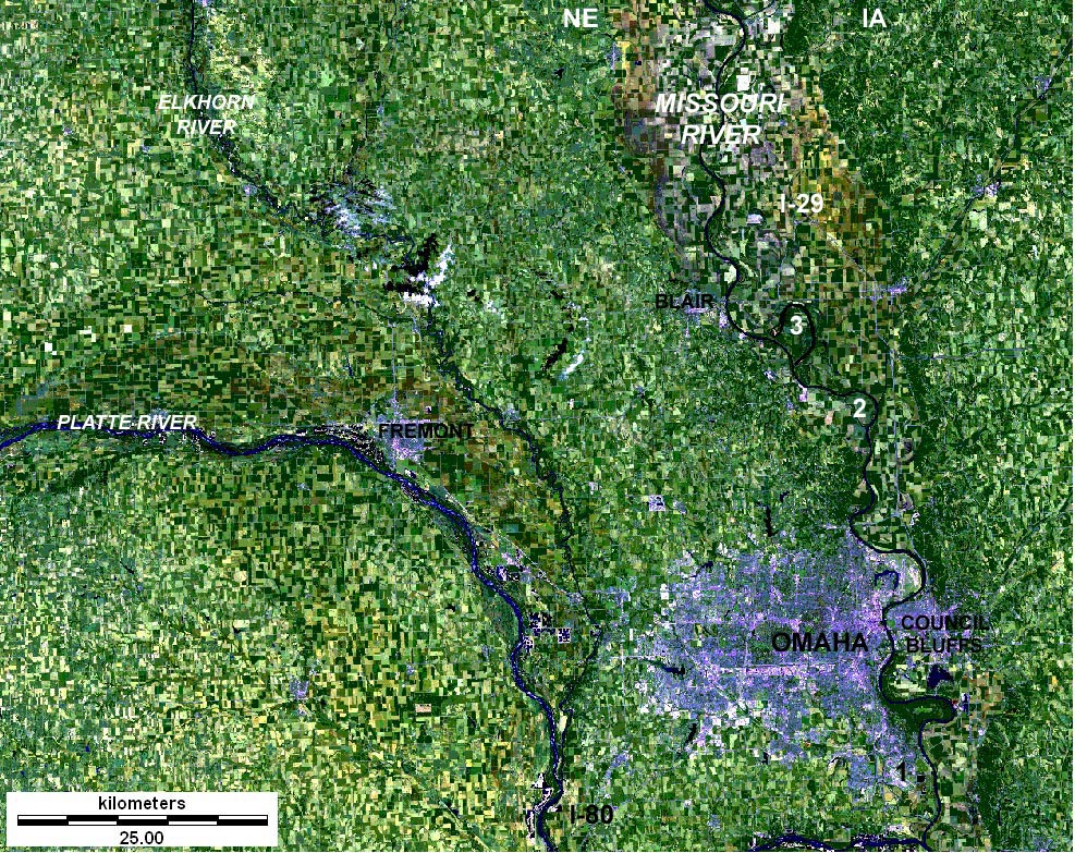
| Omaha and Council Bluffs vicinity, Nebraska and Iowa. Landsat TM 257 composite; image date 4 July 2001. 1 - Offutt Air Force Base. 2 - Boyer Chute National Wildlife Refuge and Fort Atkinson State Historical Park. 3 - DeSoto National Wildlife Refuge. See Steamboat Bertrand cargo collection. Lewis and Clark held their first council with Native Americans on August 3, 1804, just north of present Omaha. Lewis met with the Oto Indians and delivered a long speech that he was to repeat many times during the expedition. |
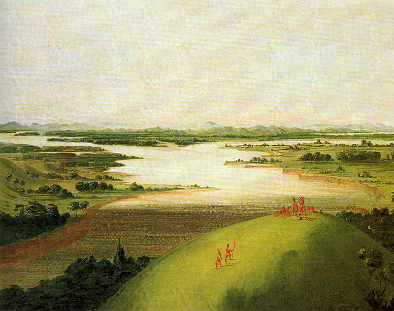
| Mouth of the Platte River. This scene depicts the western landscape just south of modern Omaha, Nebraska. George Catlin, 1832, oil. |
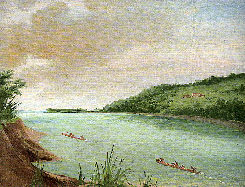
| Belle Vue, Indian Agency of Major Dougherty. A trading post and Indian agency near Council Bluffs, Iowa. George Catlin, 1832, oil. |

| Sioux City vicinity, Nebraska, Iowa and South Dakota. Landsat TM 257 composite; image date 4 July 2001. 1 - Lewis and Clark State Park. 2 - Sergeant Bluff. Sergeant Floyd died, apparently of appendicitis, on August 20, 1804. The crew buried him on a bluff south of modern Sioux City. A monument, erected in 1900 and dedicated in 1901, was the first site designated as a National Historic Landmark. |

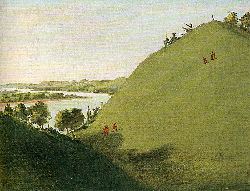
| Blackbird's Grave. View from behind with prairie wildflowers in bloom. Northeastern Nebraska near the town of Macy. George Catlin, 1832, oil. |
| Floyd's Grave, where Lewis and Clark buried Floyd in 1804. Sergeant Bluff, just south of modern Sioux City, Iowa. George Catlin, 1832, oil. |

| Sioux City and Yankton vicinity, Nebraska, Iowa and South Dakota. Landsat TM 257 composite; image date 16 July 1997. 1 - Ponca State Park. Lewis and Clark Lake is impounded behind Gavins Point Dam to regulate downstream flow of the Missouri River primarily for navigation and flood control. The lake and dam also provide hydroelectric power, irrigation water, recreation, and wildlife management for the region. |
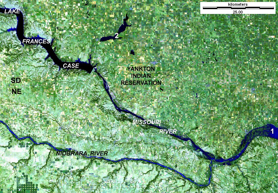
| Missouri and Niobrara rivers in southeastern South Dakota and northeastern Nebraska. Landsat TM 257 composite; image date 7 Sept. 2002. The Fort Randall Dam impounds Lake Frances Case a few miles north of the South Dakota/Nebraska boundary. This lake extends upstream more than 100 miles to Big Bend Dam. 1 - head of Lewis and Clark Lake. 2 - Lake Andes National Wildlife Refuge. |
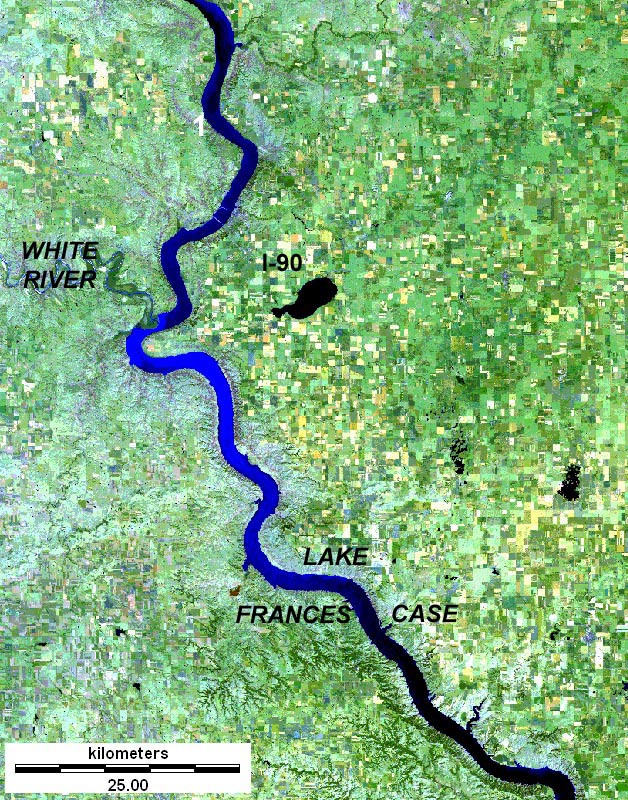
| Missouri and White rivers in south-central South Dakota. Landsat TM 257 composite; image date 7 Sept. 2002.
The White River, a major tributary draining from the South Dakota Badlands, carries a large sediment load into the Missouri, as shown by the delta and cyan water color entering Lake Frances Case. 1 - Fort Kiowa (1882). Lewis described the landscape thusly (Bergon 1989):
|
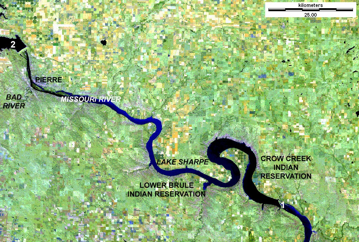
| Missouri River in Pierre vicinity, central South Dakota. Landsat TM 257 composite; image date 27 Sept. 2001.
Big Bend Dam in the southeastern corner of this scene takes its name from the huge loop in the Missouri River. Behind the dam, Lake Sharpe backs up almost to Pierre, the state capital city. 1 - Big Bend Dam. 2 - Lake Oahe. It was at the mouth of the Bad River, opposite modern Pierre, that Lewis and Clark confronted the powerful Teton Sioux Indians, who controlled all travel and trade up the Missouri River; their efforts at U.S.-Sioux diplomacy proved at best inconclusive (Ronda 1984). |
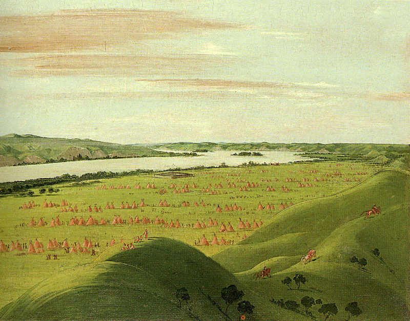
| Fort Pierre, mouth of the Bad River, central South Dakota. Six to seven hundred teepees fill the valley around the fort. George Catlin, 1832, oil. |
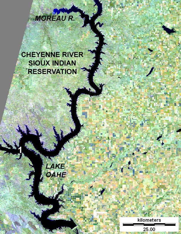
| Lake Oahe of the Missouri River, central South Dakota. Landsat TM 257 composite; image date 27 Sept. 2001.
Lake Oahe extends from South Dakota into North Dakota; it's the fourth largest man-made lake in the United States. The reservoir fulfills multiple functions: flood control, water supply, hydropower, fish and wildlife habitat, and recreation. 1 - mouth of the Cheyenne River (now an arm of Lake Oahe). Having survived the hostile Teton Sioux, Lewis and Clark continued upstream past mouths of the Cheyenne and Moreau rivers. This was territory of the Arikaras, and the Corps observed remains of many recently abandoned villages. Arikara population was much reduced by war and the outbreak of smallpox in 1780 (Ronda 1984). |
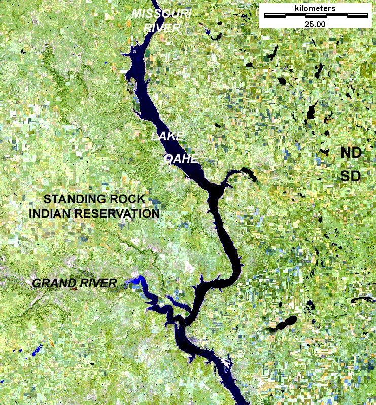
| Missouri and Grand rivers, Lake Oahe, northern South Dakota and southern North Dakota. Landsat TM 257 composite; image date 15 Sept. 2000. The region east of the Missouri River was covered by an ice sheet during the last glaciation, approximately 14,000 years ago, as evidenced by numerous large and small lakes. In early October 1804, Lewis and Clark met the Arikaras living in three large villages on an island in the Missouri near the mouth of the Grand River. Arikaras depended upon agriculture supplemented by buffalo hunting. They traded their agricultural surplus, namely corn and horses, with nomadic Sioux who supplied meat and European goods, particularly guns and powder. It was an economic relationship that benefitted both parties. Lewis and Clark's diplomatic effort to separate the Arikaras from the Sioux was superficially successful, but had no lasting effect (Ronda 1984). |

| Missouri River in Bismarck vicinity, south-central North Dakota. Landsat TM 257 composite; image date 15 Sept. 2000. 1 - Long Lake National Wildlife Refuge. North Dakota has a great many national wildlife refuges, more than most other states. Long Lake is part of a drainage system that carried glacial melt waters into the Missouri. It was at modern Bismarck that the Corps encountered its first grizzly bear, when according to Lewis (Bergon 1989):
|

| Missouri River in Fort Mandan vicinity, central North Dakota. Landsat TM 257 composite; image date 15 Sept. 2000. Garrison Dam impounds Lake Sakakawea on the Missouri River as well as Lake Audubon. Like other reservoirs on the Missouri River, these perform multiple roles for hydropower, irrigation, flood control, wildlife habitat, and recreation. 1 - Lewis and Clark National Historic Trail--reconstructed Fort Mandan. 2 - Knife River Indian Villages National Historic Site. 3 - Garrison Dam. 4 - Lake Sakakawea. 5 - Audubon National Wildlife Refuge. The Corps of Discovery spent the winter of 1804-05 in company with the Mandan and Hidatsa Indians in this vicinity--see Knife River Indian Villages National Historic Site for more details. |
River distance upstream from St. Louis is considerably shorter nowadays compared to the untamed Missouri River. The modern channel has been shortened and straightened by the U.S. Army Corps of Engineers. This channel is contained within levees and is maintained by dredging, in order to allow barge traffic as far upstream as Sioux City. The effects of this river control can be seen in South Dakota. Upstream from Sioux City, the river is relatively wide and shallow; many islands are present in the stretch between Vermillion and Yankton--see image above. Beginning near Sioux City and downstream to the Mississippi, the river is a single, narrow, deep channel that has few islands. Between St. Louis and Omaha, the Missouri River has been shortened by more than one quarter of its historic length (Gillespie 2000).
Return to Lewis and Clark atlas.River conditions
In the days of Lewis and Clark, the Missouri River was a wild, tangled network of multiple channels, islands and sand bars, choked with drifting logs and ice, filled with snags and sawyers, and subject to sudden floods. Sawyers were trees that slowly bobbed up and down in the muddy water; they could appear without warning and rip open a ship's hull. During the steamboat era of the mid-1800s, many ships were equiped with iron plates on the bow to guard against such dangers. Nonetheless, many steamboat accidents attested to the fickle nature of the Missouri River.
![]() Past and present Missouri River distances. Miles upstream from the wharf at St. Louis.
Past and present Missouri River distances. Miles upstream from the wharf at St. Louis. Location 1846 Today
Mouth of Missouri
St. Charles
Hermann
Mouth of Gasconade
Jefferson City
Arrow Rock
Lexington
Fort Osage
Wayne City (Independence)
Mouth of Kansas (Kansas City)
Fort Leavenworth
St. Joseph
Council Bluffs (Omaha)
![]() Related sites
Related sites
Last update: Mar. 2005.