James S. Aber
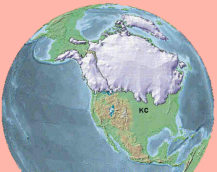
During the Pleistocene Epoch--past 1½ million years--several major glacial-interglacial cycles have taken place, each lasting about 100,000 years. The most recent glaciation is known as the Wisconsin in North America, after its excellent expression in the state of Wisconsin. This glaciation began about 110,000 years ago and reached its maximum extent between 20,000 and 14,000 years ago. A complex of ice sheets covered nearly all of Canada as well as the northern United States, and an ice lobe reached as far south as Des Moines, Iowa. Thereafter, the Wisconsin ice sheet collapsed and began shrinking rapidly. The modern or Holocene Epoch began 10,000 years ago.
|
| Reconstruction of the maximum extent of Wisconsin ice sheets in North America--20,000 to 14,000 years ago. Notice the prominent ice lobes that extended into lowlands along the southern margin of the ice sheet in the midcontinent region. "KC" indicates approximate location of the Kansas City vicinity. Adapted from Silkwood (U.S. Forest Service); used by permission. |
The glaciation of northeastern Kansas and northern Missouri took place much earlier. This glaciation is now known as the Independence, after Independence Creek in Doniphan County, Kansas. The name of this creek was given by Lewis and Clark on July 4th, 1804. The Independence ice sheet existed during the interval approximately 610,000 to 780,000 years ago, which makes it one of the oldest Pleistocene glaciations with a well-preserved record on land (Aber 1991). Because of their great age, sediments and landforms of the Independence glaciation have been strongly weathered, eroded, and in places covered by younger sediments (loess). Nonetheless a relatively good interpretation of glaciation is possible.

| Thick section of glacial sediments exposed in a gravel pit near Wathena, Kansas. The gray, bouldery layer is till. It rests on preglacial stream deposits (silt and gravel). Sand at top of the section was deposited in a glacial lake that covered much of northeastern Kansas. Photo date 6/85, © J.S. Aber. |
The Kansas City region was invaded by ice at least two times during the Independence glaciation. The early advance was the Minnesota ice lobe, which came through Iowa and entered the region from the northeast. This glaciation is marked by gray till that fills the preglacial valleys of the region. The Minnesota advance reached its maximum southern extent in the vicinity of Weston, Missouri and Leavenworth, Kansas (see map below).
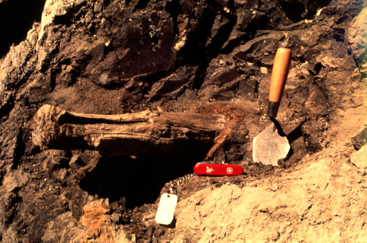
| Wood within till at Wathena, Kansas. Buried wood (spruce) is widespread in till of northeastern Kansas, northern Missouri, and eastern Nebraska. Photo date 9/89, © J.S. Aber. |
Prior to the early Independence glacier advance, a spruce forest grew in the region. To find a similar spruce forest today, one must travel to northern Manitoba, Canada or climb into the Rocky Mountains of Colorado. The presence of spruce indicates a much colder climate in northwestern Missouri and northeastern Kansas than today. As ice approached, trees were killed by extremely cold conditions. The landscape became a tundra, and wood remains were incorporated into till when ice overran the region (see photo above).
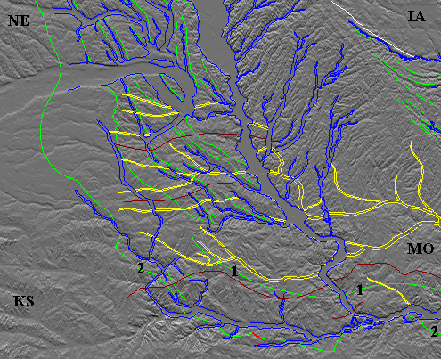
|
1 = Limit of early Independence glacial advance.
|
Map adapted from GAGE pre-Wisconsin mapping project.
See glacial map of the north-central United States.
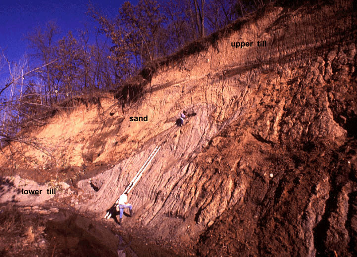
| Glacial section near Atchison, Kansas. The lower gray till represents the early Independence ice advance from the northeast, and the upper brown till was deposited by the late Independence advance from the northwest. The intervening sand accumulated in glacial Lake Atchison. Glacier movements disturbed the sediments creating folds and a large intrusion (top of ladder). Photo date 10/87, © J.S. Aber. |
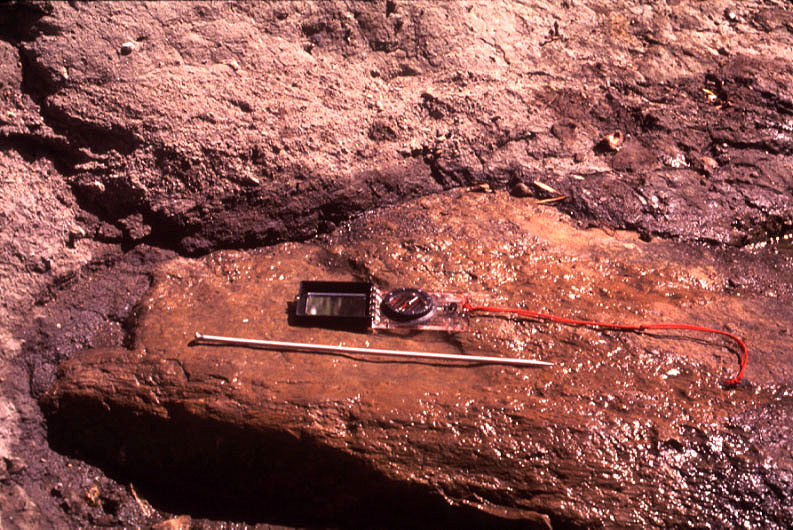
| Limestone boulder embedded in the lower gray till at Atchison, Kansas. Orientation of glacier flow is indicated by scratches and grooves on the boulder surface--needle points in direction of ice movement. Photo date 9/87, © J.S. Aber. |
When Lake Atchison filled with water, it overflowed, and outlet channels were eroded across the preglacial drainage divide to the south. This is the origin of the Big Blue River valley as well as the Missouri River valley south of Leavenworth. These spillways connected with the preglacial Kansas-Missouri river valley, which continued east of Kansas City. Thus, major river valleys of the region came into being as ice-marginal drainage routes. Catastrophic floods of glacial meltwater and sediment washed through these valleys, which carried runoff from the ice sheet as well as the northern Plains and northern Rocky Mountains. Once established in the relatively resistant Paleozoic bedrock of the region, these valleys have remained permanent features.
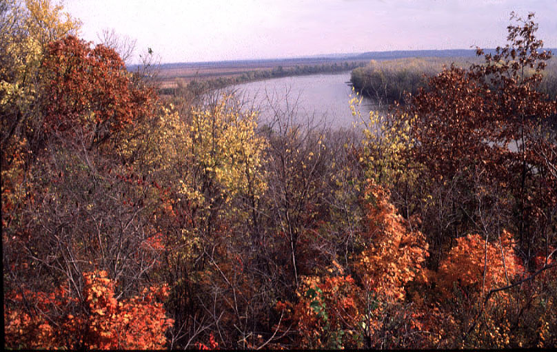
| Missouri River valley seen from Atchison, Kansas looking toward the northeast. This valley carried immense floods of glacial meltwater and sediment during the Independence and later glaciations. Photo date 10/89, © J.S. Aber. |
The modern Missouri River valley displays distinct variations in its width. In places the valley is many miles wide. Wide portions of the valley are found where the modern valley crosses preglacial valleys (see map above). In the Kansas City vicinity, in contrast, the valley is only a couple of miles across. Here thick, resistant limestone bedrock of the Lansing and Kansas City groups has limited valley erosion. High bedrock bluffs are conspicuous, especially along the southern valley side.
During the late Independence glaciation, ice lobes advanced farther south and locally blocked the Kansas and Missouri River valleys east and west of Kansas City. Numerous meltwater spillways were eroded as glacial lakes filled and overflowed along the maximum limit of glaciation. These spillways are preserved as valleys parallel to and south of the Kansas and Missouri river valleys. Some of these spillways were later filled with sediment, and others remain open valleys today. A good example of the latter is the Wakarusa River valley in Shawnee and Douglas counties, Kansas.

| View of downtown Kansas City, Missouri seen from the top of the Liberty Memorial. The Union Station and train tracks occupy a buried valley that crosses Kansas City from west to east. This partly filled valley provided a favorable route for construction of railroads connecting the Missouri River valley with the Kansas River valley. Photo date 6/83, © J.S. Aber. |
A partially filled spillway valley crosses the central portion of Kansas City, Missouri. This valley is an eastward continuation of Turkey Creek valley. The Union Station is located in this valley, and the railroad follows the valley from the West Bottoms of the Kansas River valley to the Missouri River valley to the east. The valley is filled with as much as 200 feet (60 m) of sand and gravel. This valley functioned as a meltwater spillway when the ice margin lay across modern downtown Kansas City, Missouri. The Missouri River valley was blocked, and upstream meltwater from the Missouri and Kansas river valleys overflowed and eroded a series of outlet channels across Kansas City, Kansas and Kansas City, Missouri. Similar meltwater valleys are located east of Independence, Missouri--Little Blue-Buckner valley (McCourt 1917).
A great deal of fine (silt) sediment was deposited on the Missouri River valley floor during the late Wisconsin glaciation. Strong westerly winds whipped up dust storms that carried the silt across the landscape. Thick deposits of wind-blown dust accumulated near the valleys. This silty sediment, known as loess, caps the bluffs and uplands of northeastern Kansas and northwestern Missouri. Loess is particularly thick to the east (downwind) from the Missouri River valley. The loess continues eastward across Missouri, Iowa, Illinois, and Indiana. Loess is especially good for agricultural soil and is the basis of the mid-American "corn belt."

| Wyeth Bluff section at St. Joseph, Missouri. River sediment (silt/sand) is present beneath a cap of loess. The loess represents dust blown from the Missouri River valley during the late Wisconsin glaciation 20,000 to 14,000 years ago. Photo date 6/85, © J.S. Aber. |
Cold climate of the late Wisconsin glaciation had a dramatic impact on flora and fauna of the region. A white spruce (Picea glauca) forest covered northeastern Kansas and northwestern Missouri (Fredlund and Jaumann 1987), similar to the boreal forest of central Manitoba today. Typical Ice Age animals roamed the area. Many vertebrate fossils are found in sediments of late Pleistocene and early Holocene age. Among the more spectacular finds are mastodon, stag moose, giant beaver, giant peccary, archaic bison, and woodland musk ox (Johnson 1987).

| Gravel dredged from the Kansas River channel at Bonner Springs, Kansas. The river here is reworking older channel deposits that date from the late Pleistocene and early Holocene. Photo date 8/86, © J.S. Aber. |
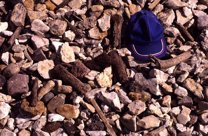
| Collection of wood fragments from the Kansas River gravel at Bonner Springs, Kansas. These gravels often contain bones of Ice Age animals as well as rare human bones and stone tools. Photo date 8/86, © J.S. Aber. |
Human bones and artifacts also have been found in late Pleistocene and early Holocene sediments of the region. The earliest stone artifacts are Clovis points, well-made spear points that represent the first so-called Paleo-Indian cultures in North America (Johnson 1987). Paleo-Indians were big-game hunters--specifically Clovis peoples hunted mammoth across the Great Plains region. At well-dated sites elsewhere, Clovis remains fall in the age range 11,500 to 11,000 radiocarbon years ago. At the end of the Pleistocene, some 12,000 to 10,000 years ago, significant changes happened in the Great Plains region of North America.
Many Folsom and Plano sites contain hundreds of bison bones, but bison survived to modern times. Among the many extinct animals, most were not significant prey for early man. Some animals that became extinct in North America--horse and camel--survived in Eurasia. Thus, it is difficult to make a strong case for overhunting as the primary cause for extinctions. The wave of extinctions coincided with rapid climatic changes at the end of the last glaciation. Climatic changes led to major alterations in vegetation cover on which herbivores depended, which precipitated an ecological crisis for large land animals.
Return to Kansas City geology homepage.
Last update Feb. 2005; © J.S. Aber.