The following images were acquired with a digital camera under partly overcast conditions in mid-October, 2002. All images © by the authors.

| View southward over the headquarters complex. The large stone building in lower left is the original ranch bunk house. At scene center is the original stone barn, and the red structure behind the barn is the buffalo corral. Other modern administrative and safety buildings can be seen to the left. |

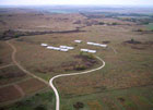
| View toward the southwest over the Flint Hills landscape. Various test plots can be seen in the foreground along with covered sheds at scene center. |

| View toward the northeast. Mixed land cover includes agricultural fields, pasture, and woodland. The Kansas River is visible in the center distance. A public parking area appears in the lower left corner and a nature trail extends from there across scene center. |

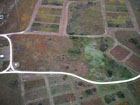
| Kite flyers are situated in upper left part of this view, surrounded by test plots of various sizes, shapes, and types. Note the variety of vegetation colors in this autumn scene. |

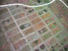
| Low-oblique, closeup view of vegetation test plots. Each plot shows marked differences in colors and textures of grasses, shrubs and other plants. Bare limestone also appears scattered around the site. |